Luzhin Street
| Luschinstrasse | ||
|---|---|---|
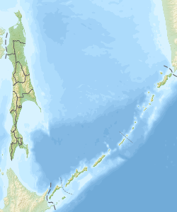
| Map of the northern Kuril Islands with Russian names. Luschin Street is in the center of the picture with north-south orientation between the largest island in the northern group to the east - Paramushir - and the very small Anziferow Island. | ||
| Connects waters | Sea of Okhotsk (to the north) | |
| with water | Fourth Kuril Street (in the south) | |
| Separates land mass | Paramushir (in the east) | |
| of land mass | Anziferow Island (to the west) | |
| Data | ||
| Geographical location | 50 ° 12 ' N , 155 ° 6' E | |
|
|
||
| Smallest width | 15 km | |
The Luzhin Strait ( Russian пролив Лужина proliv Loezjina ), also known as the Third Kuril Strait , is a 15 km wide strait in the Sea of Okhotsk between the two Kuril islands of Paramushir and Anziferov Island .
The strait was named after the Russian geodesist and cartographer Fyodor Luschin (* unknown, † 1727).
Eelpout ( Gymnelus soldatovi ) were found m in the strait at a depth of 100th
literature
- I. Sonn, A. Kostjanoi: Okhotskoye more: enziklopedija . Meschdunarodnyje otnoshenija, Moscow 2009, p. 104. ISBN 978-5-7133-1354-8 (Russian)
Individual evidence
- ↑ Russian ЛУЖИН Федор Федорович . Northern Pacific. Retrieved June 10, 2007.
- ↑ Anderson, M. Eric (February 2004) "Family Zoarcidae Swainson 1839 eelpouts" Annotated Checklists of Fishes No. 34, p. 6 ( Memento from September 28, 2007 in the Internet Archive ) (PDF; 190 kB)

