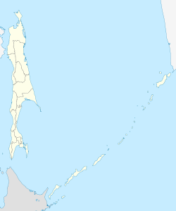
Tymovskoye
| Urban-type settlement
Tymovskoye
Tymovsky
|
||||||||||||||||||||||||||||||||||||
|
||||||||||||||||||||||||||||||||||||
|
||||||||||||||||||||||||||||||||||||
Tymovskoye ( Russian Тымовское ) is an urban-type settlement in Sakhalin Oblast ( Russia ) with 7855 inhabitants (as of October 14, 2010).
geography
The settlement is located in the central part of the Sakhalin Island in the valley of the Tym River on its right bank. The valley separates the western part of the Sakhalin Mountains from the eastern part, in which the Lopatin Mountain lies a good 30 kilometers east of Tymovskoye, the highest point on Sakhalin Island at 1608 meters (named after the mining engineer Innokenti Lopatin, who was one of the first Russians to visit the area in 1868 explored).
Since 1965, Tymovskoye has been the administrative center of the Tymovskoye Rajon, which was created after several changes . The place is a good 450 kilometers (as the crow flies) north of the oblast capital Yuzhno-Sakhalinsk .
history
In connection with the use of Sakhalin by the Russian Empire as an island of prison and exile , the Malo-Tymowo and Bolshoje Tymowo settlements arose from 1877 and 1878, not far from today's location. The latter was soon given the name Rykovskoye in honor of the founder, Sergeant Yakov Rykow, and grew rapidly, had 2,000 inhabitants in 1886 and remained one of the three centers of the Sakhalin Katorga and responsible for the north-eastern part of the island (next to Alexandrowsk in the west and Korsakow) until their dissolution in the south). The village, located 15 kilometers south of Tymovskoye, is now called Kirovskoye.
On July 5, 1880, another village for exiles was founded downstream from Anton Derbin, which was named Derbinskoje after this. In 1890 the writer Anton Chekhov visited the village on his Sakhalin trip and described it in his book The Island of Sakhalin .
During the Russo-Japanese War 1904/05, the area around Rykovskoye and Derbinskoye was occupied by Japanese troops in July 1905, as it was after the Russian October Revolution of 1917 (the Bolsheviks did not take power on Sakhalin until the beginning of 1920), as Japan from April 1920 until May 1925 also occupied the entire northern part of the island.
In 1928 the administrative center of Rykovskoye Rajon was moved to Derbinskoye. On November 15, 1949, the place was given its current name.
In 1963 the place was given urban-type settlement status.
Population development
| year | Residents |
|---|---|
| 1890 | 739 |
| 1939 | 2,350 |
| 1959 | 5,412 |
| 1970 | 7,974 |
| 1979 | 9,476 |
| 1989 | 10,869 |
| 2002 | 8,532 |
| 2010 | 7,855 |
Note: from 1939 census data
Personalities
- Ivan Juwachev (1860–1940), naval officer, Narodowolze and writer ( "Eight Years on Sakhalin" under the pseudonym Miroljubow ), father of the writer Daniil Charms ; Served a death sentence converted into forced labor in the Rykovsk Katorga
- Bronisław Piłsudski (1866–1918), Polish ethnologist , served part of the sentence of 15 years of forced labor for the planned murder of Tsar Alexander III. in Rykovskoye; worked as an ethnologist on Sakhalin for several years on behalf of the Russian Academy of Sciences
Economy and Infrastructure
There are forestry and food industries in Tymovskoye.
The settlement is located on the main line of the narrow-gauge railway network ( cape gauge 1067 mm) of the Sakhalin Island (route km 539 from Korsakow via Yuzhno-Sakhalinsk; station name Tymovsk ) leading to Nogliki . Tymovskoye was reached during the construction of the northbound route in the 1970s. The largest locomotive depot in the northern section of the line is located here.
The regional road R487 runs through the village from Yuzhno-Sakhalinsk via Poronaisk to Alexandrowsk-Sakhalinsky, from which a road branches off down the Tym and along the railway line to Nogliki on the east coast of the island and on to Ocha .
Individual evidence
- ↑ a b Itogi Vserossijskoj perepisi naselenija 2010 goda. Tom 1. Čislennostʹ i razmeščenie naselenija (Results of the All-Russian Census 2010. Volume 1. Number and distribution of the population). Tables 5 , pp. 12-209; 11 , pp. 312–979 (download from the website of the Federal Service for State Statistics of the Russian Federation)
- ↑ S. Gorbunow: Das Tym-Tal: Steps of History ( page no longer available , search in web archives ) Info: The link was automatically marked as defective. Please check the link according to the instructions and then remove this notice. - Article on the Poronaisk Local History Museum website (Russian, PDF)
Web links
- Tymovskoye on the Sakhalin Oblast Administration website (in Russian)


