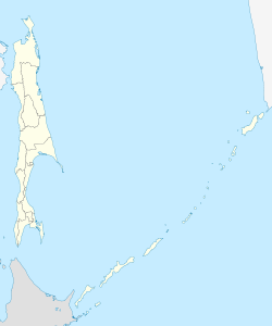
Nogliki
| Urban-type settlement
Nogliki
Ноглики
|
||||||||||||||||||||||||||||||||
|
||||||||||||||||||||||||||||||||
|
||||||||||||||||||||||||||||||||
| List of large settlements in Russia | ||||||||||||||||||||||||||||||||
Nogliki ( Russian Ноглики ) is an urban-type settlement in Sakhalin Oblast ( Russia ) with 10,231 inhabitants (as of October 14, 2010).
geography
The settlement is located near the east coast of Sakhalin Island , about six kilometers from the shore of the Sea of Okhotsk on the right bank of the Tym River , one of the most important on the island, not far from its confluence with the Nyjski lagoon . The Imtschin and Nogliki rivers flow into the Tym near the settlement.
Nogliki is the administrative center of the Nogliki Rajon of the same name . It is a good 600 kilometers (as the crow flies) north of the Oblast capital Yuzhno-Sakhalinsk .
history
Nogliki emerged from the late 1940s in connection with the exploration of oil deposits in northeast Sakhalin. In 1960 urban-type settlement status was given.
Population development
| year | Residents |
|---|---|
| 1939 | 1,237 |
| 1959 | 2,197 |
| 1970 | 5,213 |
| 1979 | 7.130 |
| 1989 | 11,546 |
| 2002 | 10,729 |
| 2010 | 10,231 |
Note: census data
Economy and Infrastructure
Nogliki is the supply base for the natural gas and oil deposits Sakhalin I and Sakhalin II to the northeast of the settlement off the coast of Sakhalin . There are also forestry companies.
The settlement is the northern end point of the main line of the railway network (1520 mm Russian broad gauge ) of the Sakhalin Island (route km 662 from Korsakow via Yuzhno-Sakhalinsk). The line, the construction of which had already begun before 1945 in the southern part of the island, which was then part of Japan, reached Nogliki in 1978.
As early as 1953 Nogliki was reached by a railway line coming from the north with a gauge of 750 mm, the construction of which had begun during the Japanese occupation of the northern part of the island around Ocha in 1925. Continuous passenger traffic on the 228-kilometer route from Ocha was discontinued as a result of the opening of the Cape Gauge route in the 1980s; In 2006 there was still modest freight traffic on what is now Rosneft's route. The 20-kilometer section from Nogliki to the southeast via the Katangli settlement to the Nabil pier on the seashore was dismantled in the 1990s.
On September 17, 2007, an airport to serve the oil and gas production areas was put into operation.
Individual evidence
- ↑ a b Itogi Vserossijskoj perepisi naselenija 2010 goda. Tom 1. Čislennostʹ i razmeščenie naselenija (Results of the All-Russian Census 2010. Volume 1. Number and distribution of the population). Tables 5 , pp. 12-209; 11 , pp. 312–979 (download from the website of the Federal Service for State Statistics of the Russian Federation)
- ↑ Private website about the narrow-gauge railway Ocha – Nogliki (Russian, many photos)
- ↑ Report ( Memento of the original from June 10, 2011 in the Internet Archive ) Info: The archive link was inserted automatically and has not yet been checked. Please check the original and archive link according to the instructions and then remove this notice. in Kommersant , September 18, 2007


