Yap Islands
| Yap Islands | ||
|---|---|---|
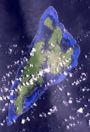
| NASA satellite image | ||
| Waters | Pacific Ocean | |
| archipelago | West Carolines | |
| Geographical location | 9 ° 32 ' N , 138 ° 7' E | |
|
|
||
| Number of islands | 14th | |
| Main island | Yap | |
| Land area | 100.16 km² | |
| Lagoon area | 26 km² | |
| Highest elevation | Taabiywol 169 m |
|
| Residents | 6300 | |
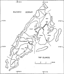
| Map of the Yap Islands | ||
| Map of the archipelago | ||
The Yap Islands are one in the archipelago of the Western Carolines located Atoll in the Pacific . They are 1,300 km from New Guinea and 870 km from Guam and politically belong to the Federated States of Micronesia .
geography
General
The group consists of four larger volcanic and about ten small coral islands, which are close together and surrounded by a common wedge-shaped fringing reef . The four larger islands are
- Yap (the main island of the archipelago) (56.15 km²)
- Gagil-Tomil (28.82 km²)
- Maap (10.64 km²)
- Rumung (4.30 km²)
The remaining ten islands
- Bileegiliy (Ruul)
- Biy (Tamil Harbor)
- Dilmeet (Maap)
- Fangaamat (Ruul)
- Garim (south)
- Paakeal (Tamil Harbor)
- Qaelik (south) (rocks)
- Ruunguch (Maap)
- Taraang (Tamil Harbor)
- Mitheathow (before Gagil)
only have a total area of 0.24 km² or 24 hectares .
The inhabited islands of the group are of volcanic origin, hilly, densely forested and populated in the coastal regions. The other islands of Yap are all small and shallow uninhabited coral islands . The surrounding fringing reef includes a lagoon of 26 km².
Location of the islands
![]() Map with all coordinates: OSM | WikiMap
Map with all coordinates: OSM | WikiMap
| Island name | Coordinates | Area (km²) | Residents |
|---|---|---|---|
| Yap | 09 ° 31 ' N , 138 ° 06' E | 56.15 | 6,000 |
| Gagil-Tomil | 09 ° 33 ' N , 138 ° 10' E | 28.82 | 1,670 |
| Maap | 09 ° 36 ' N , 138 ° 10' E | 10.64 | 590 |
| Rumung | 09 ° 37 ' N , 138 ° 09' E | 4.30 | 125 |
| Bileegiliy | 09 ° 30 ' N , 138 ° 06' E | ... | 0 |
| Fangaamat | 09 ° 29 ' N , 138 ° 06' E | ... | 0 |
| Garim | 09 ° 27 ' N , 138 ° 05' E | ... | 0 |
| Biy | 09 ° 31 ' N , 138 ° 08' E | ... | 0 |
| Taraang | 09 ° 32 ' N , 138 ° 08' E | ... | 0 |
| Paakeal | 09 ° 32 ' N , 138 ° 08' E | ... | 0 |
| Dilmeet | 09 ° 37 ' N , 138 ° 11' E | ... | 0 |
| Ruunguch | 09 ° 35 ' N , 138 ° 09' E | ... | 0 |
| Qaelik | 09 ° 27 ' N , 138 ° 04' E | ... | 0 |
| Mitheathow | 09 ° 34 ' N , 138 ° 12' E | 0.00064 | 0 |
The islet Mitheathow , which according to old maps is only a few meters off the northeast coast of Gagil-Tomil , appears on current satellite images as being connected to Gagil due to mangrove growth.
history
The first Europeans to see the Yap Islands were believed to be Spanish sailors. The islands were in Spanish colonial possession until 1899 , after which the area was sold to the German Empire . In 1912/13 a large radio station was built which played a central role in the communications system of the colonies of German New Guinea and German Samoa . In 1914 the islands were occupied by Japanese forces. From 1919 to 1945 the islands were a Japanese mandate, as Japan was awarded the islands in the Versailles Peace Treaty . In 1945 the islands were occupied by US troops. From 1947 the Yap Islands belonged to the Oceanic Trustee Area Pacific Islands , which was under administration by the USA . In 1979 the Yap Islands merged with other (island) areas in the Carolines archipelago to form the now independent island nation of the Federated States of Micronesia (FSM). The islands are known for exceptionally large cash of stone that Rai be mentioned.
administration
The Yap Islands (and over 145 small islands and atolls ) are politically part of the state of Yap , a part of the Federated States of Micronesia (FSM). The Yap Islands are called Yap Proper and the other atolls and islands are called the Outer Islands .
Ten of the 22 municipalities ( municipalities ) of the state of Yap attributable to the Yap Islands, six of them to the main island Yap , two on the island Gagil-Tomil and one each of the islands Maap and Rumung :
-
Yap (island)
- Fanif
- Weloy
- Rull
- Dalipebinau
- Kanifay
- Gilmaan
-
Gagil-Tomil
- Gagil
- Tomil
- Maap
- Rumung
These ten municipalities of the Yap Islands are traditionally more in villages ( villages divided), a total of 129, of which 38 are now uninhabited.
Colonia , the capital of the state of Yap, is located on the east coast of the island of Yap of the same name , and consists of the communities Weloy and Rull.
Culture
The cultural highlight of the year is Yap Day , a festival that takes place in the first week of March, when dance groups from several villages on the main island gather. It is the most important of the four national holidays and is used to preserve and revive traditional culture. Are popular seat dances of women and stick dances by men. In 1999 the festival was extended to three days for the first time, with canoe races on the third day.
literature
- Erich Kaiser: Contributions to the petrography and geology of the German South Sea Islands. In: Yearbook of the Royal Prussian Geological State Institute and Mining Academy in Berlin for the year 1903. Volume XXIV, Berlin 1907, pp. 93–121. pdf
Individual evidence
- ↑ Reinhard Klein-Arendt: “Kamina ruft Nauen!” The radio stations in the German colonies 1904–1918. Wilhelm Herbst Verlag, Cologne 1995, ISBN 3-923925-58-1 , p. 226ff.
- ^ Sherwood Lingenfelter : Yap: Political Leadership and Culture Change in an Island Society. The University Press of Hawaii, Honolulu 1975, p. 79.
- ↑ Toru Aoyama: Yap Day: Cultural Politics in the State of Yap. (PDF; 198 kB) Kagoshima University Research Center for the Pacific Islands. Occasional Papers, No. 34, 2001, pp. 1-13.


