Eauripik
| Eauripik | ||
|---|---|---|
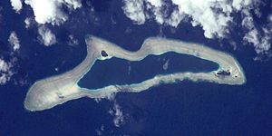
| ISS photo by Eauripik | ||
| Waters | Pacific Ocean | |
| archipelago | Carolines | |
| Geographical location | 6 ° 42 ' N , 143 ° 3' E | |
|
|
||
| Number of islands | 6th | |
| Main island | Eauripik Island | |
| length | 11 km | |
| width | 3 km | |
| Land area | 23.6 ha | |
| Lagoon area | 5.921 km² | |
| total area | 20 km² | |
| Residents | 113 (2000) | |
Eauripik (formerly Kama Island ) is an atoll in the Pacific Ocean and is located in the Caroline Archipelago . Eauripik is the southernmost atoll in the state of Yap , which together with three other states forms the Federated States of Micronesia .
geography
The elongated atoll is one of the Outer Islands of Yap. On the wide reef rim, which completely surrounds the central lagoon , there are three small motu with a land area of 0.2 km² and a lagoon area of 6 km². The main island is Eauripik Island .
113 people live on the atoll (2000 census).
Islands
The six islands lie along the north side of the reef rim, from west to east:
![]() Map with all coordinates: OSM | WikiMap
Map with all coordinates: OSM | WikiMap
| island | (Surname) | Area ( ha ) |
location | Coordinates |
|---|---|---|---|---|
| Edarepe | Yaetalhiipiy | 0.4 | west | 06 ° 41 ′ 12.6 " N , 143 ° 00 ′ 34.1" E |
| Elangkileku | Aelangakiite | ... | south | 06 ° 41 ′ 20.0 ″ N , 143 ° 03 ′ 36.0 ″ E |
| Oao | Oau | 7.7 | north | 06 ° 41 ′ 58.0 ″ N , 143 ° 01 ′ 51.7 ″ E |
| Bekefas | Pigefash | ... | south | 06 ° 41 '24.0 " N , 143 ° 03' 36.0" E |
| Eauripik | Aurepik | 10.2 | east | 06 ° 40 ′ 58.7 " N , 143 ° 04 ′ 40.2" E |
| Siteng | Sitiing | 0.6 | Eastern tip | 06 ° 40 ′ 50.8 " N , 143 ° 04 ′ 55.0" E |
| Eauripik (Atoll) | Kama Island | 23.6 | Fringing reef | 06 ° 41 ′ 26.0 ″ N , 143 ° 02 ′ 27.0 ″ E |
All islands except Edarepe are covered with coconut palms . Edarepe is devoid of vegetation and is flooded during floods.
The islands of Elangkileku and Bekefas on the southern rim of the reef can not (no longer) be made out on the ISS photo .
history
The German-Baltic captain of the Russian Navy and later Admiral Friedrich Benjamin von Lütke discovered Eauripik for Europe on April 12, 1828 during his circumnavigation of the world from 1821 to 1824.
Individual evidence
- ^ Otis W. Freeman, Geography of the Pacific, Wiley 1953
- ↑ World Gazetteer ( Memento of the original from June 22, 2011 in the Internet Archive ) Info: The archive link was inserted automatically and has not yet been checked. Please check the original and archive link according to the instructions and then remove this notice.
- ↑ MapPlanet
- ↑ Sailing Directions Enroute, Vol. 126, Pacific Ocean
- ^ Andrew Sharp: The Discovery of the Pacific Islands . Greenwood Press, Westport (CT) 1960, p. 217
- ^ John Dunmore: Who's Who in Pacific Navigation. University of Hawaii Press, Honolulu 1991, p. 165
Web links
- Eauripik on Oceandots ( Memento from December 23, 2010 in the Internet Archive )
- [1] (PDF; 781 kB) Population Growth in three Pacific Ecosystems: Eauripik Atoll, American Samoa, and Hawaii. Eleanor C. Nordyke and Michael J. Levin, East-West Population Institute, Honolulu, Hawaii, May 29, 1979

