Gagil-Tomil
| Gagil-Tomil | ||
|---|---|---|
|
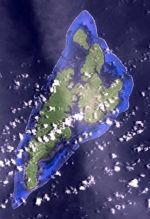
Satellite image of the Yap Islands (Gagil-Tomil center right) |
||
| Waters | Pacific Ocean | |
| Archipelago | Yap Islands | |
| Geographical location | 9 ° 32 '36 " N , 138 ° 9' 57" E | |
|
|
||
| surface | 28.82 km² | |
| Highest elevation | Buchaq 81 m |
|
| Residents | 1670 (2000) 58 inhabitants / km² |
|
| Map of the Yap Islands, with Gagil-Tomil in the east | ||
Gagil-Tomil , sometimes also Gagil-Tamil , but also Tomil-Gagil (more rarely Tamil-Gagil ) called, is the second largest island of the Yap Islands , a small group of islands in the western Pacific . This is approximately 1300 km from New Guinea and 870 km from Guam .
The forested island is northeast of Yap , separated by the 1300 meter long and over long stretches less than 10 meter wide Tagireeng Canal , and southeast of Maap (separated by the minimum 66 meter wide and 2100 meter long inlet Yunearawëy (Yuneroway) ).
At the 2000 census there were 1757 inhabitants on the island.
The two communities Gagil and Tomil gave its name to the double name . The municipality of Tamil also extends to the neighboring island of Yap , which means that the local village of Gargey also belongs to the municipality of Tamil. The population of the island of Gagil-Tomil recorded in the census of 1757 thus includes (strictly speaking) the inhabitants of Gargey. The island population of Gagil-Tomil adjusted for this number of inhabitants is therefore an estimated only 1670 people.
Individual evidence
- ↑ Census report (PDF; 2.9 MB)
- ↑ estimated based on the distribution of the buildings (PDF; 169 kB)


