Lamotrek
| Lamotrek | ||
|---|---|---|
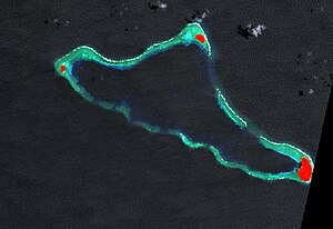
| False color - satellite image of NASA | ||
| Waters | Pacific | |
| archipelago | Carolines | |
| Geographical location | 7 ° 29 ′ N , 146 ° 20 ′ E | |
|
|
||
| Number of islands | 3 | |
| Main island | Lamotrek | |
| length | 15 km | |
| width | 6.5 km | |
| Land area | 98.2 ha | |
| Lagoon area | 31.51 km² | |
| total area | 41 km² | |
| Residents | 373 (2000) | |
|
Spanish nautical chart from 1886: Elato and Lamotrek |
||
Lamotrek is an atoll in the central Pacific Ocean . Geographically, it belongs to the Carolines Archipelago , politically it belongs to the state of Yap of the Federated States of Micronesia .
geography
Lamotrek is located in the east of Yap State, 9 km east of Elato Atoll and 71 km southwest of West Fayu . It is over 1000 km away from the Yap Islands in the west of the state. Lamotrek is an elongated atoll with a length of 15 km and a maximum width of 6.5 km. The total area of the atoll is 41 km². The lagoon accounts for 31.5 km² of this ; the land area, however, is just under 1 km². The atoll consists of three islands on the fringing reef , Falaite in the west, Pugue in the northeast and Lamotrek , the main island, in the southeast of the atoll. With 73.8 hectares, the main island is by far the largest and the only inhabited of the three islands. Pugue is 16.6 hectares and Falaite is 7.8 hectares. A small passage south of Pugue allows entry into the lagoon, which is up to 15 m deep. The islands are densely overgrown with coconut palms and breadfruit trees .
administration
Lamotrek forms its own municipality ( municipality ) of the same name with 373 inhabitants (status: 2000). It belongs to the fifth and easternmost electoral district of the state of Yap.
literature
- Kerstin JS Werle: Landscape of Peace: Mechanisms of Social Control on Lamotrek Atoll, Micronesia. [An ethnosociological study in the age of globalization]. Springer VS, 2014. ISBN 978-3-658-05831-9 (print); ISBN 978-3-658-05832-6 (eBook)
Web links
- Lamotrek on Oceandots ( Memento from December 23, 2010 in the Internet Archive )
- Page about Lamotrek with pictures (English)
Individual evidence
- ^ Atoll Area, Depth and Rainfall (2001) table of the Geological Society of America. Access on April 11, 2010 ( page no longer accessible , search in web archives ) Info: The link was automatically marked as defective. Please check the link according to the instructions and then remove this notice.
- ↑ UNEP Islands (English)
- ^ National Geospatial-Intelligence Agency: Sailing Directions (enroute), Pub. 126, Pacific Ocean (English; PDF; 5.1 MB)
- ↑ Yap State Census Report, 2000 (English; PDF; 2.9 MB)
- ↑ Yap in pacificworlds (English)


