Falalop
| Falalop | ||
|---|---|---|
| Falalop, east of Ulithi Atoll | ||
| Waters | Pacific Ocean | |
| Archipelago | Carolines | |
| Geographical location | 10 ° 1 '4 " N , 139 ° 47' 27" E | |
|
|
||
| length | 1.2 km | |
| width | 1.1 km | |
| surface | 93 ha | |
| Highest elevation | 6.7 m | |
| Residents | 481 (1987) 517 inhabitants / km² |
|
| main place | Wiliileg | |
| Map of the Ulithi municipality, with Falalop in the northeast | ||
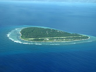
Falalop is one of the largest islands in the Micronesian state of Yap . It is located east of the Ulithi Atoll . The two villages on the island are Wiliileg and Paeliyaw .
geography
The almost one square kilometer large island of Falalop is often - incorrectly - referred to as part of the Ulithi Atoll, but lies well outside the eastern reef rim. Falalop is separated from Asor , the northeasternmost island in the Ulithi Atoll, by a deep and 400 meter wide channel ( Dochirichi Channel ).
The highest point on the island reaches 6.7 meters.
Falalop is the most populous island in the Yapese community of Ulithi .
history
During the Second World War , the Japanese built a radio and weather station on Falalop. After the conquest by the Americans in 1944, a runway for aircraft was built on the island.
Today, Falalop is developed for tourism and is considered a good diving area , especially after oil residues and ammunition from the warships that have sunk here have been removed.
Individual evidence
- ↑ Ulithi ( Memento of December 23, 2010 in the Internet Archive ) (English)
- ↑ Traditional Culture, Tourism, and Social Change in Mogmog Island, Ulithi Atoll ( Memento from June 26, 2006 in the Internet Archive ) (English)


