Ulithi (atoll)
| Ulithi | ||
|---|---|---|
| Aerial view of the northern part, looking west, with the main island Mogmog in the foreground | ||
| Waters | Pacific Ocean | |
| archipelago | Carolines | |
| Geographical location | 9 ° 58 ′ N , 139 ° 40 ′ E | |
|
|
||
| Number of islands | 40 | |
| Main island | Mogmog | |
| length | 36 km | |
| width | 24 km | |
| Land area | 3.57 km² | |
| Lagoon area | 548 km² | |
| Residents | 773 (2000) | |
| Map of the atoll and the neighboring islands to the east | ||
Ulithi is an atoll in the Pacific Ocean , part of the Caroline Islands , administered by the state of Yap and located approximately 191 km from the island of Yap . The closest neighbor is Fais , 82 km east of the atoll. The land area is 4.5 km² and the population is 773 ( census : 2000).
The Ulithi Atoll is administratively part of the Ulithi municipality .
geography
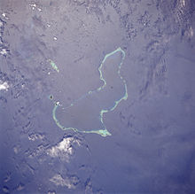
The irregularly shaped atoll stretches for 36 km from north to south. The width varies from 5 km in the south to a maximum of 24 km in the north. The total area is estimated at 480 km². The reef rim is broad and distinct in the north and south-east, and more interrupted in the north-east and west. The lagoon is deep, especially in the north, where depths of over 60 meters are reached.
The main island of Mogmog lies on the northern rim of the reef.
The island Falalop , which lies outside the reef rim, is often mentioned as the main island of the Ulithi atoll - incorrectly - although it is clearly separated from the nearest island Asor on the reef rim by the deep and 400-meter-wide Dochirichi Channel .
Most of the atoll islands are to the north and southeast, while there are only seven islets in the west.
population
The atoll has few inhabited islands. Mogmog is the seat of the chief of the Ulithi atoll. The other inhabited islands are ruled by their local chiefs.
| Inhabited island |
new name | Area ( ha ) |
Population 1987 |
Population 1970 |
Remarks |
|---|---|---|---|---|---|
| Azor | Yasor | 34 | 62 | 315 | |
| Mogmog | Mwagmwog | 26th | 191 | - | Seat of the chief chief |
| Fedarai (Fassarai) | Fedraey | 36 | 112 | 373 | |
| Lothou (Lossau) | ... | 15th | - | 59 | |
| rest | 246 | - | 522 | ||
| Ulithi | 357 | 366 | 1269 |
history
Ulithi Atoll, like the other outer islands of the Carolines, was probably settled by immigrants from Polynesia .
The Ulithi atoll was first discovered by whites in 1526 by the Portuguese navigator Diego da Rocha . The next visits were made in 1712 by Spanish navigators under Don Bernard de Egui and in 1731 by Jesuits from Spain under the leadership of Juan Antonio Cantova . The Ulithi atoll, like all the Carolines, had been officially owned by Spain since the 16th century . However, government was not exercised until 1885. On June 30, 1899, after the Spanish-American War , Spain sold the Carolines, the Palau Islands and the majority of the Marianas to the German Empire . During the First World War , the atoll, like all the Carolines, was occupied by Japan . In 1920 Japan received the Carolines as a mandate area of the League of Nations .

During the Second World War, the Japanese operated a radio station and a weather station on the atoll until 1944 . The lagoon itself was only used by Japan as an anchorage for warships at the beginning of the war. When the US Navy was looking for a base of operations with a good anchorage for warships in the western Pacific Islands , the eye fell on the perfectly positioned Ulithi, equipped with an excellent anchorage. The atoll offered an anchorage with an average depth of 80 to 100 m, only port facilities for loading and repairing ships were missing.
On September 23, 1944, soldiers from the 81st Infantry Division landed on the atoll without Japanese troops. A few days later a battalion of SeaBees ( construction troops of the US Navy) followed. Investigations with the USS Sumner revealed that the lagoon provided anchorage for 700 ships. Immediately began the expansion of Ulithi as the base for the major operations towards the end of the war against Japan. All of the following major sea operations in the Philippines , Mariana Islands and Okinawa were carried out from the atoll .
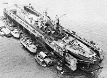
The US Navy forcibly moved the local islanders to another island for the duration of the use of their lagoon. Next up was Service Squadron 10, with its ships and floating docks. Within a month of the occupation of the atoll, an entire floating base was operational. Six thousand fitters, craftsmen, welders, joiners, electricians with floating dry docks were stationed in the atoll. The floating dry docks towed into the atoll were large enough to accommodate a 45,000-ton battleship . A fleet of tankers made it possible to refuel the warships not far from their areas of operation. The Japanese had assumed that the vast expanse of the Pacific Ocean would be very difficult for US operations with supplies . With the Ulithi naval base , many US ships were now able to deploy and operate in the western Pacific for a year or more without returning to the Pearl Harbor naval base . One large and several small airfields were built on the islands themselves . A recreation center for 8,000 soldiers and 1,000 officers was built on the island of Mogmog, including a theater with 1200 seats and a chapel with 500 seats. Recreational facilities have also been built on a number of larger islands.
The Japanese attempted a series of attacks on ships in the atoll from Yap on several occasions. On November 20, 1944, one-man torpedoes ( Kaiten ) launched from two nearby submarines were used to attack the ships in the atoll. The destroyer USS Case rammed and sank a kaiten. The tanker USS Mississinewa , anchored in the atoll, was hit and sank. It was not until February 2003 that a US Navy team carried out an action to get as much oil as possible from the wreck of the USS Mississinewa , as oil was still leaking there. A second Kaiten attack in January 1945 was foiled when I-48 , a Type C submarine , was sunk by destroyers. None of the 122 men on board the submarine survived.
On March 11, 1945, two long-haul aircraft attacked the naval base in a nightly kamikaze attack during Operation Tan No. 2 at. One plane hit the aircraft carrier USS Randolph . This resulted in moderate damage and a number of crew members were killed. The other machine only hit a baseball field.
On March 13, 1945, 647 ships were anchored in the atoll and shortly before the invasion of Okinawa , the number of ships in the roadstead reached a high of 722 ships. After the Gulf of Leyte in the Philippines was secured, the Pacific Fleet moved on to Leyte and the Ulithi base was abandoned. For seven months in late 1944 and early 1945, the great lagoon of Ulithi Atoll was the largest and most active anchorage in the world.
After the end of World War II, Ulithi Atoll became part of the US Pacific Islands Trust Territory .
Ulithi Atoll has belonged to the state of Yap of the Federated States of Micronesia since May 10, 1979, and became an integral part of this new state with its official independence on November 3, 1986. The Ulithi Atoll is one of 22 municipalities in the state of Yap.
Individual evidence
- ↑ www.oceandots.com - An image-based encyclopedia of islands ( Memento of December 23, 2010 in the Internet Archive ) (English)
- ↑ http://pacificweb.org/DOCS/fsm/1987%20Yap%20Census/yap87.pdf
- ↑ http://www2.census.gov/prod2/decennial/documents/00496492v1p54-58ch5.pdf
- ↑ James Burney: A Chronologic History of the Discoveries of the South Sea or Pacific Ocean . London: printed by Luke Hansard, 1817, ISBN 978-1-108-02411-2 .
- ↑ Brent Jones: Reporting For Duty . In: Mighty Ninety, The Homepage of USS Astoria CL-90 . December 2007. Retrieved July 15, 2012.
- ^ Building the Navy's Bases in World War II: History of the Bureau of Yards and Docks and the Civil Engineering Corps, 1940-1946 . Retrieved July 15, 2012.
- ^ Battle for Anguar and Ulithi (Operation Stalemate II) September 1944 . In: Military History Encyclopedia on the Web . Retrieved July 15, 2012.
- ↑ a b ServRon 10: Floating Arsenal . In: Popular Mechanics . November 1945, p. 59 .
- ↑ World Battlefronts: Mighty Atoll . In: Time . August 6, 1945. Retrieved July 15, 2012.
- ↑ http://www.supsalv.org/essm/ppt/MISS_Web_Summary.ppt#1 here
- ↑ Japanese submarine losses . Retrieved September 16, 2010.
- ^ Arnold, Bruce Makoto. An Atoll on the Edge of Hell: The US Military's Use of Ulithi During World War II. Unpublished MA Thesis, History. Sam Houston State University , 2007.


