Maap
| Maap | ||
|---|---|---|
|
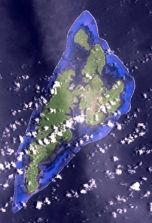
Satellite image of the Yap Islands (Maap top right) |
||
| Waters | Pacific Ocean | |
| Archipelago | Yap Islands | |
| Geographical location | 9 ° 35 '38 " N , 138 ° 9' 57" E | |
|
|
||
| length | 5.4 km | |
| width | 2.5 km | |
| surface | 10.64 km² | |
| Highest elevation | Doeweeliil 78 m |
|
| Residents | 592 (2000) 56 inhabitants / km² |
|
| main place | Bechiyal | |
| Map of the Yap Islands, with Maap to the northeast | ||
Maap is the third largest island in the Yap Islands , a small group of islands in the western Pacific . This is approximately 1300 km from New Guinea and 870 km from Guam .
The densely forested island lies between the islands of Rumung in the northwest and Gagil-Tomil in the south. It is separated from Rumung by the Yinbinaew inlet , which is 140 meters wide and 700 meters long , and from Gagil-Tomil by the Yunearawëy (Yuneroway) inlet, which is at least 66 meters wide and 2,100 meters long .
There is a permanent connection with Gagil-Tomil via an artificial roadway . Boat connections lead to the northern neighboring island of Rumung, mostly from the coastal town of Bechiyal .
At the 2000 census, 592 people lived in 115 households, a little more than in 1994 when 547 people lived in 114 households.
literature
- Erich Kaiser: Contributions to the petrography and geology of the German South Sea Islands. In: Yearbook of the Royal Prussian Geological State Institute and Mining Academy in Berlin for the year 1903. Volume XXIV, Berlin 1907, pp. 93–121. pdf
Individual evidence
- ↑ Yap State Census, 2000 (PDF; English; 2.9 MB)


