West Fayu
| West Fayu (Piagailoe) | ||
|---|---|---|
|
False Color Satellite Image of West Fayu Island appears red |
||
| Waters | Pacific Ocean | |
| archipelago | Carolines | |
| Geographical location | 8 ° 5 ' N , 146 ° 44' E | |
|
|
||
| Number of islands | 1 | |
| Main island | West Fayu Island | |
| length | 7.3 km | |
| width | 2.7 km | |
| Land area | 6.2 ha | |
| Lagoon area | 5.641 km² | |
| total area | 11 km² | |
| Residents | uninhabited | |
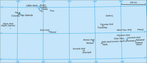
| Yap (state) with West Fayu to the east | ||
Piagailoe (also Piagailoe ) is an uninhabited atoll in the eastern part of the State of Yap of the Federated States of Micronesia and thus belongs to the archipelago of the Caroline Islands in the Pacific Ocean . To distinguish it from the atoll Fayu (East Fayu) belonging to the state of Chuuk and located over 500 km further east, the island name was given the prefix West .
geography
West Fayu is 71 km northeast of Lamotrek , 82 km northwest of Satawal and 945 km east of the main island of Yap . The atoll is at the western end of a long chain of submarine elevations that extend westward from the Gray Feather Bank for 180 kilometers, including the Condor Reef , Pikelot and Oraitilipu Bank .
West Fayu is a small atoll with a length of seven kilometers and consists of an approximately circular ring of reefs, with a diameter of 3.5 km. A side reef extends four kilometers to the northeast. In the southeast there is a shallow passage for boats into the lagoon .
The only island is the densely forested West Fayu Island (or Islet) at 8 ° 5 ′ 21 ″ N , 146 ° 44 ′ 28 ″ E in the northeast. The island has a land area of a good six hectares , while the lagoon measures 5.6 km². The total area is about 11 km². The lagoon is up to 38 meters deep.
administration
Piagailoe belongs to the municipality ( municipality ) Satawal . Satawal is 82 km southeast of West Fayu. The parish belongs to the fourth constituency of the state of Yap, one of the total of five constituencies.
Individual evidence
- ↑ Oceandots ( Memento of 23 December 2010 at the Internet Archive )
- ^ Otis W. Freeman, ed., Geography of the Pacific, Wiley 1953
- ↑ [1]
- ↑ PDF at www.fsmcongress.fm ( page no longer available , search in web archives ) Info: The link was automatically marked as defective. Please check the link according to the instructions and then remove this notice.
- ↑ http://www.pacificworlds.com/yap/home/location.cfm
- ^ Yap State Code, Title 7, Elections, §111 Election districts


