Faraulep
| Faraulep | ||
|---|---|---|
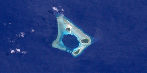
| NASA image of the atoll | ||
| Waters | Pacific Ocean | |
| archipelago | Carolines | |
| Geographical location | 8 ° 36 ' N , 144 ° 31' E | |
|
|
||
| Number of islands | 3 | |
| Main island | Nigaruyaru | |
| length | 4.1 km | |
| width | 3 km | |
| Land area | 42.2 ha | |
| Lagoon area | 2.336 km² | |
| total area | 7 km² | |
| Residents | 221 (2000) | |
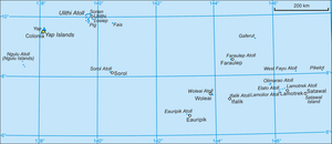
| Yap (state) with Faraulep in the east | ||
Faraulep or Faraulap is an atoll in the eastern part of the State of Yap of the Federated States of Micronesia and thus belongs to the archipelago of the Caroline Islands in the Pacific Ocean .
geography
Faraulep is 116 km southwest of Gaferut Island and 695 east-southeast of the main island of Yap . The atoll has an approximately square plan, with sides of 3 to 4 km, and a total area of 7 km². The wide reef rim encloses a small, deep lagoon , which only has an opening in the southwest. The atoll has three islands with a total area of over 40 hectares :
- Fuasubukoru ( 8 ° 36 '56 " N , 144 ° 32' 2" O ) , occupied, 10.2 ha
- Nigaruyaru ( 8 ° 36 '23 " N , 144 ° 32' 4" O ) , inhabited 20.2 ha
- Eate ( 8 ° 35 '14 " N , 144 ° 33' 0" O ) , uninhabited, 11.7 ha
The population was 221 at the 2000 census. It is distributed between the two villages of Nigaruyaru and Fuasubukoru on the islands of the same name.
administration
Faraulep is a town ( municipality ) of the State of Yap, is one of the island Gaferut. The parish belongs to the fourth constituency of the state of Yap, one of the total of five constituencies.
Individual evidence
- ↑ Oceandots ( Memento of 23 December 2010 at the Internet Archive )
- ^ Otis W. Freeman, Geography of the Pacific, Wiley 1953
- ↑ 2000 census of Yap (PDF; 2.9 MB)
- ↑ http://www.pacificworlds.com/yap/home/location.cfm
- ^ Yap State Code, Title 7, Elections, §111 Election districts


