
French frigate shoals
| French frigate shoals | ||
|---|---|---|
 |
||
| Waters | Pacific Ocean | |
| archipelago | Northwest Hawaii Islands | |
| Geographical location | 23 ° 46 ′ N , 166 ° 11 ′ W | |
|
||
| Number of islands | 13 | |
| Main island | Tern Island | |
| length | 37 km | |
| Land area | 25 ha | |
| Lagoon area | 450 km² | |
| Highest elevation |
La Perouse Pinnacle 36 m |
|
| Residents | uninhabited | |
 |
||

The French Frigate Shoals ( Hawaiian : Kānemilohaʻi ) are the largest atoll in diameter in the Northwestern Hawaiʻi Islands . It is located in the Pacific Ocean about 850 km northwest of Oahu , the most populous island in Hawaii .
geography
The atoll, which is open to the west and southwest, has a diameter of up to 37 kilometers. It consists of twelve small, sandy islets, which are mainly in the north of the atoll and are surrounded by a crescent-shaped coral reef over 30 km long . In the center of the atoll is the 36 m high and steep from the lagoon outstanding La Perouse Pinnacle , a remnant of the former and now almost completely submerged volcano . The total land area of all islands in the atoll is only 0.25 km² (248,914 m²), of which about half (105,276 m²) is on the largest island, Tern Island in the north of the French Frigate Shoals (at 23 ° 52 ′ N , 166 ° 17 ′ W ), not applicable. The nearest islands are Necker Island , about 160 km away in the southeast and the Gardner Pinnacles , which are about 230 km away in the northwest. Between the French Frigate Shoals and the Gardner Pinnacles are some deep sea mountains , such as the Brooks Bank or the St. Rogatien Bank .
Islands
The islands are listed clockwise, starting in the northwest, and ending with La Perouse Pinnacle, a little further away to the west :
![]() Map with all coordinates: OSM | WikiMap
Map with all coordinates: OSM | WikiMap
| Motu | Census block |
Area ( m² ) |
Coordinates |
|---|---|---|---|
| Shark Island | 1010 | 4294 | 23 ° 51 ′ 10 ″ N , 166 ° 19 ′ 26 ″ W. |
| Trig Island | 1008 | 23298 | 23 ° 52 ′ 18 " N , 166 ° 14 ′ 36" W. |
| Skate Island 1) | 1007 | 12808 | 23 ° 52'03 " N , 166 ° 13'54" W. |
| Whale Island 1) | 1007 | 19212 | 23 ° 52 '02 " N , 166 ° 13' 51" W. |
| Disappearing Island | 1002 | 9800 | 23 ° 38 ′ 40 " N , 166 ° 10 ′ 16" W. |
| Little Gin Island | 1003 | 19448 | 23 ° 43 ′ 44 " N , 166 ° 09 ′ 51" W. |
| Gin Island | 1004 | 9708 | 23 ° 44'04 " N , 166 ° 09'56" W. |
| Near Island 2) | - | 400 | 23 ° 48 '20 " N , 166 ° 13' 46" W. |
| Bare Island 3) | - | 400 | 23 ° 47 ′ 33 ″ N , 166 ° 12 ′ 06 ″ W. |
| East Island 4) | 1005 | - | 23 ° 47 '13 " N , 166 ° 12' 33" W. |
| Mullet Island 5) | 1006 | 2462 | 23 ° 49 ′ 29 ″ N , 166 ° 13 ′ 29 ″ W. |
| Round Island 5) | 1006 | 3078 | 23 ° 49 '36 " N , 166 ° 13' 46" W. |
| La Perouse Pinnacle | 1011 | 3677 | 23 ° 47'08 " N , 166 ° 12'46" W. |
1) Skate-Whale Island is currently a double island and is also shown in the census documents as one block with an area of 32020 m². The proportions of the sub-islands are estimated (40 and 60 percent respectively).
2) In 1971 it was reported that although Near Island was on maps, it would be flooded at high tide.
3) Bare Island can still be seen on satellite images, but is not (no longer) listed in the Census Tract . In a 1971 publication, Bare Island was given an area of 0.1 acres (approximately 400 m²).
4) East Island was the second largest island in the archipelago with an area of 35,853 m² before it was eroded by Hurricane Walaka in early October 2018 .
5) Mullet Island and Round Island are shown together in census documents as block 1006, with a total area of 5540 m². The proportions are estimated according to a report from 1971 (0.4 and 0.5 acres).
history
The islands were sighted on November 6, 1786 by the French explorer Jean-François de La Pérouse and named by him Basse des Fregates Françaises because his two frigates Boussole and Astrolabe were almost stranded on the reef.

On January 14, 1859, the French Frigate Shoals were taken for the United States , citing the Guano Islands Act . In contrast to the island of Laysan, however , the mining of guano was not profitable, so that human intervention in nature was only minor. On February 3, 1909, the atoll became part of the Hawaiian Islands Bird Reservation and in 2006 part of the Papahānaumokuākea Marine National Monument .
During World War II , the islands were of great importance because of their location halfway from Hawaii to the Midway Islands . For example, after the Battle of Midway, a runway was built on Tern Island that still exists today. The facilities on Tern Island are now managed by the United States Fish and Wildlife Service .
In 2018, East Island disappeared as Hurricane Walaka passed over it. The shape of the neighboring island of Tern Island was also changed by the cyclone.
Animal world (fauna)
The islands are one of the most important retreats for rare animal species in northwest Hawaii, for example for the Hawaiian monk seal ( Monachus schauinslandi ). Over 90% of the Hawaiian green turtle population ( Chelonia mydas ) migrates to the French Frigate Shoals for breeding.
- Wildlife

Hawai'i monk seal and laysanal bat on Tern Island

Seabird colony on Tern Island

Hard coral of the genus Acropora
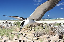
Flying sooty tern


The islands also provide an important colony for seabirds is: So breed here among other Laysan Albatross ( Phoebastria immutabilis ), black-footed albatross ( Phoebastria nigripes ), Brown Booby ( Sula leucogaster ) Frigate ( Fregata minor ) and various types terns like the Fairy Tern ( Gygis alba ) .
The coral reefs of the atoll are home to 41 species of hard corals ( Scleractinia ) including species of the genus Acropora that are not found anywhere else in Hawaii. Only here are fish like the rippled butterflyfish ( Chaetodon trifasciatus ), which are dependent on polyps of this type of hard coral. There are also other species of butterfly fish , such as the common banner fish ( Heniochus acuminatus ) and surgeon fish (Acanthuridae). A little outside the reefs, the gray reef shark ( Carcharhinus amblyrhynchos ) or the masked lyra angelfish ( Genicanthus personatus ) can be found.
An expedition of the National Oceanic and Atmospheric Administration (NOAA) to the French Frigate Shoals in October 2006 discovered over 100 species new, or new for Hawaii, in just three weeks.
Web links
- French Frigate Shoals Web Page (English)
- NOAA research trip to the French Frigate Shoals (English)
- Census Block Map (PDF; 91 kB)
- The French Frigate Shoals in CoRIS ( Memento from November 5, 2014 in the Internet Archive )
Individual evidence
- ↑ United States Census Bureau, French Frigate Shoals: Blocks 1002 thru 1011, Census Tract 114.98, Honolulu County, Hawaii (English)
- ↑ PDF at www.statecountymaps.com ( Memento from June 22, 2015 in the Internet Archive )
- ^ A. Binion Amerson Jr.: The Natural History of French Frigate Shoals, Northwestern Hawaiian Islands. Atoll Research Bulletin No. 150, 1971 , page 28: Bare Island ... is awash at high tide and is usually about 100 feet long, 10 feet wide, and 4 feet high. It covers an area of 0.1 acre. Wetmore (ms.) In 1923 described it as "60 yards long by 10 wide, merely a ridge of sand rising 5 feet above the water and evidently swept" by waves.
- Jump up ↑ Hurricanes: Hurricane erases Hawaii Island from map . ( Spektrum.de [accessed October 27, 2018]).
- ↑ a b Oliver Milman: Hawaiian island erased by powerful hurricane: 'The loss is a huge blow'. In: The Guardian . October 24, 2018, accessed October 25, 2018 .
- ↑ Jane's Oceania Page - French Frigate Shoals (English)
- ↑ NWHI Multi-Agency Education Project: about French Frigate Shoals ( Memento of the original of February 13, 2007 in the Internet Archive ) Info: The archive link was automatically inserted and not yet checked. Please check the original and archive link according to the instructions and then remove this notice. (English)
- ↑ NWHI Multi-Agency Education Project: Census of Coral Reefs Expedition to French Frigate Shoals ( Memento of the original from September 28, 2007 in the Internet Archive ) Info: The archive link was automatically inserted and not yet checked. Please check the original and archive link according to the instructions and then remove this notice. (English)
The eight main islands: Hawaii | Kahoʻolawe | Kauaʻi | Lānaʻi | Maui | Molokaʻi | Niʻihau | Oahu
Smaller islands: Ālau | Kapapa | Kaʻula | Kekepa | Lehua | Mānana | Mōkapu | Mōkōlea | Mokoliʻi | Mokuʻauia | Mokuʻaeʻae | Moku Manu | Molokini | Nā Mokulua | Poʻopoʻo
Northwestern Hawaiian Islands : French Frigate | Gardner | Cure | Laysan | Lisianski | Maro Reef | Necker | Nihoa | Pearl and Hermes