Molokini
| Molokini | ||
|---|---|---|
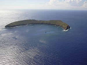
| Aerial view of Molokini | ||
| Waters | ʻAlalākeiki Channel, Pacific Ocean | |
| Archipelago | Hawaii | |
| Geographical location | 20 ° 37 '51 " N , 156 ° 29' 43" W | |
|
|
||
| length | 620 m | |
| width | 115 m | |
| surface | 9.317 ha | |
| Highest elevation | 55 m | |
| Residents | uninhabited | |
Molokini is a small uninhabited island between Maui and Kahoolawe in the archipelago of Hawaii . It is located 4.2 km west of Maui and 6.9 km northeast of Kahoʻolawe.
The crescent-shaped island, which was formed 150,000 years ago, represents the crater rim of an extinct volcano and has an area of only 9.317 hectares (0.093 km²). During World War II , Molokini was used as a bomb training target; today the island is a popular Hawaiian diving destination . Because of the numerous seabirds , the island, like many other small islands in Hawaii, is a Hawaii State Seabird Sanctuary ( bird sanctuary ) and may not be entered.
Individual evidence
- ↑ [1]
- ↑ United States Census Bureau, Molokini: Block 9000, Block Group 9, Census Tract 303.02, Maui County, Hawaii (English)
Web links
Commons : Molokini - collection of images, videos and audio files
- Molokini , Hawaii Tourism Authority
- Molokini in Offshore Islet Restoration Committee (English)
literature
- Harold Schjoth Palmer: Geology of Molokini, Honolulu 1930 (= Bernice P. Bishop Museum Occasional Papers Vol. IX, No. 1)

