Necker Island (Hawaii)
| Necker Island | ||
|---|---|---|
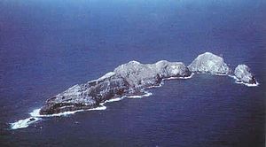
| Aerial view of Necker Island | ||
| Waters | Pacific Ocean | |
| Archipelago | Northwest Hawaii Islands | |
| Geographical location | 23 ° 34 '30 " N , 164 ° 42' 5" W | |
|
|
||
| length | 1.2 km | |
| width | 200 m | |
| surface | 18.3 ha | |
| Highest elevation |
Summit Hill 84 m |
|
| Residents | uninhabited | |
| Map of Necker Island | ||
Necker Island ( Hawaiian : Mokumanamana ) is a small, uninhabited island in the Pacific Ocean , which geographically belongs to the Northwest Hawai'i Islands and politically to the US state of Hawaii . It lies within the Papahānaumokuākea Marine National Monument , which was proclaimed in 2006 and is currently the largest marine nature reserve in the world.
geography
Necker Island is only 13 km north of the tropic and is about 300 km northwest of the neighboring island Nihoa and 690 km northwest of Honolulu on Oahu . The crescent-shaped island is about 1200 m long, maximally 200 m wide and has an area of only 0.183 km². There are five hills, of which Summit Hill is the highest at 84 m. On the mostly dry, rocky surface there are only five different types of low-growing plants.
Like all the islands in the Hawai'i chain of islands, Necker is of volcanic origin.
history
The first European to discover the island was the French explorer Jean-François de La Pérouse on November 4, 1786 . He christened it Île Necker , after the then French finance minister Jacques Necker , but could not enter the island because of bad seas. In 1857 the island was formally taken over by the Hawaiian King Kamehameha IV , but the island was not finally annexed until May 27, 1894 when the Hawaiian flag was hoisted .
The most important scientific expedition to Necker Island took place in 1923-24 under the name Tanager Expedition .
As on Nihoa, artifacts of early human settlement have also been found on Necker Island . There are 33 stone shrines to which a religious meaning is ascribed. In addition, more than eleven petroglyphs , so-called kiʻi pohaku, were found. Due to the obvious uses of the island for ceremonial and religious purposes, it was listed as a Historic District on June 13, 1988 in the National Register of Historic Places , the register of the historically significant places of the United States.
Today, Necker Island may only be entered for scientific purposes with special permission from the US Fish & Wildlife Service .
Animal world (fauna)
The island is home to various sea birds , such as the blue noddy ( Procelsterna cerulea ), as well as numerous marine animals such as the gray reef shark ( Carcharhinus amblyrhynchos ) or the Hawaiian monk seal ( Monachus schauinslandi ). There are several species of sea cucumbers and sea urchins in Shark Bay .
Web links
Individual evidence
- ↑ United States Census Bureau, Necker Island: Block 1001, Census Tract 114.98, Honolulu County, Hawaii (English)
- ↑ Janes' Oceania Page - Necker Island (English)
- ↑ Tanager Expedition (English)
- ↑ a b NWHI Multi-Agency Education Project: about Mokumanamana ( Memento of the original from June 18, 2009 in the Internet Archive ) Info: The archive link was inserted automatically and has not yet been checked. Please check the original and archive link according to the instructions and then remove this notice. (English)
- ^ Necker Island Archeological District in the National Register Information System. National Park Service , accessed August 8, 2017.


