
Lehua
| Lehua | ||
|---|---|---|
 |
||
| Waters | Pacific Ocean | |
| Archipelago | Hawaii | |
| Geographical location | 22 ° 1 '12 " N , 160 ° 5' 51" W | |
|
||
| length | 1.8 km | |
| width | 1.5 km | |
| surface | 1.03 km² | |
| Highest elevation | Kaunuakalā 213 m |
|
| Residents | uninhabited | |
 |
||

Lehua is a small, uninhabited island in the archipelago of Hawaii . It is located 1.1 km from Puʻukole Point , the northernmost point of Niʻihaus and, like this one, belongs to Kauai County . Lehua is also the name of a traditional chieftainship ( ahupuaʻa ) in the north of the island of Niʻihau, which also includes the island of Lehua in its area of 179.9 km².
The crescent-shaped island represents the crater rim of a former volcano rising steeply from the Pacific . It rises up to 213 meters above sea level and covers an area of 1.03 km². The United States Coast Guard operates a lighthouse, Lehua Rock Light, on the highest point on the island, Kaunuakalā . The lighthouse originally built in 1932 was replaced by a solar- powered one in 1989 . Like almost all Hawai'i islands, Lehua is already shrinking again due to erosion .
The chiefdom of Lehua had a larger area on the island of Niihau and covered 7.93 km².
Flora and fauna
22 different plant species were identified on the sparsely vegetated surface of the island. Since rabbits introduced over 70 years ago cause severe damage to the plant population, there are efforts to eradicate the rabbits on Lehua. The island is also an important breeding area for seabirds : seven species breed on the island, and another 17 species regularly visit the island. The most important breeding birds include the brown booby ( Sula leucogaster ), whose colony on Lehua is one of the largest in Hawaii, as well as the red-footed booby ( Sula sula ), the black-footed albatross ( Phoebastria nigripes ) and the shearling ( Puffinus pacificus ). Lehua is, like many other small islands in Hawaii, a Hawaii State Seabird Sanctuary ( bird sanctuary ) and may not be entered.
Cultural meaning
Because of its western location, the island is associated with sunset in Hawaiian culture and a breeze is named after it. In poetry, the island is used together with the easternmost point on Hawai'i , Cape Kumukahi , as an expression for the extent of the archipelago.
Picture gallery

Lehua as seen from Ni'ihau

Lehua seen from the west
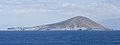
From the sea a western view of Lehua


Individual evidence
- ↑ Map of the traditional ahupuaʻas of Niʻihau
- ↑ Original information: 1,959 acres
- ^ Lehua in Hawaiian Dictionaries
- ↑ welo (2nd) in Hawaiian Dictionaries : "Mai ka ʻōmaka ʻana o ka lā ma Kumu-kahi ā ka welo ʻana a ka lā i Lehua" (from the rising of the sun at Kumu-kahi to the setting of the sun at Lehua )
Web links
- Lehua in Offshore Islet Restoration Committee (English)
- United States Coast Guard LighthouseLists (English; PDF file; 134 kB)
literature
- Harold Schjoth Palmer: Geology of Lehua and Kaula Islands (= Bernice P. Bishop Museum Occasional Papers XII, 13)
The eight main islands: Hawaii | Kahoʻolawe | Kauaʻi | Lānaʻi | Maui | Molokaʻi | Niʻihau | Oahu
Smaller islands: Ālau | Kapapa | Kaʻula | Kekepa | Lehua | Mānana | Mōkapu | Mōkōlea | Mokoliʻi | Mokuʻauia | Mokuʻaeʻae | Moku Manu | Molokini | Nā Mokulua | Poʻopoʻo
Northwestern Hawaiian Islands : French Frigate | Gardner | Cure | Laysan | Lisianski | Maro Reef | Necker | Nihoa | Pearl and Hermes