
Mokuʻauia
| Mokuʻauia | ||
|---|---|---|
 |
||
| Waters | Pacific Ocean | |
| Archipelago | Hawaii | |
| Geographical location | 21 ° 39 '47 " N , 157 ° 55' 22" W | |
|
||
| length | 500 m | |
| width | 330 m | |
| surface | 5.3 ha | |
| Highest elevation | 6 m | |
| Residents | uninhabited | |

Mokuʻauia (also Moku ʻAuia or English Goat Island , "goat island" called) is a flat, uninhabited island in the archipelago of Hawaii in the Pacific Ocean . It is located on the edge of Lāie Bay about two hundred meters off the northeast coast of the island of Oahu and administratively belongs to Honolulu County .
The island is a maximum of 6 m high, surrounded by coral reefs , 500 m long, up to 330 m wide and has an area of 5.3 ha (0.053 km²). The island, which consists mainly of limestone , is an important breeding area for the wedge-tailed shearwater ( Puffinus pacificus , Hawaiian ʻuaʻu kani or hōʻio ) with over 6500 specimens . Mokuʻauia is therefore, like many other small islands in Hawaii, a Hawaiʻi State Seabird Sanctuary ( bird sanctuary ) and may not be entered. Since the flat island is regularly exposed to the saltwater spray, only a few indigenous plants can be found there , including the rare and endangered Sesbania tomentosa , Hawaiian: ʻ , hai , a species of the butterfly family .
- Views
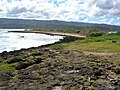
Mokuʻauia's coast, in the background the island of Oʻahu

Seabird sanctuary billboard
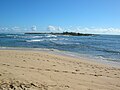
Mokuʻauia seen from Oʻahu


Web links
- Mokuʻauia in the Geographic Names Information System of the United States Geological Survey
- Moku'auia in Offshore Islet Restoration Committee (English)
Individual evidence
- ↑ hōʻio in Hawaiian Dictionaries , ʻuaʻu kani in Hawaiian Dictionaries
- ↑ ʻōhai in Hawaiian Dictionaries
The eight main islands: Hawaii | Kahoʻolawe | Kauaʻi | Lānaʻi | Maui | Molokaʻi | Niʻihau | Oahu
Smaller islands: Ālau | Kapapa | Kaʻula | Kekepa | Lehua | Mānana | Mōkapu | Mōkōlea | Mokoliʻi | Mokuʻauia | Mokuʻaeʻae | Moku Manu | Molokini | Nā Mokulua | Poʻopoʻo
Northwestern Hawaiian Islands : French Frigate | Gardner | Cure | Laysan | Lisianski | Maro Reef | Necker | Nihoa | Pearl and Hermes