Tern Island (Hawaii)
| Tern Island | ||
|---|---|---|
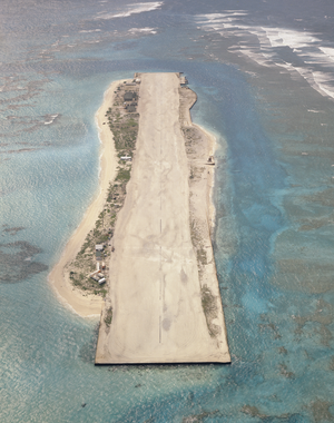
| Aerial photo from 1961 | ||
| Waters | Pacific Ocean | |
| Archipelago | French Frigate Shoals ( Northwestern Hawaiian Islands ) | |
| Geographical location | 23 ° 52 '10 " N , 166 ° 17' 6" W | |
|
|
||
| length | 1 km | |
| width | 150 m | |
| surface | 10,527 6 ha | |
| Residents | uninhabited | |
Tern Island ( English for " Tern Island") is a coral island in the northwest of the French Frigate Shoals and the main island of this atoll in the northwestern Hawaiian Islands . It belongs to the US state of Hawaii .
history
After the Battle of Midway, an approximately 1000 meter long airfield (" Airfield French Frigate Shoals ") was built on the island . After the end of World War II, there was a manned radio navigation station ( LORAN ) of the US Coast Guard on Tern Island until 1979 . The station was previously, until 1952, built on neighboring East Island .
According to the 2000 census, the island had an area of exactly 105,276 m², without permanent residents.
Web links
Commons : Tern Island - collection of pictures, videos and audio files
Individual evidence
- ↑ French Frigate Shoals on the Papahānaumokuākea Marine National Monument website
- ↑ United States Census Bureau, French Frigate Shoals: Blocks 1002 thru 1011, Census Tract 114.98, Honolulu County, Hawaii

