
Rangiroa
| Rangiroa | ||
|---|---|---|
 |
||
| Waters | Pacific Ocean | |
| archipelago | Tuamotu Archipelago | |
| Geographical location | 15 ° 8 ′ S , 147 ° 39 ′ W | |
|
||
| Number of islands | about 240 | |
| Main island | Avatoru | |
| Land area | 79 km² | |
| Lagoon area | 1 600 km² | |
| Residents | 2438 (2007) | |
_(20157828330).jpg) |
||

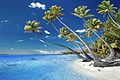
Rangiroa is the largest atoll in the Tuamotu Archipelago in French Polynesia . Rangiroa is also called Ra'iroa (translated: "wide sky") because of the clarity and width of the lagoon .
geography

Rangiroa is located in the southern Pacific Ocean about 350 km northeast of Tahiti .
The atoll is 80 km long and between 5 and 32 km wide. The approximately 1600 km² large lagoon has a maximum depth of 35 m. It is surrounded by a ring of 240 motus (islands, total land area 79 km²) and about 100 narrow passages. In the north-west, near the villages, there are two deeper passages suitable for navigation. Rangiroa is the second largest atoll in the world after Kwajalein .
administration
Rangiroa is a " Commune associée " (sub-municipality) of the municipality of Rangiroa . In the northwest of the atoll are the villages Avatoru and Tiputa (main town with the local administration and the post office). There is a small airport ( IATA airport code RGI) between these villages, 10 km away .
population

After the census of 2002, the 2,334 inhabitants distributed in three villages:
- Tiputa (971)
- Avatoru (817)
- Ohotu (546)
They live from tourism , fishing (for export to Tahiti ), pearl fishing and copra . Rangiroa has a well-developed tourist infrastructure for the Tuamotus and is very popular with scuba divers . The political municipality of Rangiroa also includes the atolls Mataiva and Tikehau and the island of Makatea .
history
Rangiroa was probably settled by Polynesians around the 10th century . It was discovered on April 18, 1616 by the Dutchman Jacob Le Maire ; the first Europeans inhabited the atoll from 1851.
traffic
The Rangiroa Airport is situated 5.5 kilometers southeast from the village of Avatoru and can compete with its 2.1 km long slope next to private aircraft and smaller commercial aircraft. Roads for car traffic are only in and around the three villages in the north, the remaining parts of the island are sparsely populated or uninhabited and separated from each other by the numerous sea entrances; the most important means of transport here is the boat. The atoll is visited from time to time by cruise ships that bring their passengers ashore in motorized inflatable boats.
- Views

West part of Rangiroa, the lagoon is on the right

Passage into the lagoon at Avatoru

Pearl farm workers

One of the innumerable motus
One of the uninhabited motus
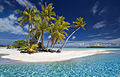
Blue Lagoon

Local huts next to the blue lagoon

Shark feeding in the blue lagoon


See also
literature
- Elisabeth Worliczek: Ethnography of Climate Change: The different perception and interpretation of environmental changes on a high island (Wallis) and an atoll (Rangiroa) in the francophone South Pacific. In: Pacific Dossier. 9.2010, pp. 13–63 online edition
Web links
- Page about Rangiroa with more pictures (french)
- Rangiroa on oceandots.com ( Memento from December 23, 2010 in the Internet Archive ) (English)
- Map of Rangiroa
- Map of the atoll (PDF)
- Main Island Map (PDF)
Ahe | Ahunui | Akiaki | Amanu | Anaa | Anuanuraro | Anuanurunga | Apataki | Aratika | Arutua | Faaite | Fakahina | Fakarava | Fangatau | Fangataufa | Hao | Haraiki | Héréhérétué | Hikueru | Hiti | Katiu | Kauehi | Kaukura | Makatea | Makemo | Manihi | Manuhangi | Maria Est | Morocco | Marutea North | Marutea Sud | Mataiva | Matureivavao | Morane | Motutunga | Mururoa | Napuka | Nengonengo | Niau | Nihiru | Nukutavake | Nukutepipi | Paraoa | Pinaki | Puka-puka | Puka Rua | Rangiroa | Raraka | Raroia | Ravahere | Reao | Reitoru | Rekareka | Taenga | Tahanea | Taiaro | Takapoto | Takaroa | Takume | Tatakoto | Tauere | Tekokota | Tematangi | Temoe | Tenararo | Tenarunga | Tepoto North | Tepoto Sud | Tikehau | Tikei | Toau | Tuanake | Tureia | Vahanga | Vahitahi | Vairaatea | Vanavana