Temoe
| Temoe | ||
|---|---|---|
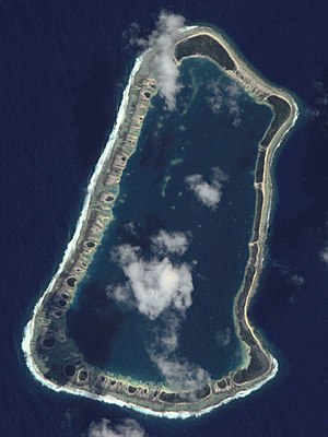
| NASA image of Temoe | ||
| Waters | Pacific Ocean | |
| archipelago | Gambier Islands | |
| Geographical location | 23 ° 21 ′ S , 134 ° 29 ′ W | |
|
|
||
| Number of islands | 16 | |
| Main island | Omeniʻi | |
| Land area | 2.1 km² | |
| Lagoon area | 13.1 km² | |
| total area | 20 km² | |
| Residents | uninhabited | |
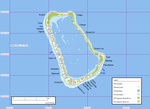
| Map of Temoe | ||
Temoe , also Timoe , old name: Crescent Island, is a small atoll in the southern Pacific Ocean . It is the southernmost atoll in French Polynesia and one of the most southern atolls on earth. Geographically, the island belongs to the Tuamotu Archipelago , more precisely to the Gambier Islands , and is located about 50 km from the nearest inhabited main island Mangareva . Temoe is not permanently inhabited and is administered by the municipality of Gambier of the administrative subdivision des Tuamotu-Gambier of the High Commission of French Polynesia ( Haut-commissariat de la République en Polynésie française ).
geography
The atoll consists of a ring of around 40 motus , which enclose a lagoon with an area of 13.1 km². The lagoon is quite shallow, only 13 m deep on average, and speckled with a number of coral rocks, some of which reach the surface of the water. Numerous Hoa ensure the exchange of water between the lagoon and the open ocean , especially on the south and south-west side. However, the tidal channels are too shallow to allow boat traffic. Only two Hoa in the northwest and west are restrictedly navigable when the water levels are high.
The land area of all islands together is only 2.1 km².
geology
Like all atolls, Temoe owes its existence to volcanism. The approximately 15 million year old basaltic base of the island rises from a depth of 3700 m below sea level. Temoe forms a chain of islands with Oeno , Henderson, and Ducie , all of which likely emerged from the same hotspot . The central island, which consists of volcanic rocks, has long since sunk below the surface of the sea, so that only the motus on the coral reef protrude.
flora
The motus consist of sand and coral debris and are poor in humus. The soil therefore offers plants only a few nutrients, so that the flora is not very rich in species. The areas near the beach are covered by creeping Triumfetta procumbens . The adjacent vegetation consists mainly of Suriana maritima and Pandanus . In the inner, slightly raised areas, Scaevola and Pemphis acidula also thrive , dominated by coconut palms . Wilson saw no coconut palms on the island in 1797, nor did Lucett in 1842. The palms growing there today were planted by returnees from neighboring Mangareva in the second half of the 19th century.
history
see also → History of the Gambier Islands
Numerous relics of the Polynesian natives prove that Temoe was once inhabited, some of which, although not restored, can still be recognized by today's visitor. The American anthropologist and curator of the Bernice P. Bishop Museum in Honolulu, Kenneth P. Emory (1897-1992), was the first scholar to examine and describe the buildings of the early Polynesians during a two-day stay on Temoe in 1934.
One of the legacies of the Polynesians that can still be seen is a four-tiered temple platform ( marae ) made of unprocessed coral blocks , which the New Zealand anthropologist Peter Buck ( Te Rangi Hīroa ) photographed as early as the 1930s. Buck describes the marae as an open courtyard with a towering stone platform stepped at the front and (burial?) Chambers at both ends. Today the complex is in a much worse state of preservation than in 1934 and looks more like a disordered collection of stones about 2½ m high. Peter Buck assumed that Temoe had been settled by refugees from Mangareva.
In an excavation campaign from 2001 to 2003, French archaeologists recorded the remains of a total of 13 ceremonial platforms on the islands. They also excavated an extensive cemetery on Motu Omenii Nui, a somewhat larger fringing island in the southwest, in which men, women and children were buried. The graves were marked with pyramids made of loosely stacked, unworked stones. No grave goods were found, except for a few fishhooks made from mussel shells. The radiocarbon dating showed that the cemetery from 1410 to 1650 n. Chr was used..
University of Queensland archaeologist Marshall Weisler analyzed piles of trash from several settlements. The remains suggested that Native Polynesian people mainly fed on seabirds, the Pacific rat (Rattus exulans), snails, clams, gastropods, and fish. The most common species of fish consumed were parrot fish . Human bones in the garbage heap suggest that cannibalism also existed. In the early 19th century the settlements were abandoned.
In 1637 the pirate Edward Davis set out with his ship Bachelors Delight from the Galapagos Islands to circumnavigate Cape Horn and sail to the Caribbean . He passed a flat and sandy island surrounded by reefs, which from then on appeared on the maps as Davisland (Terra de Davis). The Scottish-New Zealand philologist and university professor John Macmillan Brown assumed that the lost Davisland was the island of Temoe. There is no confirmation of this.
Temoe discovered Captain James Wilson for Europe, who went to the South Pacific on the Duff of the London Missionary Society . On the morning of May 23, 1797, a flat island in the shape of a crescent moon came into view, which Wilson named "Crescent Island" because of its appearance. When the Duff approached the following day, no navigable passage into the lagoon could be seen. Wilson himself got into a dinghy with four sailors and a native of Tahiti, provided with a few presents, to land on the ocean side despite the strong surf. As the boat headed for the island, about 25 islanders armed with spears gathered on the beach, including three or four women. They took a threatening stance to prevent the Europeans from landing. Wilson then stopped the landing maneuver and returned to the ship. He couldn't see breadfruit trees, coconut palms or canoes on the island, so he wondered how people could exist on the tiny island.
The first European to set foot on Temoe was the English naturalist and malacologist Hugh Cuming . He reached the island on December 6, 1827 with his research yacht The Discoverer . The crew brought out a dinghy to go ashore. The Europeans armed with muskets were already waiting on the beach by numerous warriors whose bodies were painted black and white and who wielded long spears. Cuming found a slip through in the reef, but had to pull the boat into the lagoon because numerous sharp-edged coral rocks blocked the passage. The islanders gestured for him to go ashore, but arming them made it inadvisable. The warriors then took a threatening stance and circled the boat. The Europeans fired a few warning shots in the air and when this had no effect, Cuming preferred to retreat. However, the natives capsized the boat and Cuming fell overboard. The crew managed to get the boat back upright and everyone was able to get to safety on the anchored yacht.
In 1838 the Catholic missionaries of the French order "Pères et religieuses des Sacrés-Cœurs de Picpus" (Picpusiens for short, in Germany Arnstein Fathers ) evacuated all residents of Temoe to Mangareva. It is controversial whether they were abused as workers for the construction of the Cathédrale Saint-Michel in Rikitea , known as the “South Sea Cathedral”, or whether they voluntarily left their island because of the poor living conditions. The construction of the church lasted from January 17, 1839 (laying of the foundation stone) to April 1841.
The British-Tahitian trader Edward Lucett (1815-1853), who passed Temoe in November 1842, describes the island as already uninhabited.
". . . although indicated on the maps as inhabited, that is long gone. The residents have fled to the Gambier Islands from extreme poverty and lack of food. "
In 1871, Père Laval, the head of the Picpus missionary station on Mangareva, had to leave the Gambier Islands at the behest of the Bishop of Tahiti. At the end of the 19th century, some families from Mangareva returned to Temoe and planted coconut palms. Today Temoe is uninhabited again, but Mangarevans visit the island from time to time to harvest coconuts.
Individual evidence
- ↑ a b c Paolo A. Pirazzoli: A reconnaissance and geomorphological survey of Temoe Atoll, Gambier. Islands (South Pacific). In: Journal of Coastal Research, Vol. 3, 1987
- ^ A b James Wilson: A Missionary Voyage to the southern Pacific Ocean. . . T. Chapman London, 1799 ( online )
- ↑ a b Edward Lucett: rovings in the Pacific, from 1837 to 1849; with a glance at California. Longman, Brown, Green, and Longmans, London, Volume 1
- ↑ Kenneth P. Emory: Archeology of Mangareva and neighboring atolls. Bernice P. Bishop Museum Bulletin No. 163, Honolulu 1939
- ^ Peter Buck ( Te Rangi Hīroa ): Vikings of the Sunrise. Whitcombe and Tombs Limited, Christchurch 1964, p. 210
- ^ Pascal Murail & Eric Conte: Les sépultures de l'atoll de Temoe (archipelago of the Gambier). Les Dossiers d'Archéologie Polynésienne No. 4, Tahiti 2005, pp. 164–172 (PDF; 917 kB)
- ^ Marshall I. Weisler: Contraction of the Southeast Polynesian Interaction Sphere and Resource Depression on Temoe Atoll. New Zealand Journal of Archeology 2004, Vol. 25 (4)
- ^ John Macmillan Brown: The Riddle of the Pacific. T. Fisher Unwin, London 1924
- ^ Peter Dance: Hugh Cuming (1791-1865) Prince of collectors. In: Journal of the Society for the Bibliography of Natural History, Vol. 9 (4) 1980, p. 480


