Matureivavao
| Matureivavao | ||
|---|---|---|
| NASA image by Matureivavao | ||
| Waters | Pacific Ocean | |
| archipelago | Actéon Islands , Tuamotu Archipelago | |
| Geographical location | 21 ° 29 ′ S , 136 ° 25 ′ W | |
|
|
||
| Number of islands | - | |
| Land area | 3.96 km² | |
| Lagoon area | 18 km² | |
| total area | 28.62 km² | |
| Residents | uninhabited | |
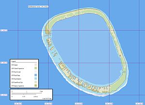
| Map of the atoll | ||
Matureivavao (old name: Melbourne Island ) is an atoll in the Tuamotu Archipelago in French Polynesia . Matureivavao is the easternmost and largest atoll of the Actéon Islands . Matureivavao is located 15 km west of Marutea Sud and 15 km southeast of Vahanga , the lagoon of the atoll has no navigable entrance to the sea. Administratively, Matureivavao belongs to the municipality of Gambier .
The total area is 28.62 km² (land area, reef and lagoon).
There are a few houses on Matureivavao, but it is not inhabited. In bad weather the sea sloshes over the atoll. The sandy beach of the atoll is bordered by lush vegetation.
swell
- ↑ http://www.issg.org/CII/PII/Printer%20friendly%20pages/final.restoration.vahanga.atoll_5ffinal.pdf
- Sailing Directions, Pub 126, Pacific Islands NIMA 2002 ; page 12
Web links
- Image and short description (Engl.) ( Memento of 23 December 2010 at the Internet Archive )
- Bird world of the atoll
- Fauna and flora of the atoll (PDF)


