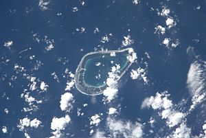
Tenarunga
| Tenarunga | ||
|---|---|---|
| NASA image of Tenarunga | ||
| Waters | Pacific Ocean | |
| archipelago | Tuamotu Archipelago | |
| Geographical location | 21 ° 21 ′ S , 136 ° 32 ′ W | |
|
|
||
| Number of islands | - | |
| Land area | 2.3 km² | |
| Lagoon area | 5 km² | |
| Residents | uninhabited | |
| map | ||
Tenarunga (old name: Minto Island ) is an uninhabited atoll in the Tuamotu Archipelago in French Polynesia . It belongs geographically to the Actéon Islands and administratively to the municipality of Gambier . The atoll is located 15 km northwest of Matureivavao and 6 km east of Vahanga . The island's 5 km lagoon has no access to the sea.
Tenarunga was discovered on February 5, 1605 by the Portuguese navigator Pedro Fernández de Quirós .
literature
- Sailing Directions, Pub 126, "Pacific Islands" NIMA 2002; page-12
Web links
- Image and short description (Engl.) ( Memento of 23 December 2010 at the Internet Archive )
- Volgewelt of the Atoll
- Fauna and flora of the atoll (PDF)


