
Mataiva
| Mataiva | ||
|---|---|---|
 |
||
| Waters | Pacific Ocean | |
| archipelago | Tuamotu Archipelago | |
| Geographical location | 14 ° 53 ′ S , 148 ° 31 ′ W | |
|
||
| Main island | Tohiraumati | |
| Land area | 16 km² | |
| Lagoon area | 25 km² | |
| Residents | 280 (2012) | |
 |
||

Mataiva or Matahiva , old name: Lasarev , is the northwesternmost island of the Tuamotu Archipelago and geographically belongs to the group of Palliser Islands (Îles Palliser).
geography
The atoll with a diameter of 8.5 by 3.6 kilometers has a shallow lagoon that covers 25 km². The volcanic central island of the geologically very old atoll has already sunk. The last remnant of the lagoon is the so-called "pito" (Polynesian for navel), a black basalt monolith that is only a few square meters in size and clearly stands out from the surrounding coral rock and sand. An oval, almost closed ring of islands encompasses the lagoon, which is already largely filled with sediment and which is divided into several "basins" by coral reefs that reach almost to the surface. It is only partially navigable with small boats, there is no navigable reef passage.
flora
The soils of the Motus, made up of coral sand and debris, are poor in nutrients. The vegetation of the flat Tuamotu Islands is not very biodiverse. The flora of Mataiva was decisively changed in the late 19th and early 20th centuries by the large-scale plantation of coconut plantations. Although many of the plantations have since been abandoned because of the decline in the price of copra , the coconut palm is still the plant that dominates the landscape today.
Remnants of the original vegetation are only preserved on a few small motus that separate the tidal channels ( Hoa ) from each other. It corresponds to the typical composition also found on other lower atolls of the Tuamotus. The beach vegetation consists of creeping plants as well as bushy Guettarda speciosa and Scaevola taccada . The forest adjoining inland consists mainly of Pisonia grandis , Pemphis acidula , Heliotropium foertherianum (synonym: Tournefortia argentea) , coconut palms and pandanus trees.
history
The inhabitants belong to the Mihiroa language group, which is etymologically more associated with Tahiti than with Paumotu, which is spoken on the rest of the Tuamotu Islands. This could be an indication that the far north of Mataiva was once settled from Tahiti. The time of the initial settlement is not known.
Proof of an early settlement of Mataiva by Polynesians is the Marae Papiro (or Marae of Tù), a ceremonial complex of unknown age on a headland near Tevaihara in the southeast of the atoll, directly on a Hoa . It was built from flat, vertical coral plates 30 to 60 cm high. The structure consists of eight separate, rectangular fields of different sizes. The center of the facility is a field, 16.70 m long and 8.80 m wide, delimited with stone slabs, inside a stone seat with a one meter high backrest and two armrests. According to legend, this is the throne of the mythical giant and king Tù, who was able to cross the entire island in three steps. Opposite, on the Motu Taae, you can still see some scattered stone slabs, remains of the Marae Taae, which once measured 12.30 x 5.30 m.
On July 30, 1820, the atoll was discovered for Europe by Fabian Gottlieb von Bellingshausen . He named the island "Lazarev" (also spelled "Lazarev") after Mikhail Petrovich Lasarew , the captain of his frigate Mirniy .
At the beginning of November 1835 Charles Darwin also visited the Mativa Atoll during his world tour with the Beagle . The knowledge gained here influenced his theory published in 1842 about the formation of the atolls.
Today Mataiva is a sub-municipality ( Commune associée ) of the municipality Rangiroa and politically belongs to French Polynesia .
Infrastructure
Mataiva has 280 inhabitants (as of 2012). The only village Pahua is in the northwest of Mataiva, on both sides of the inaccessible reef passage Passe Faratue , which cuts through the atoll ring for about a kilometer and which is less than 60 meters wide at the narrowest point. The two parts are connected by a concrete footbridge built in 1997/98, at 120 meters the longest bridge in Polynesia. Mataiva has had an airfield since 1999 ( ICAO code: NTGV, IATA code: MVT) with a 1,300 m (3,936 ft.) Runway, which can be reached by small Air Tahiti aircraft in a 1½ hour flight from Papeete . The airfield is located immediately west of the southern part of Pahua on the side of the island facing the open sea. The tourist infrastructure is underdeveloped. There is no hotel, only two private guesthouses, but no restaurant and no bank.
The inhabitants live mainly from subsistence farming , fishing with fish traps still plays an important role in obtaining food. Export goods are vanilla pods from a small plantation in the interior of the island and a small amount of copra . A significant phosphate deposit was discovered on the west side of the lagoon in 1976 with an estimated productivity of 20-25 million tons. So far, however, the residents have successfully resisted the dismantling.
tourism
From time to time Mataiva is visited by cruise ships.
Others
- The island is mentioned under the name "Lazarev" in Jules Verne's novel 20,000 Leagues Under the Sea .
- In 1980 the Hokulea ( Hōkūle'a ), a replica of a traditional Polynesian double-hulled canoe, made a trip from Hawaii to Tahiti . Nainoa Hawaiian ancestry, Captain Nainoa Thompson navigated with no maps or instruments, just traditional Polynesian methods. The Hokulea reached Mataiva on April 14, 1980 after a journey of 31 days.
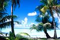
Mataiva, central lagoon

Mataiva, one of the uninhabited ring islands

Mataiva

Aerial view of Mataiva looking east
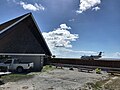
Air Tahiti arrives at Mataiva Airport


See also
Individual evidence
- ^ Dieter Mueller-Dombois & F. Raymond Fosberg: Vegetation of the Tropical Pacific Islands , Springer Verlag, New York-Berlin-Heidelberg 1998, ISBN 0-387-98313-9 , pp. 334–337
- ^ Christiane Dauphin: Prospection et inventaire archéologique de l'atoll de Mataiva. In: Dossier d'Archéologie Polynésienne, 2003-2004, Service de la culture et du patrimoine, Tahiti 2005
- ^ Christian Nau: Dictionnaire des Îles, Editions Mango, Paris 2002, ISBN 2-84270-358-8
- ^ Charles Darwin: The Structure and Distribution of Coral Reefs, Smith Elder and Co., London 1842
- ↑ Administration de la Polynésie française - Recensement de la population 2012
- ^ William C. Burnett and Stanley R. Riggs: Phosphate Deposits of the World: Genesis of Neogene to Recent, Cambridge University Press 1990, ISBN 9780521034180
literature
- B. Delesalle et al .: Environmental Survey of Mataiva Atoll, Tuamotu Archipelago French Polynesia. (PDF; 1.5 MB) Atoll Research Bulletin No. 286, May 1985.
Web links
- Mataiva on oceandots.com ( Memento from December 23, 2010 in the Internet Archive ) (English)
Ahe | Ahunui | Akiaki | Amanu | Anaa | Anuanuraro | Anuanurunga | Apataki | Aratika | Arutua | Faaite | Fakahina | Fakarava | Fangatau | Fangataufa | Hao | Haraiki | Héréhérétué | Hikueru | Hiti | Katiu | Kauehi | Kaukura | Makatea | Makemo | Manihi | Manuhangi | Maria Est | Morocco | Marutea North | Marutea Sud | Mataiva | Matureivavao | Morane | Motutunga | Mururoa | Napuka | Nengonengo | Niau | Nihiru | Nukutavake | Nukutepipi | Paraoa | Pinaki | Puka-puka | Puka Rua | Rangiroa | Raraka | Raroia | Ravahere | Reao | Reitoru | Rekareka | Taenga | Tahanea | Taiaro | Takapoto | Takaroa | Takume | Tatakoto | Tauere | Tekokota | Tematangi | Temoe | Tenararo | Tenarunga | Tepoto North | Tepoto Sud | Tikehau | Tikei | Toau | Tuanake | Tureia | Vahanga | Vahitahi | Vairaatea | Vanavana