Vairaatea
| Vairaatea | ||
|---|---|---|
| NASA image of Vairaatea | ||
| Waters | Pacific Ocean | |
| archipelago | Tuamotu Archipelago | |
| Geographical location | 19 ° 21 ′ S , 139 ° 13 ′ W | |
|
|
||
| Number of islands | 2 | |
| Main island | Puka Runga | |
| Land area | 3 km² | |
| Lagoon area | 13 km² | |
| Residents | 66 (2007) | |
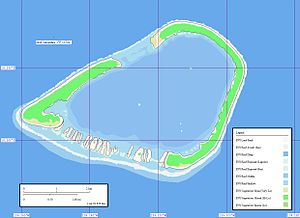
| Map of Vairaatea | ||
Vairaatea is an atoll in the Tuamotu Archipelago in the Pacific Ocean . Politically it belongs to French Polynesia and there to the municipality of Nukutavake . Vairaatea is around 38 kilometers away from the island of the same name, Nukutavake , and 180 kilometers from Hao Atoll .
The atoll consists of two larger, crescent-shaped islands in the northwest and in the east, numerous small motus and a shallow, central lagoon . Only the eastern island of Puka Runga is inhabited by 66 people who live in the main town of Ahura on the northern tip of the island. The main livelihoods of the population are fishing and the production of copra .
Vairaatea was possibly discovered for Europe as early as 1606 by the Portuguese navigator Pedro Fernández de Quirós . He named the island of San Miguel Archangel. The discovery by Samuel Wallis on June 6, 1767 is considered certain. He gave it the name "Egmont Island".
Remarks
- ↑ It may be the island of Anuanuraro
Web links
- Info about the atoll
- Census (PDF, French) ( Memento from February 29, 2008 in the Internet Archive )


