Amanu
| Amanu | ||
|---|---|---|
| NASA image by Amanu | ||
| Waters | Pacific Ocean | |
| archipelago | Tuamotu Archipelago | |
| Geographical location | 17 ° 48 ′ S , 140 ° 46 ′ W | |
|
|
||
| Number of islands | approx. 10 | |
| Main island | Ikitake | |
| Land area | 10 km² | |
| Lagoon area | 240 km² | |
| Residents | 163 (2007) | |
| Location of Amanu (8) | ||
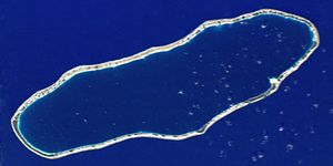
Amanu , formerly also called Freycinet or Moller , is an atoll in the southeast of the Tuamotu Archipelago , which belongs to French Polynesia .
The oval atoll, which consists of around ten motus , is located in the Pacific 900 kilometers east of Tahiti and 15 kilometers north of Hao Atoll , which is home to a port and an airport. Amanu is 29 kilometers long (northeast-southwest) and 10 kilometers wide. Administratively, the atoll belongs to the municipality of Hao .
Amanu was officially discovered in 1606 by the Spaniard Pedro Fernández de Quirós . It is possible that Francisco de Hoces landed here with the "San Lesmes" caravel as early as 1526. He was a member of the second Spanish Moluccas expedition under Fray Garcia Jofre de Loaisa, which was to follow Magellan's route. None of the seven ships returned. The "San Lesmes" was considered lost after leaving the Strait of Magellan.
In 1929 four old cast iron cannon barrels were found on one of the Amanu motus, some of which scientists assume that they belonged to the "San Lesmes", on which a German from Pomerania had also hired.
The climate on the Amanu Atoll is tropical; the largest island is inhabited by 163 (as of 2007) Polynesians who live mainly from fishing and from the coconut plantations on the neighboring small motus.
See also
Web links
- Picture and short description ( memento from December 23, 2010 in the Internet Archive )


