
Ahe (Tuamotu)
| Ah | ||
|---|---|---|
.jpg) |
||
| Waters | Pacific Ocean | |
| archipelago | Tuamotu Archipelago | |
| Geographical location | 14 ° 29 ′ S , 146 ° 19 ′ W | |
|
||
| Number of islands | - | |
| Main island | Teararoa | |
| Land area | 12 km² | |
| Lagoon area | 145 km² | |
| Residents | 561 (2007) | |
.jpg) |
||

Ahe (other names: Ahemaru, Omaru, Ahii ; old names: Viegen ( Jacob Le Maire ), Peacock Island ( Charles Wilkes )) is a shallow coral atoll in the northwest group of the Tuamotu Archipelago in the South Pacific . Geographically, Ahe belongs to the subgroup of the King George Islands ( Îles du Roi Georges ). The next inhabited island is Manihi , 14 km to the east.
geography
Ahe and the neighboring island of Manihi are located on the 2,760 m high "Ahe Seamount", which arose from a hot spot on the Pacific plate . The submarine mountain has sunk through tectonic processes and no longer protrudes above sea level. All that remains of the atoll is the dense, almost closed ring of numerous coral islets ( motus ), which together have a land area of almost 12 km². The 145 km² large, average 10 m deep and speckled with dangerous coral reef lagoon has only one passable passage to the Pacific Ocean (Passe de Tiareroa).
Politics and administration
Politically, the island belongs to the French Overseas Zealand ( Pays d'outre-mer - POM) French Polynesia and is therefore affiliated to the EU. It is administered by a subdivision ( Subdivision administrative des Îles Tuamotu-Gambier ) of the High Commission of French Polynesia ( Haut-commissariat de la République en Polynésie française ) based in Papeete . Together with neighboring Manihi, the island forms the political municipality of Manihi ( Commune de Manihi ) with a total of 1240 inhabitants, 555 of which are from Ahe itself. The official language is French. The currency is (still) the CFP franc, which is linked to the euro . The residents are predominantly of the Catholic denomination. The only place is Tenukupara on the island of Teararoa in the southwest with about 200 inhabitants. There are scattered settlements on a few other motus, which are densely overgrown with coconut palms and other tropical vegetation.
Infrastructure
In the north of the island, on an uninhabited motu, is the Ahe airfield ( ICAO-ID : NTHE), which opened in 1997 and is no more than a 1,240 m long asphalt runway that is only approached by small Air Tahiti aircraft.
There are no roads, just a dirt track that connects some of the Motus. The main means of transport is the boat.
The economic mainstay of the island today is the cultivation of black pearls . Several pearl farms are anchored in the lagoon. In addition, copra is exported to a small extent . Tourism hardly plays a role. There is only one privately operated guest house, no restaurants and no other tourist infrastructure. The small shop, which is only open from time to time, is supplied by the once a month ship from Tahiti and has only a limited supply.
history
Previously, a single reference to Polynesian natives is only known one adze from basalt by the American anthropologist Kenneth P. Emory during his South Sea Expedition from 1929 to 1934 for the Bishop Museum collected. There are no basalt deposits on Ahe. The archaeologist Marshall Weisler examined the material of the find and found that the rock was imported from Tahiti, 500 km away. Whether this find is evidence of a permanent settlement or just a temporary presence of early Polynesians has not yet been investigated in more detail.
The Dutch Willem Cornelisz Schouten and Jacob Le Maire were the first Europeans to reach the island of Ahe on April 19, 1616 with their ship Eendracht . Le Maire makes no statements about possible residents and calls the island "Viegen Eyland" because the crew was plagued by thick clouds of black flies.
“Shortly afterwards we found another island. There were many wild trees and a salt water lake inside. Our men were completely covered in flies when they came back on board, so that we could not examine any part of the island thoroughly. [...] We therefore called the island 'Fly Island' and left it in a westerly direction. "
On May 25, 1722 Jakob Roggeveen reached the island of Ahe with the ships Arend and Thienhoven , but did not go ashore. However, he gives an indication of possible residents: "[...] it is inhabited by savages, large in build and armed with bows and arrows."
The United States Exploring Expedition reached Ahe on September 4, 1839 and completed the first map of the island. Charles Wilkes named it "Peacock Island" after the USS Peacock , a sloop of the expedition. He himself went ashore with a group of scientists the following morning to take measurements and determine the exact position. Wilkes reports that the vegetation was similar to that of other flat Tuamotus islands, except that there were no coconut palms to be found. Ahe was uninhabited.
The French sailor, adventurer and publicist Bernard Moitessier lived for some time on the Motu Poro-Poro in a voluntarily chosen robinsonade in the late 1970s .
Picture gallery
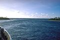
Entering the Passe de Tiareroa

Ahe lagoon
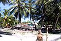
Tenukupara, Ahe Atoll


See also
Individual evidence
- ↑ SMNT-144S-1461W - Seamount Catalog
- ^ Institut Statistique de Polynésie Française (ISPF) - Recensement de la population 2012
- ↑ Stone Adze Compositions and the Extent of Ancient Polynesian Voyaging and Trade , Science, vol. 317 of September 29, 2007, pp. 1907-1911
- ↑ JAJ de Villiers: Being an Account of Joris Soeilbergen's Voyage Round the World (1614-1617), and the Australian navigations of Jacob Le Maire, The East and West Indian Mirror, Second Series, No. 18, London 1906
- ↑ Jacob Roggeveen: Twee Jahresige reyze rondom de wereld ter nader ontdekkinge der onbekende zuydlanden met drie scheper in het jaar 1721. ondernomen door last van de Nederlandsche Westindische Maatschappy […], Dortrecht 1728, p. 57
- ^ Charles Wilkes: Narrative of the United States Exploring Expedition during the years 1838, 1839, 1840, 1841, 1842, Philadelphia 1845, p. 350
Web links
- Image and short description (English) ( Memento of 27 January 2012 at the Internet Archive )
- Map with island names (French) ( Memento from April 1, 2017 in the Internet Archive ) (PDF)
- Map with island names
Ahe | Ahunui | Akiaki | Amanu | Anaa | Anuanuraro | Anuanurunga | Apataki | Aratika | Arutua | Faaite | Fakahina | Fakarava | Fangatau | Fangataufa | Hao | Haraiki | Héréhérétué | Hikueru | Hiti | Katiu | Kauehi | Kaukura | Makatea | Makemo | Manihi | Manuhangi | Maria Est | Morocco | Marutea North | Marutea Sud | Mataiva | Matureivavao | Morane | Motutunga | Mururoa | Napuka | Nengonengo | Niau | Nihiru | Nukutavake | Nukutepipi | Paraoa | Pinaki | Puka-puka | Puka Rua | Rangiroa | Raraka | Raroia | Ravahere | Reao | Reitoru | Rekareka | Taenga | Tahanea | Taiaro | Takapoto | Takaroa | Takume | Tatakoto | Tauere | Tekokota | Tematangi | Temoe | Tenararo | Tenarunga | Tepoto North | Tepoto Sud | Tikehau | Tikei | Toau | Tuanake | Tureia | Vahanga | Vahitahi | Vairaatea | Vanavana