Taiaro
| Taiaro | ||
|---|---|---|
| LANDSAT image by Taiaro | ||
| Waters | Pacific Ocean | |
| archipelago | Tuamotu Archipelago | |
| Geographical location | 15 ° 43 ′ S , 144 ° 37 ′ W | |
|
|
||
| Number of islands | 1 | |
| Main island | Taiaro | |
| Land area | 6 km² | |
| Lagoon area | 12 km² | |
| Residents | 4 (2012) | |
| Map of Taiaro | ||
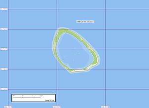
Taiaro also Maro-taua is an atoll in the Tuamotu Archipelago in French Polynesia . Administratively, the atoll belongs to the municipality of Fakarava . Taiaro has the shape of a polygon with a diameter of about 3.7 km. The atoll's deep, sandy lagoon has no navigable access to the sea. As of the 2012 census, the atoll had four inhabitants.
history
The atoll was discovered by Robert FitzRoy in 1835 . It was also the last of the Tuamotu archipelago to be discovered.
On September 3, 1839, the atoll was approached by a research expedition led by Charles Wilkes . Wilkes named the island Kings Island, inspired by the first name of the lookout who first sighted the atoll.
In 1977, Taiaro was placed under UNESCO control as a biosphere reserve in order to protect the biodiversity of Polynesia .
The atoll is privately owned by W. A. Robinson. There is no infrastructure on the island.
Web links
- Picture and short description ( memento from December 23, 2010 in the Internet Archive )
- Information Biosphere Reserve (English)
- Expedition 1994 report (English)
- JL Young: Names Of The Paumotu Islands, with the old names so far as they are known. December 1899, pp. 264–268 , accessed January 30, 2019 (English).
- Charles Wilkes (English) and United States Exploring Expedition (English)
Individual evidence
- ↑ Archived copy ( memento of the original from October 24, 2014 in the Internet Archive ) Info: The archive link was inserted automatically and has not yet been checked. Please check the original and archive link according to the instructions and then remove this notice.


