Napuka
| Napuka | ||
|---|---|---|
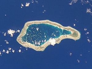
| NASA image of Napuka | ||
| Waters | Pacific Ocean | |
| archipelago | Tuamotu Archipelago | |
| Geographical location | 14 ° 12 ′ S , 141 ° 15 ′ W | |
|
|
||
| Number of islands | 30th | |
| Land area | 8 km² | |
| Lagoon area | 18 km² | |
| Residents | 271 (2007) | |
| Location of Napuka (1) | ||
Napuka is an atoll in the Tuamotu Archipelago in French Polynesia . The atoll belongs to the Îles du Désappointement , administratively to the municipality of Napuka . The closest atoll is Tepoto North , 15 km southeast. Napuka is 10.5 km long and 4 km wide. The atoll's lagoon covers about 18 square kilometers and has no navigable access to the sea. It becomes flatter to the east.
Napuka is also called "Islands of Disappointment", Pukaroa or (outdated: Wytoohee).
history
The atoll was probably discovered at the end of January 1521 by Ferdinand Magellan , who could not find any water on the atoll or on the neighboring atoll Tepoto Nord for his onward journey. So the two arid islands got their European name Islands of Disappointment .
In the middle of the 19th century, the atoll was visited and mapped by the United States Exploring Expedition under Charles Wilkes . Wilkes named the island Wytoohee Island .
In 1977 an airfield was completed on the atoll. The most important place on the island, which is almost exclusively inhabited by Polynesians , is Tepukamaruia or Te Puka Maru Ia .
Web links
- Brief description and picture of the atoll ( memento from December 23, 2010 in the Internet Archive )
- Census 2007 ( Memento of February 29, 2008 in the Internet Archive ) (PDF, French)
- Napuka Airport ( Memento of December 2, 2008 in the Internet Archive ) (English)
- JL Young: Names Of The Paumotu Islands, with the old names so far as they are known. December 1899, pp. 264–268 , accessed January 30, 2019 (English).
- American Research Expedition (English)
- Charles Wilkes (English)


