Arutua
| Arutua | ||
|---|---|---|
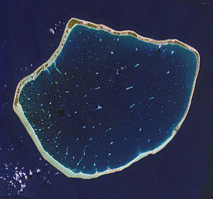
| NASA image of Arutua | ||
| Waters | Pacific Ocean | |
| archipelago | Tuamotu Archipelago | |
| Geographical location | 15 ° 19 ′ S , 146 ° 43 ′ W | |
|
|
||
| Number of islands | 51 | |
| Main island | Rautini | |
| Land area | 14 km² | |
| Lagoon area | 484 km² | |
| Residents | 725 (2007) | |
| Map of Arutua | ||
Arutua is an atoll in the municipality of the same name Arutua in French Polynesia . Arutua is one of the Îles Palliser , a subgroup of the Tuamotu Archipelago . Arutua means "wave of the high seas".
The atoll is located 406 km northwest of Tahiti , 40 km southwest of Rangiroa and 16 km east of Apataki Atoll , the closest island. The shape of the 31 km long and 24 km wide Arutua Atoll is reminiscent of a pentagon, the enclosed lagoon is wide, deep and has a navigable passage and a small island in its center. The lagoon covers an area of 484 km², the land area of the atoll only 15 km².
According to the 2007 census, 725 people live on Arutua, the most important settlement is called Rautini . It was completely rebuilt after cyclones in 1983. Copra and mother-of-pearl are produced on the island . There are rich fishing grounds in the lagoon.
history
The first European who has demonstrably reached the Arutua Atoll was Jakob Roggeveen , the discoverer of Easter Island , in 1722. In 1816 Otto von Kotzebue reached the island. The name of his ship Rurik was subsequently used for the atoll.
In 1826 the Briton Frederick William Beechey came to Arutua and named the atoll "Cockburn Island".
After the main village of Rautini, which had been destroyed by cyclones, was rebuilt, Arutua received a runway in 1984.
The residents live from copra production , tourism and the sale of mother- of- pearl .
See also
Web links
- Picture and short description ( memento from December 23, 2010 in the Internet Archive )
- Census 2007 ( Memento from April 9, 2008 in the Internet Archive ) (PDF; French; 22 kB)
- Tourism information (French)
- Map of Arutua


