Ravahere
| Ravahere | ||
|---|---|---|
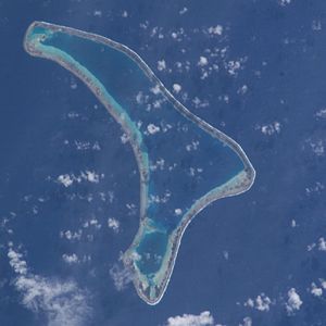
| NASA image of Ravahere | ||
| Waters | Pacific Ocean | |
| archipelago | Tuamotu Archipelago | |
| Geographical location | 18 ° 13 ′ S , 142 ° 9 ′ W | |
|
|
||
| Number of islands | - | |
| Land area | 70 ha | |
| Lagoon area | 5.1 km² | |
| Residents | uninhabited | |
Ravahere (old name: Dawhaida or Dawhaida Island ) is an uninhabited atoll in the Tuamotu Archipelago in French Polynesia . It is located 53 km northwest of Nengonengo and is only separated from Morocco by a 2 km wide waterway . The boomerang-like island has a length of 18 km with a maximum width of 7.5 km. The atoll's lagoon has no navigable access to the sea.
Ravahere and Morocau form the so-called Îles Deux Groupes . Ravahere is part of the Hikueru Township .
It is probably identical with the island of Morocco (also Marakau), discovered on March 24, 1768 by Louis Antoine de Bougainville .
Individual evidence
- ^ Andrew Sharp: The Discovery of the Pacific Islands. Oxford University Press 1960, p. 115
Web links
- Picture and short description ( memento from December 23, 2010 in the Internet Archive )
- Travel Impressions of the atoll and coral reefs (English)

