
Tikehau
| Tikehau | ||
|---|---|---|
.jpg) |
||
| Waters | Pacific Ocean | |
| archipelago | Tuamotu Archipelago | |
| Geographical location | 14 ° 59 ′ S , 148 ° 10 ′ W | |
|
||
| Number of islands | - | |
| Main island | Tuherahera | |
| length | 26 km | |
| width | 23 km | |
| Land area | 2.5 km² | |
| Lagoon area | 461 km² | |
| Residents | 507 (2007) | |
 |
||

Tikehau is an atoll in the Tuamotu Archipelago in the Pacific Ocean . It is a " Commune associée " (sub-municipality) of the municipality of Rangiroa and politically belongs to French Polynesia .
Tikehau is located about 320 km north of Tahiti in the northwest of the archipelago. It has an area of about 26 by 23 km. The lagoon measures 461 km². Smaller supply ships can get to the port within the lagoon through the 150 m wide and maximum 4 m deep Passe Tuheiava on the west side .
The atoll was discovered for Europe on April 25, 1816 by Otto von Kotzebue as part of a Russian expedition. The atoll was named "Kruzenstern" after the German-Baltic Admiral Adam Johann von Krusenstern . This name is still quite familiar to today's residents.
The main island and town are called Tuherahera , located on the southern tip of the atoll. In 2007 about 507 people lived on Tikehau. The main sources of income are the state-subsidized production of copra , commercial fishing and a little tourism. There is a bakery, two small shops and a tiny snack bar. In 2001 a tiny sawmill was built with government support, in which around three to five locals find work. The breeding of black pearls, which began with a lot of enthusiasm in the 1990s, has come to a standstill. There is also a diving center , a luxury hotel and an airport with the IATA airport code TIH.
Picture gallery

A row of small motu on the Tikehau atoll. In the background the inner lagoon
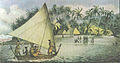
Tikehau in 1816 (drawn by Ludwig Choris )


See also
Web links
- Article with a map of the atoll (page 17)
Individual evidence
- ^ Hilary Rogers, Jean-Bernard Carillet, Tony Wheeler: Tahiti & French Polynesia. Lonely Planet Publications , 188
- ^ Institut Statistique de Polynésie Française (ISPF) - Recensement de la population 2007 ( Memento of February 29, 2008 in the Internet Archive ) (PDF, French)
Ahe | Ahunui | Akiaki | Amanu | Anaa | Anuanuraro | Anuanurunga | Apataki | Aratika | Arutua | Faaite | Fakahina | Fakarava | Fangatau | Fangataufa | Hao | Haraiki | Héréhérétué | Hikueru | Hiti | Katiu | Kauehi | Kaukura | Makatea | Makemo | Manihi | Manuhangi | Maria Est | Morocco | Marutea North | Marutea Sud | Mataiva | Matureivavao | Morane | Motutunga | Mururoa | Napuka | Nengonengo | Niau | Nihiru | Nukutavake | Nukutepipi | Paraoa | Pinaki | Puka-puka | Puka Rua | Rangiroa | Raraka | Raroia | Ravahere | Reao | Reitoru | Rekareka | Taenga | Tahanea | Taiaro | Takapoto | Takaroa | Takume | Tatakoto | Tauere | Tekokota | Tematangi | Temoe | Tenararo | Tenarunga | Tepoto North | Tepoto Sud | Tikehau | Tikei | Toau | Tuanake | Tureia | Vahanga | Vahitahi | Vairaatea | Vanavana