
Puka Rua
| Puka Rua | ||
|---|---|---|
 |
||
| Waters | Pacific Ocean | |
| archipelago | Tuamotu Archipelago | |
| Geographical location | 18 ° 19 ′ S , 137 ° 1 ′ W | |
|
||
| Number of islands | - | |
| Main island | Puka Rua | |
| Land area | 7 km² | |
| Lagoon area | 23 km² | |
| Residents | 207 (2007) | |
 |
||

Puka Rua (other spelling: Pukaruha , old name: Serle or Serle Island ) is an atoll in the far east of the Tuamotu Archipelago in the South Pacific .
geography
Puka Rua consists of an elongated main island with 64 small and smallest motus . The atoll is a total of 15 km long and 3.5 km wide. The main island, somewhat reminiscent of a fish hook, stretches the entire length on the east side and is only 300 m wide. The total land area of all islands is 6.5 km², but the lagoon is much larger at 23 km².
The former volcanic central island of the atoll has sunk a long time, which speaks for a geologically quite old age. The atoll is surrounded by a coral reef , with only one artificially deepened, narrow passage at the level of the village.
Only small remnants of the original flora have survived on some smaller motus. The vegetation on the main island was extensively redesigned in the 19th and 20th centuries for the creation of coconut plantations.
Administration and Infrastructure
Politically, Puka Rua is a sub-municipality ( Commune associée ) of the municipality of Reao and belongs to French Polynesia . The only village, Marautagaroa in the north of the main island, has 207 inhabitants. At the edge of the village there is another shelter of the Center d'expérimentation du Pacifique (CEP) , in which the residents were supposed to take shelter during the French nuclear tests on Mururoa and Fangataufa .
In 2000, an airstrip with a 1,000 m long runway was opened and in April 2006 it was extended to 1,200 meters. The regional airport is only served by small Air Tahiti propeller planes . A mainly unpaved road crosses the main island from north to south and opens up the airfield and the coconut plantations.
The island exports a small amount of copra , which is dried and stored in two open warehouses. It is shipped from a pier that only allows small boats to enter.
The relatively shallow lagoon is interesting for divers and snorkelers because of the numerous giant or killer clams ( Tridacna gigas ) (Polynesian: paʻua), sea cucumbers and pink oysters . However, there is no tourist infrastructure at all.
history
Systematic archaeological excavations have not yet taken place on Puka Rua. In 1930, the American anthropologist Kenneth P. Emory of the Bernice P. Bishop Museum in Honolulu searched the surface for the remains of indigenous structures. In the southeastern part of the island he found the remains of a ceremonial platform, the Marae Heragi, whose main axis is still preserved today and is built parallel to the lagoon. To the east of this installation, Emory saw the remains of another small platform, about 3 m long and 1.5 m wide, of which only a pile of stones remains today. There is also said to have been a natives marae behind the church , but it is completely destroyed today.
At the southern end of the atoll, near Maite, the traces of planting pits of the Polynesian natives can still be seen in a coconut grove. The Ghyben-Herzberg lentil was cut with long trenches and the depression was then filled with humus and compost in order to enable the cultivation of taro , a plant that prefers swampy terrain, on the poorly watery and poorly fertile sandy soils .
There is a high probability that Puka Rua is identical to the island discovered on June 28, 1797 by James Wilson, captain of the British mission ship Duff :
“On the 28th, we discovered again one of the low islands on which coconut palms grew, which made us eager to land on it to get some of these refreshing fruits for the crew and fresh grass for our goats. We succeeded in landing, albeit with great difficulty because of the strong surf that is incessantly found on the coral rocks. Far greater, however, were the difficulties in getting back to the boats from the island, and only after we had spent a sad night there in heavy rainy weather, were we so happy to get back to our boats with mortal danger and great discomfort, whereupon we made a vow never to venture onto one of these half-flooded islands without extreme necessity. The island became Serlesinsel [in Engl. Original text: serle's island ]. "
Wilson named the island after Ambrose Serle (1742-1812), the secretary of Lord Howe and author of the book "Horae Solitariae", a pious treatise that was very popular at the time.
The Wilson report gives no indication of possible residents. A first reference to the Polynesian inhabitants is Frederick William Beechey , who visited Puka Rua on January 21, 1826, but did not go ashore. As the Blossom circumnavigated the north-western tip a short distance away, Beechey could see several tattooed warriors armed with spears or long sticks and clubs, as well as several scantily clad women. Some columns of smoke rose behind the trees, suggesting a settlement. Beechey estimates the population at a maximum of one hundred people, he could not make out boats or canoes.
The first detailed map was drawn during the United States Exploring Expedition (US Ex. Ex.), Which explored the Pacific and Antarctic regions by the United States Navy from 1838 to 1842 under the command of Charles Wilkes . The researchers of the US Ex. Ex. Landed on Puka Rua on August 16, 1839 under the command of Lieutenant Alden and explored the island for a day. Alden reports of only a few residents who met the visitors in a peaceful and curious manner. Some of the men were tattooed and armed with spears.
- Views
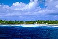
Puka Rua, main island with the village of Marautagaroa

Marautagaroa Church
Puka Rua

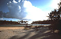
Palm grove on Puka Rua, in the background the lagoon


See also
Individual evidence
- ↑ as of 2007; http://www.polynesie-francaise.pref.gouv.fr/sections/les_communes/presentation/tg/ ( page no longer available , search in web archives ) Info: The link was automatically marked as defective. Please check the link according to the instructions and then remove this notice.
- ↑ Kenneth P. Emory: Tuamotuan Stone Structures. Honolulu 1934, p. 76.
- ^ Edward H. Tatum, Jr.: The American Journal of Ambrose Serle, Secretary to Lord Howe, 1776–1778, New York 1969
- ^ Frederick William Beechey: Narrative of a Voyage to the Pacific and Beering's Strait, to Co-operate With the Polar Expeditions Performed in His Majesty's Ship Blossom Under the Command of Captain FW Beechey RN in the Years 1825, 1826, 1827, 1828. London 1831, p. 135.
- ^ Charles Wilkes: Narrative of the United States Exploring Expedition During the Years 1838, 1839, 1840, 1841, 1842 by Charles Wilkes, USN, Philadelphia 1845, Volume 1, pp. 327-328.
Ahe | Ahunui | Akiaki | Amanu | Anaa | Anuanuraro | Anuanurunga | Apataki | Aratika | Arutua | Faaite | Fakahina | Fakarava | Fangatau | Fangataufa | Hao | Haraiki | Héréhérétué | Hikueru | Hiti | Katiu | Kauehi | Kaukura | Makatea | Makemo | Manihi | Manuhangi | Maria Est | Morocco | Marutea North | Marutea Sud | Mataiva | Matureivavao | Morane | Motutunga | Mururoa | Napuka | Nengonengo | Niau | Nihiru | Nukutavake | Nukutepipi | Paraoa | Pinaki | Puka-puka | Puka Rua | Rangiroa | Raraka | Raroia | Ravahere | Reao | Reitoru | Rekareka | Taenga | Tahanea | Taiaro | Takapoto | Takaroa | Takume | Tatakoto | Tauere | Tekokota | Tematangi | Temoe | Tenararo | Tenarunga | Tepoto North | Tepoto Sud | Tikehau | Tikei | Toau | Tuanake | Tureia | Vahanga | Vahitahi | Vairaatea | Vanavana