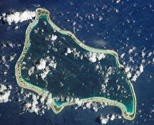
Marutea Sud
| Marutea Sud | ||
|---|---|---|
| NASA image of Marutea Sud | ||
| Waters | Pacific Ocean | |
| archipelago | Tuamotu Archipelago | |
| Geographical location | 21 ° 30 ′ S , 136 ° 28 ′ W | |
|
|
||
| Number of islands | - | |
| Main island | - | |
| Land area | 14 km² | |
| Lagoon area | 112 km² | |
| Residents | 178 (2002) | |
| Location of Marutea Sud (2) | ||
Marutea Sud is an atoll in the Tuamotu Archipelago in French Polynesia . The next atoll, Maria Est, is 72 km northeast. The atoll, completely surrounded by a coral reef, is 21 km long by 10 km wide.
Marutea Sud should not be confused with the atoll Marutea Nord in the western part of the Tuamotu Archipelago. Administratively, Maruta Sud belongs to the municipality of Gambier .
history
The atoll was discovered by the Spanish navigator Pedro Fernández de Quirós on February 4, 1606. He called the island "San Telmo". Other well-known Spanish names are San Blas and Corral de Agua. Even Edward Edwards drove this Atoll in 1791, the mutineers of the HMS Bounty to find. Edwards named the atoll Lord Hood.
When the Russian admiral Adam Johann von Krusenstern visited the atoll in 1825, it was still exclusively inhabited by Polynesian natives.
In 1984 the atoll was bought by the pearl dealer Robert Wan in order to build mussel beds on its beaches for pearl cultivation. Black Tahitian pearls ( Pinctada margaritifera cumingi ) in particular are said to be grown here.
In 1993 a private airfield was created by Wan.
The most important place on the island is Auorotini, but this is only temporarily inhabited in order to harvest pearls and to control the mussel beds.
Web links
- Picture and short description ( memento from December 23, 2010 in the Internet Archive )
- JL Young: Names Of The Paumotu Islands, with the old names so far as they are known. December 1899, pp. 264–268 , accessed January 30, 2019 (English).
- Tahitian black pearls (English)


