Ferry from the municipality of Gambier.
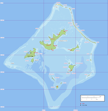
Map of the Gambier Islands.
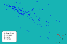
Location of the Tuamotu atolls in the Gambier municipality.
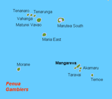
Islands and atolls of the municipality of Gambier.
Gambier is a municipality at the southeast end of the Tuamotu Archipelago in French Polynesia .
The community consists of the Gambier Islands (five islands and several uninhabited islets in a large lagoon and a separate atoll), seven atolls of the Tuamotus and three submarine reefs south and east of the Gambier Islands. The main town of the municipality is Mangareva. The municipality's INSEE code is 98719. The zip code is 98755.
Atoll
main place
Inhabitants
Land area
Lagoon
Coordinates
Gambier Islands
Mangareva Rikitea 870
15.4
-
! 476.8937425365.0281535 23 ° 06 ′ S , 134 ° 58 ′ W -23.106258333333 -134.97184722222
Aukena Purirau
31
1.35
-
! 476.8688895365.0980565 23 ° 08 ′ S , 134 ° 54 ′ W -23.131111111111 -134.90194444444
Akamaru Tokani
11
2.1
-
! 476.8161115365.0863895 23 ° 11 ′ S , 134 ° 55 ′ W -23.183888888889 -134.91361111111
Kamaka
4th
0.5
-
! 476.7566675365.0422225 23 ° 15 ′ S , 134 ° 57 ′ W -23.243333333333 -134.95777777778
Taravai Agakono
3
5.7
-
! 476.8500005364.9666675 23 ° 09 ′ S , 135 ° 02 ′ W -23.15 -135.03333333333
Isles
-
0
6th
419
! 476.8666675365.0500005 23 ° 08 ′ S , 134 ° 57 ′ W -23.133333333333 -134.95
Temoe -
0
2.1
12
! 476.6500005365.5166675 23 ° 21 ′ S , 134 ° 29 ′ W -23.35 -134.48333333333
Tuamotu atolls in the Gambier municipality
Matureivavao -
0
2.5
18th
! 478.5333335363.6000005 21 ° 28 ′ S , 136 ° 24 ′ W -21.466666666667 -136.4
Tenararo -
0
2
1.6
! 478.7000005363.2500005 21 ° 18 ′ S , 136 ° 45 ′ W -21.3 -136.75
Tenarunga -
0
2.2
5
! 478.6500005363.4666675 21 ° 21 ′ S , 136 ° 32 ′ W -21.35 -136.53333333333
Vahanga -
0
2
5
! 478.6666675363.3500005 21 ° 20 ′ S , 136 ° 39 ′ W -21.333333333333 -136.65
Moraine -
0
2
11
! 476.8500005362.8666675 23 ° 09 ′ S , 137 ° 08 ′ W -23.15 -137.13333333333
Marutea Sud Auorotini
178
14th
112
! 478.4833335364.4500005 21 ° 31 ′ S , 135 ° 33 ′ W. -21.516666666667 -135.55
Maria Est -
0
3
7th
! 477.9833335363.8166675 22 ° 01 ′ S , 136 ° 11 ′ W -22.016666666667 -136.18333333333
Submarine reefs
Portland Bank -
0
0
8th
! 476.3333335365.6666675 23 ° 40 ′ S , 134 ° 20 ′ W -23.666666666667 -134.33333333333
Minerve Reef
-
0
0
240
! 477.3333335366.5000005 22 ° 40 ′ S , 133 ° 30 ′ W -22.666666666667 -133.5
Bertero reef -
0
0
! 477.9333335366.3833335 22 ° 04 ′ S , 133 ° 37 ′ W. -22.066666666667 -133.61666666667
Rikitea 1097
61
591
The four atolls Matureivavao, Tenararo, Tenarunga and Vahanga form the group of the Actéon Islands .
Footnotes
↑ a b historical village; current settlement not in the same place
^ Motus of the atoll ring and islet in the lagoon
↑ Area of the lagoon in which the Gambier Islands are located
↑ a b The lagoon areas of the submarine reefs are not included in the total
↑ The Bertero reef reported in 1829 was not found in a search in 2000. Its existence is therefore in doubt http://permanent.access.gpo.gov/websites/pollux/pollux.nss.nima.mil/NAV_PUBS/SD/pub126/126sec01.pdf . According to another source, Bertero is another name for the Minerva Reef http://www.sil.si.edu/digitalcollections/atollresearchbulletin/issues/00018.pdf
-23.15 -134.95 Coordinates: 23 ° 9 ′ S , 134 ° 57 ′ W
<img src="https://de.wikipedia.org//de.wikipedia.org/wiki/Special:CentralAutoLogin/start?type=1x1" alt="" title="" width="1" height="1" style="border: none; position: absolute;">


