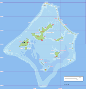
Taravai
| Taravai | ||
|---|---|---|
| Waters | Pacific Ocean | |
| Archipelago | Gambier Islands | |
| Geographical location | 23 ° 8 '55 " S , 135 ° 2' 10" W | |
|
|
||
| length | 4.8 km | |
| width | 2.4 km | |
| surface | 5.7 km² | |
| Highest elevation | 256 m | |
| Residents | 9 (2012) 1.6 inhabitants / km² |
|
| main place | Agakono (historical) | |
Taravai is the second largest of the Gambier Islands in French Polynesia .
geography
It is located two kilometers southwest of Mangareva .
Taravai is 5.7 km², the highest point on the island is 256 m above sea level. The island has nine inhabitants (2012), the only village is Agakono , located on a bay in the east.
history
The island was discovered by James Wilson in 1797 . The relatively large Saint Gabriel Church , built in 1868, is a remnant of the Catholic missionary work in the Gambier Islands in the first half of the 19th century by the French order “Pères et religieuses des Sacrés-Cœurs de Picpus” (or “Picpusiens”, named after the order's seat on Picpus Street in Paris ). 2,000 people once lived on the now almost deserted island.
The lush vegetation is limited to the narrow coastal strip. With increasing height, the vegetation becomes sparser, the mountain peaks of the strongly profiled island are arid .

