
Mangareva
| Mangareva | ||
|---|---|---|
 |
||
| Waters | Pacific Ocean | |
| Archipelago | Gambier Islands | |
| Geographical location | 23 ° 6 '34 " S , 134 ° 57' 57" W | |
|
||
| length | 8 kilometers | |
| width | 1.3 km | |
| surface | 18 km² | |
| Highest elevation |
Mont Duff 441 m |
|
| Residents | 1384 (2017) 77 inhabitants / km² |
|
| main place | Rikitea | |
 |
||

Mangareva (old name: Peard or Peard's Iceland ) is the largest island of the archipelago of the Gambier Islands in the eastern South Pacific , is politically to French Polynesia . The Polynesian term “Mangareva” roughly translates as: The mountain floating on the water.
geography
Although the landscape is completely different, Mangareva is geographically part of the Tuamotu Archipelago . The 8 km long and at its narrowest point 1.3 km wide island lies - together with the other Gambier Islands - within a large lagoon more than 25 km in diameter . The hilly, steeply rising island from the sea has a not very extensive coastal plain in which the settlements are located. The interior of the island is largely undeveloped and uninhabited. The highest peaks are the Mont Duff with 441 m and the Mont Mokoto with 423 m in the south. The south-east side is formed by a large crescent-shaped bay on which the main town of Rikitea is located, on the north-west side there are three further bays separated by peninsulas, where smaller settlements are located.
geology
The Gambier Archipelago emerged from a hot spot that moves with the Pacific Plate at a speed of 12.5 cm per year in a north-westerly direction. Mangareva is part of the so-called Pitcairn-Mangareva linear chain , a chain of islands of volcanic origin, the age of which decreases from northwest to southeast. Located in the northwest of the chain, Mangareva is part of an atoll that was formed 5.6 to 5.7 million years ago. The volcanic central island of this atoll has largely sunk. Managreva is only a remnant of the heavily eroded crater rim , which consists mainly of igneous rocks . The caldera of the long-sunken volcano can still be guessed at from the location of Mangareva and the neighboring islands in the lagoon .
flora
The coastal plains are lush, but mostly with anthropochoric plants. The middle and higher areas of the island, however, are covered with thick bush or sparse grass vegetation, the heights of Mt. Duff and Mt. Mokoto (425 m) are arid . The endemic species Lipocarpha mangarevica and Achyranthes mangarevica have been extinct since the early 1930s, presumably due to fires and goats.
The biologist Jared Diamond believes that the island's extensive deforestation was the result of massive interference by the Polynesian natives. However, this theory has not yet been adequately supported by archaeobotanical studies. One compared to other Polynesian islands, e.g. B. the Marquesas, relative poverty of the vegetation can also be observed on other Gambier Islands, which were not inhabited in protohistoric times. It cannot be ruled out that climatic and other natural conditions are responsible for this. There is no doubt that the Polynesian natives have significantly transformed their environment, especially in the populated coastal strip. In the area of natural water sources, large terraced and artificially irrigated fields for wet field cultivation of taro (similar to wet rice cultivation ) have been demonstrated. However, it has not yet been proven whether these interventions also resulted in deforestation in the higher island areas. A not inconsiderable part of the forest destruction is likely to be ascribed to the construction projects of the missionaries. If contemporary reports are to be believed, numerous large trees were felled for the burning of lime.
history
see also → History of the Gambier Islands
prehistory
Since the culture of the Gambier Islands did not produce any script, the prehistory is difficult to reconstruct - solely based on oral traditions and archaeological findings.
The mythical ancestor of all the inhabitants of Mangareva was Tupa, who is said to have settled the island from "Ruapou" ( Ua Pou ?). According to legend, he brought breadfruit, coconut and other food crops to Mangareva, but later returned to his home island. His son Anua-motua followed with his extended family, settled the island and became the first king of the archipelago. He divided the islands of the archipelago among his sons who formed the ancestors of the various tribes.
Parallels in the language of Mangareva with that of the Marquesas Islands suggest that Mangareva was settled from the Marquesas, possibly with a stopover on the eastern Tuamotus . Recent publications suggest settlement of the Society Islands is more likely. When this settlement took place as part of the Polynesian expansion has not been conclusively clarified. Older views assume no settlement before the 13th century. More recent radiocarbon dates provide dates that date back to the early 12th century. The Polynesians probably settled there as early as 1000 AD, possibly even two hundred years earlier.
The archaeologist Marshall Weisler of the University of Otago has demonstrated flourishing trade relations between Mangareva, Pitcairn and Henderson in protohistorical times . Mangareva exported oyster shells for jewelry and tools, as well as basalt oven stones and imported turtles and ornamental feathers from Henderson and obsidian tools from Pitcairn. For several centuries Mangareva played a key role in maritime trade, which was essential for maintaining the settlement of the southeastern and resource-poor Pitcairn Islands . There were apparently trade relations with the Marquesas Islands, 1,500 km away. During excavations on Mangareva, stone tools made from the basalt of the Marquesas came to light.
Mangareva's form of society was a strictly stratified tribal society, which was divided into a hereditary nobility , the sole landowners ( togo'iti ), the priests ( taura ) and the common, working people ( 'urumanu ). Later, probably from the 14th century, a middle class of warriors ( pakacra ) was able to establish itself. There were several clans who were fighting each other in constant, ritualized wars. Human sacrifice and cannibalism were not unknown.
There is evidence that before European influence began, a radical change was underway that led to turmoil and civil war between the social classes. According to tradition, the subjects rose against their king Te Mangi-tu-tavake by refusing to pay tribute . A new king, Teiti-a-touou, was established, a popular warlord who could not trace his descent to his mythical ancestors. The upheavals probably led to a destabilization of society, which resulted in the abandonment of trade around 1450. In contrast, the evolutionary biologist Jared Diamond suspects in his book Collapse a man-made ecological catastrophe on Mangareva as the cause.
The archaeological relics of Mangareva's native Polynesians are sparse. Some stone house platforms have been preserved, the ceremonial platforms were completely destroyed and the stones used in the missionaries' buildings. The locations of the two largest and most important marae on the island are known (in Rikitea, not far from the church), but there are no recognizable remains of them.
European discovery

The London Missionary Society , founded in 1795, equipped the ship Duff under the command of James Wilson to bring missionaries to Tahiti , Tonga and the Marquesas. On the drive from Tongatapu to the Marquesas, Wilson chose a southerly course to get into westerly winds. On May 24, 1797, it passed Mangareva, but did not land. He named the highest mountain on the island "Mount Duff" after his ship.
Frederick William Beechey anchored with the HMS Blossom on December 29, 1825 at Mangareva. He named the island "Peard's Island" after his First Lieutenant George Peard. He named the surrounding islands of the Gambier Archipelago Belcher, Wainwright, Elson, Collie and Marsh after other officers of his ship.
The growing influence of Europe, especially France , on the Society Islands was not without consequences for Mangareva. The Pomaré dynasty of Tahiti, supported by the Europeans, extended their influence to other Polynesian islands. King Pomaré II also established himself as ruler of the Gambier archipelago at the beginning of the 19th century. In 1881 France took over Mangareva's administration.
Mission history

In 1834, the Fathers Honoré Laval and François d'Assise Caret of the order "Pères et religieuses des Sacrés-Cœurs de Picpus" (Picpusiens for short, in Germany Arnstein Fathers ) arrived on the ship Peruviana on the small neighboring island of Akamaru . On the very day of arrival, Pére Laval began his missionary work by overthrowing the wooden idols from the marae . At first, King Maputeoa, the last king of Mangareva, offered tentative resistance, but after he attributed the recovery from a serious illness to the new god, he came more and more under the influence of the Christian missionaries and was baptized in 1836. First with toleration and later with the active support of the king, the Picpusiens began a comprehensive development program for the islands. This included extensive construction work, the introduction of cotton cultivation, pearl and mother-of-pearl fishing, and the creation of plantations and kitchen gardens. All these measures were forcibly implemented, whereby the hierarchically structured tribal society of Mangareva with the characteristics of a medieval European feudal society was extremely helpful.
In place of the pagan cult platforms, churches, a nunnery, a boarding school for girls, schools, a hospital, workshops, two prisons, a royal palace and an elaborately built rectory were built. For this purpose, the Picpusiens workers from the surrounding islands were forced to go to Mangareva. Those who did not work on the numerous construction projects were assigned to pearl fishing in the lagoon. The pearls coveted in Europe and even more the mother-of-pearl brought the order considerable wealth, which could be used to finance the buildings.
The most impressive and intact structure of the order is the church of Saint Michel in Rikitea, called "South Sea Cathedral", which was built in the record time of 20 months. With its two towers , the whitewashed cathedral, somewhat reminiscent of Notre-Dame de Paris , can accommodate 1,500 people. That is far more than the island's population. The three-aisled basilica is 62 meters long, 21 meters wide and 32 meters high. Inside, 20 round, eight meter high columns support the roof. The altar is backed with numerous shiny black and selected beautiful mother-of-pearl bowls. Allegedly there was a fabulously large black pearl on the altar, which is said to be under lock and key in the Vatican today .
The forced employment of workers for the major projects depopulated the smaller Gambier Islands and led to famine, as the daily food procurement was neglected. This and the spread of previously unknown infectious diseases resulted in a drastic population decline and impoverishment. To what extent this is the responsibility of the missionaries is hotly debated. What is certain is that the mission suppressed constant tribal wars in the long term and eliminated human sacrifice and cannibalism.
The French governor of Tahiti watched the goings-on in Laval for many years. It was only when complaints from European businessmen and merchant ships were mounting that he intervened. Père Laval had to leave Mangareva in 1871 at the behest of the Bishop of Tahiti, Florentin Etienne "Tepano" Jaussen. He died poor and bitter on November 1st, 1880 and was buried in Tahiti.
Nuclear weapons tests
The nuclear weapons tests carried out by the French military from 1966 to 1995 on the Mururoa Atoll, about 400 km away, led to a temporary economic boom on Mangareva. To reduce the dangers of radioactive precipitation , a large shelter in Rikitea and an observation bunker for the military personnel in the northeast of the island were built for the population. Remnants of the systems are still there. The shelter now serves as a warehouse.
Politics and administration
Mangareva is now a part of the municipality ( Commune associée ) of the municipality of Gambier ( Commune des Gambier ). It is administered by a subdivision ( Subdivision administrative des Îles Tuamotu-Gambier ) of the High Commission of French Polynesia ( Haut-commissariat de la République en Polynésie française ) based in Papeete .
According to the 2012 census, the municipality of Gambier has a total of 1,445 inhabitants, while the island of Mangareva itself has around 900 inhabitants. Due to the pearl industry, some foreigners - Chinese, Japanese and Europeans - have immigrated in recent years. In contrast to many other Polynesian islands, this resulted in a slight population increase (by 6% from 2007 to 2012).
The official language is French. The currency is (still) the CFP franc, which is linked to the euro . The main town is Rikitea , where the municipal administration is also located.
Economy and Infrastructure
The subsistence economy , a combination of fishing and the cultivation of staple foods such as breadfruit , coconut , yams , taro , sweet potatoes and bananas , is still of economic importance. In front of Rikitea there is a traditional fish trap in the lagoon (status 2002). For export is coffee grown in small quantities.
The cultivation of black pearls (" Tahitian pearls ") has become the most important source of income . The Mangareva lagoon is one of the main breeding areas of the black-lipped pearl oyster ( Pinctada margaritifera cumingii ) in Polynesia. Although pearl cultivation is predominantly in the hands of a Chinese company , there are still a few smaller, privately operated pearl farms on Mangareva.
The Tourism plays only a minor role economically, the tourist infrastructure is poorly developed. Large international hotels have not yet settled, there are only a few smaller private guesthouses. Mangareva is called at by cruise ships from time to time .
The settlements in the coastal plain are accessed by a ring road that crosses Mangareva at the narrowest point. The south-western, largely arid and uninhabited part of the island, in which Mt. Duff is also located, is cut off and is largely undeveloped.
The airfield ( ICAO ID: NTGJ) with its 2,000 m long, asphalt runway, which was built by the French Air Force in the 1960s, is located on Motu Totegie. It is served by small Air Tahiti aircraft once a week. The flight from Papeete takes about 3½ hours. Passengers are picked up and taken to Rikitea in a three-quarter hour boat ride across the lagoon.
Rikitea has a pier only suitable for small boats , larger cruise ships are in the bay in the roadstead , the passengers are disembarked.
In the main town of Rikitea there are a few small shops, a medical center, a post office (with satellite phone), a station of the national gendarmerie and a preschool and elementary school ( école maternelle et primaire ),
The British overseas territory of Pitcairn, which has only a few inhabitants, can be reached via Mangareva. It is the closest inhabited place to Pitcairn Island, and the ship, which now operates regularly on the Pitcairn - Mangareva route, reaches Pitcairn Island after about 2 days. Freight and passengers are transported here.
Attractions

- The jungle-overgrown ruins of the Picpusiens' building projects can now be seen all over the island. The cathedral Saint Michel in Rikitea, which is still used for worship today, is in excellent condition. Outside the village, the stone remains of the royal “palace”, which is located in an overgrown garden, can be seen. A massive stone tower near the primary school in Rikitea, which could have served as a watchtower or a powder magazine, is also in good condition. Further buildings of the missionaries - more or less well preserved - can be found all over the island.
- Some of the privately operated small pearl farms can be visited by tourists. One also readily shows the “inoculation” of the oyster with the nucleus.
- The Mangareva lagoon , which is kept very clean because of the sensitive pearl oysters, is an excellent diving area and the underwater visibility is exceptionally good.
Others
- In the "History of the Inca" ( Historia de los Incas ) by Pedro Sarmiento de Gamboa from 1572, an expedition of the Inca ruler Túpac Yupanqui with a raft to two inhabited islands in the Pacific Ocean is mentioned. The historian José Antonio del Busto from the Pontificia Universidad Católica del Perú (PUCP) in Lima is convinced that it was the island of Mangareva and Easter Island .
- The American painter Robert Lee Eskridge (1891–1975) lived on Mangareva for a year in the 1930s. He discovered a carefully placed wall in the Te Rauriki valley (Eskridge calls it Rouriki) and saw this as evidence of a prehistoric, lost race . After an islander told him the legend of the "flying canoe", one of the original legends common on almost all Pacific islands, he assumed that this enigmatic people had advanced flying machines. Pre-astronautics followers willingly embraced this view and are still spreading it today. The archaeologists Kenneth P. Emory (1939) and Marshall I. Weisler (1992), however, identified the wall as part of a 16.5 m long platform for Polynesian natives ( Uma's platform ), the findings of which were dated to the late 16th century.
- photos
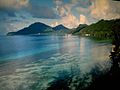
Mangareva seen from the lagoon

View from Mont Mokoto to Mangareva

View from Mangareva to the lagoon and the Motu Totegie
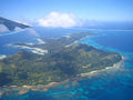
Mangareva from the air


Individual evidence
- ^ National Geographic Map: The earth's fractured surface , Washington, DC, supplement to the April 1995 issue
- ↑ JD Woodhead, MT McCulloch: Ancient seaflor signals in Pitcairn Island lavas and evidence for large amplitude, small length-scale mantle heterogeneities ; in: Earth and Planetary Science Letters, No. 94, 1989, pp. 257-273
- ↑ V. Cloutard & A. Bonneville: Ages of seamounts, islands and plateaus on the Pacific plate , Paris 2004
- ↑ a b Jared Diamond: Collapse. Why societies survive or perish. S. Fischer Verlag, Frankfurt am Main, 20053; ISBN 978-3-10-013904-7
- ^ A b c Peter H. Buck, Vikings of the Pacific, University of Chicago Press, 1938
- ^ SR Fischer: Mangarevan Doublets; Preliminary Evidence for Proto-Southeastern Polynesian ; in: Ozeanic Linguistics 41 (2002), pp. 225-231
- ↑ a b P.V. Kirch: On the Road of the Winds - An Archaeological History of the Pacific Islands before European Contact; Berkeley, Los Angeles, London, 2000
- ^ A b c Marshall Weisler: An Archaeological Survey of Mangareva: Implications for Regional Settlement Models and Interaction Studies; in: Man and Culture in Oceania 12 (1996)
- ^ Marshall Weisler: Provenance studies of Polynesian basalt adze material: a review and suggestions for improving regional data bases ; in: Asian Perspectives 32 (1993), pp. 61-83
- ↑ TR Hiroa: Ethnology of Mangareva, Berenice P. Bishop Museum Bulletin No. 157, Honolulu 1938
- ↑ Kenneth Pike Emory: Archeology of Mangareva and Neighboring Islands , Bernice P. Bishop Museum Bulletin 163, Honolulu 1939, p. 21
- ^ FW Beechey: Narrative of a Voyage to the Pacific and Bering's Strait, Volume 1; London 1831; P. 142 ff.
- ↑ H.-O. Meißner: Insel der Südsee, Munich 1987, p. 134 ff.
- ^ Institut Statistique de Polynésie Française (ISPF) - Recensement de la population 2012
- ^ JA del Busto: Tupac Yupanqui, Discoverer of Oceania, Lima 2000
- ^ Robert Lee Eskridge: Manga Reva - The Forgotten Islands ; Indianapolis 1931
Web links
- Information about Mangareva including video (French)
- Side of the Metropolitan Museum of Art on the religious art of Mangareva (English)
- Roger C. Green & Marshall I. Weisler: Mangarevan Archeology: Interpretations using new data and 40 year old excavations to establish a sequence from 1200 to 1900 AD (PDF)
literature
- Kenneth Pike Emory: Archeology of Mangareva and Neighboring Atolls. Bernice Pauahi Bishop Museum, Bulletin 163, 1939, 76 pages (Reprint 1971: ISBN 0-527-02271-3 , Reprint 1978: ISBN 978-0527022716 )