Rapa (municipality)
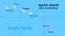
Rapa is a municipality in the extreme southeast of the Austral Islands , making it the southernmost municipality in French Polynesia . It comprises the island of Rapa Iti with an area of 40.57 km² as well as the uninhabited rock islands of Marotiri with an area of 4 hectares and is not divided into sub-communities ( communes associées ). The community has 482 inhabitants (as of 2007).
Info box
| country | Overseas region | Subdivision | Parish code | Post Code | Seat of the municipal administration (Mairie) |
|---|---|---|---|---|---|
| France | French Polynesia | Austral Islands | 98741 | 98751 | Ahurei (Haurei) (in Rapa Iti) |
| of inhabitants number |
was standing | Coordinates | Minimum height |
Maximum height |
total area |
|---|---|---|---|---|---|
| 482 | 2007 | 27 ° 36 ′ 24 ″ S , 144 ° 20 ′ 40 ″ W. | 0 | 650 | 40.61 km² |
Individual evidence
- ^ Institut Statistique de Polynésie Française (ISPF) - Recensement de la population 2007 ( Memento of February 29, 2008 in the Internet Archive ) (PDF; French)
Coordinates: 27 ° 36 ′ 24 ″ S , 144 ° 20 ′ 40 ″ W.
