Marutea North
| Marutea North | ||
|---|---|---|
| NASA image of Marutea Nord | ||
| Waters | Pacific Ocean | |
| archipelago | Tuamotu Archipelago | |
| Geographical location | 17 ° 7 ′ S , 143 ° 1 ′ W | |
|
|
||
| Number of islands | - | |
| Main island | - | |
| Land area | 2.7 km² | |
| Lagoon area | 458 km² | |
| Residents | uninhabited | |
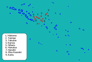
| Location of Marutea, red (6) | ||
Marutea, or Taunga tauranga-e-havana , is an atoll in the Tuamotu Archipelago of French Polynesia . It is located 24 km southeast of Makemo and 30 km southwest of Nihiru . Marutea Nord belongs to the Makemo municipality, which consists of the atolls Makemo, Haraiki , Marutea Nord, Katiu , Tuanake , Hiti , Tepoto Sud , Raroia , Takume , Taenga and Nihiru.
In places the atoll reaches a width of 17 km and a length of 42 km. Within the municipality of Makemo, Marutea Nord has the second largest lagoon area with 458 km², while the land area is only 2.7 km². The atoll is just above sea level and is often washed over by the sea; it is therefore uninhabited.
Taunga-tauranga-e-havana , the original name means something like "The beautiful bird that rests on our mast", at least that is the interpretation of a local from the Faaite Atoll . However, only fragments of this derivation are available.
Marutea Nord is not the neighboring atoll of Marutea Sud , which is located on the southern tip of the Tuamotu Archipelago.
The atoll was discovered by James Cook in 1773 . On some historical maps, Marutea was marked as "Furneaux Island".
Web links
- Image and short description (Engl.) ( Memento of 23 December 2010 at the Internet Archive )
- Exact coordinates
- Sharks in front of Marutea (Youtube)
- history
- Name interpretation


