Motutunga
| Motutunga | ||
|---|---|---|
| NASA image by Motutunga | ||
| Waters | Pacific Ocean | |
| archipelago | Tuamotu Archipelago | |
| Geographical location | 17 ° 6 ′ S , 144 ° 22 ′ W | |
|
|
||
| Number of islands | - | |
| Land area | 1.4 km² | |
| Lagoon area | 126 km² | |
| Residents | uninhabited | |
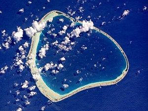
Motutunga belongs to the Anaa municipality , is an uninhabited atoll in the Tuamotu Archipelago in French Polynesia and is 17 km southeast of Tahanea . It is triangular in shape, 15 km long and 14 km wide, is surrounded by a fringing reef and the lagoon has no navigable access to the sea.
Motutunga was discovered by James Cook in 1773 and originally christened Adventure in the name of his ship . The Spanish navigator Domingo de Boenechea sighted the island in 1774 and named it San Blas .
Web links
- Picture and short description ( memento from December 23, 2010 in the Internet Archive )
- List Spanish sailors (English)

