Taenga
| Taenga | ||
|---|---|---|
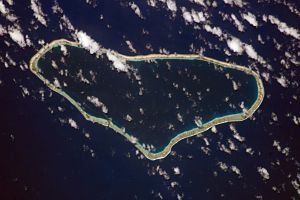
| NASA image of Taenga | ||
| Waters | Pacific Ocean | |
| archipelago | Tuamotu Archipelago | |
| Geographical location | 16 ° 21 ′ S , 143 ° 8 ′ W | |
|
|
||
| Number of islands | - | |
| Main island | - | |
| Land area | 20 km² | |
| Lagoon area | 140 km² | |
| Residents | 96 (2007) | |
Taenga or Taunga-hara is an atoll in the Tuamotu Archipelago in French Polynesia . Taenga is 32 km northeast of Makemo .
The atoll has a triangular shape, with sides of 27 km and 11 km respectively. The land area is about 20 km², the lagoon of the atoll has no navigable access to the sea. Taenga belongs to the municipality of Makemo and has 96 inhabitants (as of 2007) who live in the only place Henuparea . Most of the current residents are Mormons who settled on the island in the 19th century.
The Taenga Atoll was discovered by the Russian explorer Fabian Gottlieb von Bellingshausen in 1820. On some maps it is marked as Jermolow or Holt Island .
Web links
- Pictures and short story ( Memento from December 23, 2010 in the Internet Archive )
- Travel report about the atoll
- Mormon history in Taenga
Individual evidence
- ^ Institut Statistique de Polynésie Française (ISPF) - Recensement de la population 2007 ( Memento of February 29, 2008 in the Internet Archive ) (PDF, French)

