Tuanake
| Tuanake | ||
|---|---|---|
| NASA image by Tuanake | ||
| Waters | Pacific Ocean | |
| archipelago | Tuamotu Archipelago | |
| Geographical location | 16 ° 40 ′ S , 144 ° 13 ′ W | |
|
|
||
| Number of islands | - | |
| Main island | - | |
| Land area | 6 km² | |
| Lagoon area | 26 km² | |
| Residents | uninhabited | |
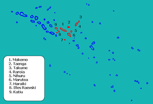
| Location of Tuanake (8) | ||
Tuanake (old name: Reid Island ) is an atoll in the Tuamotu Archipelago in French Polynesia . It is located 24 km southwest of Makemo. The atoll has a semicircular shape, approximately 9.5 km long and 5.5 km wide. The lagoon has navigable access to the sea in the southwest. The atoll forms together with Tepoto Sud and Hiti the group of Raevski Atolls . Tuanake belongs to the municipality of Makemo which consists of the atolls Makemo , Haraiki , Marutea North , Katiu , Tuanake, Hiti, Tepoto Sud, Raroia , Takume , Taenga and Nihiru .
Tuanake was discovered in 1820 by the Baltic German Fabian Gottlieb von Bellingshausen .
The atoll is home to the Polynesian earth dove and the Tuamotu warbler .
Web links
- Image and Quick description (Engl.) ( Memento of 23 December 2010 at the Internet Archive )
- Tuamotu reed warbler (English)
- Polynesian Earth Dove (PDF, 142 kB; English)


