Aratika
| Aratika | ||
|---|---|---|
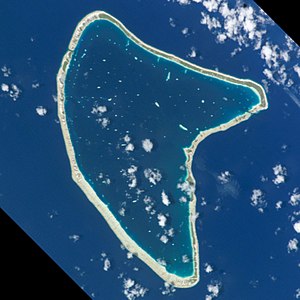
| NASA image of Aratika | ||
| Waters | Pacific Ocean | |
| archipelago | Tuamotu Archipelago | |
| Geographical location | 15 ° 32 ′ S , 145 ° 32 ′ W | |
|
|
||
| Number of islands | - | |
| Main island | - | |
| Land area | 8.3 km² | |
| Lagoon area | 145 km² | |
| Residents | 228 (2002) | |
| Map of Aratika | ||
Aratika is an atoll in the Tuamotu Archipelago in French Polynesia . Administratively, the atoll belongs to the municipality of Fakarava . Aratika is located 34 km northeast of Kauehi and 47 km northeast of Fakarava . The shape of the atoll resembles a butterfly, it reaches an area of 20.8 × 10.7 km. The deep, 145 km² large lagoon has two navigable accesses to the sea.
history
Aratika was discovered for Europe by Jakob Roggeveen in 1722 , but without landing there. He called the island "Carlshoff".
The atoll was approached on September 3, 1839 by Charles Wilkes as part of a research expedition.
The most important place on the island is Paparara , on the atoll there is a private airfield, which was opened in 1998. Aratika was bought by the Fourcade Company.
Web links
- Picture and short description ( memento from December 23, 2010 in the Internet Archive )
- Vacation pictures (French)
- Aratika North Airport (english)
- Information about Charles Wilkes (English)


