
Makemo
| Makemo | ||
|---|---|---|
 |
||
| Waters | Pacific Ocean | |
| archipelago | Tuamotu Archipelago | |
| Geographical location | 16 ° 38 ′ S , 143 ° 45 ′ W | |
|
||
| Number of islands | - | |
| Main island | Pouheva | |
| length | 69.7 km | |
| width | 16.9 km | |
| Land area | 56 km² | |
| Lagoon area | 600 km² | |
| Residents | 745 (2002) | |
 |
||

Makemo , Rangi-kemo or Te Paritua, is the fourth largest atoll in the Tuamotu Archipelago . It is 70 km long, between 7 and 17 km wide and extends over about 845 square kilometers.
geography
Numerous motu of the atoll lie along the north side of the atoll. They have dense vegetation. The atoll ring in the south is closed, but without a motu. The large lagoon has two navigable entrances. Passe Arikitamiro ( Passe Puheva ) is located immediately east of the main town in the east of the atoll.
The main town of the atoll is Pouheva in the east. In the far northwest there is another village, Ohava. Immediately to the east of this is the Passe Tapuhiria passage . Makemo Airport, which opened in 1976, is located eight kilometers northwest of the capital. There is a school for 150 children who also come from the surrounding atolls. The municipality of Makemo consists of the atolls Makemo, Haraiki , Marutea North , Katiu , Tuanake , Hiti , Tepoto Sud , Raroia , Takume , Taenga and Nihiru .
Legend
Makemo is considered the birthplace of the legendary hero Moeava. Legend has it that he was in love with Huarei, the island queen of Tepukamaruia . The giant Patira also desired the queen, and a duel for Huarei on Makemo Island ensued. Moeva reached the atoll first and, with the help of the god Tu, killed his opponent by throwing a large rock, which he had formed before his opponent arrived, at Patira's head. The stone that can still be seen on the island today is called Moeva.
history
The Makemo Atoll was discovered for Europe on March 10, 1803 by John Buyers, the captain of the British merchant ship Margaret . Buyers was involved in the salt meat trade between Port Jackson and Tahiti as well as other lucrative businesses in the Pacific. He named the uninhabited atoll Phillips Island.
The German-Baltic naval officer in Russian service Fabian Gottlieb von Bellingshausen reached the atoll on July 15, 1820 with the ships Mirny and Vostok and named it Prince Golenishchef Kutuzov Smolenskii Island. Makemo is therefore marked as “Kutuzov” or “Kotuzov” on old maps. Although Bellingshausen saw two men with a canoe on the beach, he thought the island was uninhabited, as he could see neither smoke nor any other signs of a settlement.
economy
Today (2011) the inhabitants live from pearl cultivation and tourism. In addition to the legendary Moeva rock and a whale sanctuary, you can visit the city's lighthouse , which replaces an old lighthouse of the Fakarava atoll .
The atoll is visited by cruise ships from time to time .
Picture gallery
- photos
Makemo Airfield
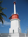
Makemo lighthouse

Makemo Beach
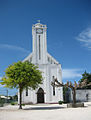
City Church
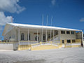
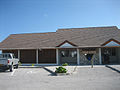
Makemo City Hall and Police Station
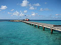
Makemo Harbor


literature
- Paumotu . In: Encyclopædia Britannica . 11th edition. tape 20 : Ode - Payment of Members . London 1911, p. 966 (English, full text [ Wikisource ]).
Web links
- Picture and short description ( memento from December 23, 2010 in the Internet Archive )
- Tourism information (English, French)
- Makemo Atoll Map (PDF)
- Map of the atoll
Individual evidence
- ^ John Dunmore: Who's who in Pacific navigation . University of Hawaii Press, Honolulu 1991, p. 44
- ^ John Turnbull and R. Phillips: A Voyage Round the World: In the Years 1800, 1801, 1802, 1803, and 1804, in Which the Author Visited the Principal Islands in the Pacific Ocean. T. Gillet, Salisbury 1805
- ^ Andrew Sharp: The Discovery of the Pacific Islands. Greenwood Press, Westport (CT) 1960, p. 196
Ahe | Ahunui | Akiaki | Amanu | Anaa | Anuanuraro | Anuanurunga | Apataki | Aratika | Arutua | Faaite | Fakahina | Fakarava | Fangatau | Fangataufa | Hao | Haraiki | Héréhérétué | Hikueru | Hiti | Katiu | Kauehi | Kaukura | Makatea | Makemo | Manihi | Manuhangi | Maria Est | Morocco | Marutea North | Marutea Sud | Mataiva | Matureivavao | Morane | Motutunga | Mururoa | Napuka | Nengonengo | Niau | Nihiru | Nukutavake | Nukutepipi | Paraoa | Pinaki | Puka-puka | Puka Rua | Rangiroa | Raraka | Raroia | Ravahere | Reao | Reitoru | Rekareka | Taenga | Tahanea | Taiaro | Takapoto | Takaroa | Takume | Tatakoto | Tauere | Tekokota | Tematangi | Temoe | Tenararo | Tenarunga | Tepoto North | Tepoto Sud | Tikehau | Tikei | Toau | Tuanake | Tureia | Vahanga | Vahitahi | Vairaatea | Vanavana