Ducie
| Ducie | |
|---|---|
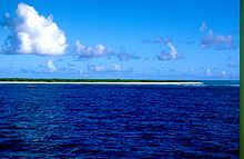
| NASA image of Ducie | |
| Waters | Pacific Ocean |
| archipelago | Pitcairn Islands |
| Geographical location | 24 ° 41 ′ S , 124 ° 48 ′ W |
| Number of islands | 4th |
| Main island | Acadia Island |
| length | 3 km |
| width | 2.3 km |
| Land area | 70 ha |
| Lagoon area | 2 km² |
| total area | 3.2 km² |
| Residents | uninhabited |
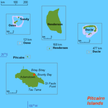
| Map of Ducie | |
Ducie , old name: La Encarnación or Incarnacion , is an uninhabited, sandy atoll belonging to the British archipelago of the Pitcairn Islands , about 540 kilometers east of Pitcairn at 24 ° 41 ′ south and 124 ° 47 ′ west in the Pacific . It is the southernmost atoll on earth.
geography
Ducie is formed from the islands of Acadia Island, Westward Island, Pandora Island and Edwards Island. They have a total area of 0.7 square kilometers. The total area of the atoll, which rises only a little above sea level, is 3.9 square kilometers including the lagoon .
The crescent-shaped, approximately 3.5 kilometers long main island Acadia Island is named after the British three- master Acadia , who was shipwrecked here on June 5, 1881 with a cargo of wheat. The survivors rowed in the open dinghies - with a stop on the also uninhabited Henderson - for 13 days to Pitcairn , where they were finally rescued. The anchor of the Acadia was lifted by divers of the World Discoverer in March 1990 and placed in front of the generator house together with a commemorative plaque on the occasion of the bicentenary of the settlement of Pitcairn.
flora
The vegetation consists of only two low-growing plant species:
- Pemphis acidula , a small tree with a reddish, hard wood, small leaves and small, white flowers
- Argusia argentea ( synonyms : Tournefortia argentea , now Heliotropium foertherianum ), a compact tree up to six meters high that belongs to the heliotropes (a subfamily of the predatory family ). The pointed, oval, glossy leaves grow in clusters at the ends of the branches. The salt-tolerant plant with small, white and strongly fragrant flowers forms a monospecific forest on the island.
fauna
The fauna of Ducie is species-poor because of the limited land area, the isolated location and the low biodiversity of the flora. Only 15 species of insects are known and described , plus a tick , six species of spiders , an isopod and a flea shrimp . Only two species of snail are known of the terrestrial molluscs : Melampus flavus and a Pacificella species.
14 different species of sea birds breed on Ducie. Ducie is the world's largest breeding colony of the Murphy petrel ( Pterodroma ultima ), between January and August over 250,000 birds nest here.
The lagoon, which is up to 15 meters deep and interspersed with many coral reefs , has a species-rich underwater flora. However, the largest populations of marine life are found in the flow channels between the islands, especially in the 100 meter wide and up to 80 meter deep passage between Westward and Pandora Island. The whitetip reef shark ( Triaenodon obesus ) is common in the Ducie area.
history
Apparently the island was never permanently inhabited by humans, and this should hardly have been possible due to the complete lack of fresh water sources. The occurrence of the Pacific rat ( Rattus exulans ), which was brought along and distributed by the Polynesian seafarers as a food animal, proves at least the temporary presence of Polynesians .
Ducie was discovered on January 26, 1606 by the Portuguese navigator Pedro Fernández de Quirós . It was the first island that Quirós sighted after leaving Callao on December 21, 1605. He initially called the atoll "Luna Puesta" (moonset) in his 1609 memorandum to King Philip III. However, he changed the name to the Christian "La Encarnación" ( Incarnation ).
The archipelago received its current name from Captain Edward Edwards of the frigate HMS Pandora , which had been sent to search for the mutineers of the Bounty . The Pandora reached Ducie on March 16, 1791, but Edwards - like Quirós before him - did not go ashore. He named the atoll after the Earl of Ducie, who belonged to the Peers of the United Kingdom . Edwards had been sponsored by the noble family.
During his expedition to the Pacific and Arctic North America, the British explorer Frederick William Beechey visited the islands of Pitcairn and Henderson and reached Ducie on November 28, 1825. He did not land, but sent a dinghy for sounding . His measurements were the basis for the first map of the island ( British Admiralty Chart No. 1176 ). This would be Ducie's only card for over 100 years.
“Ducie's island is a coral formation of oval shape with a lagoon or a lake in the middle, which barely reaches above sea level. The height of the solid land is about 12 feet [3.6 meters], with trees about 14 feet [4.3 meters] tall, making the highest elevation 26 feet [7.9 meters] above sea level. The lagoon appears to be deep and has an entrance for a small boat when the sea is calm enough to allow entry. The passage is in the extreme south-east * , to the right of two humps that appear to be sandbanks. The island extends northeast to southwest, is one and three quarters of a mile long and a mile wide. We didn't see any living thing except birds, but the area seems to be teeming with fish and there are countless sharks. The water was so clear over the coral reef that we could still see the sea floor even if we were no longer sounding at 30 fathoms [54.8 meters]. At a depth of 24 fathoms [43.9 meters], a coral block stood out clearly on the sea floor. The corals came in all shapes and sizes, mostly white, yellow, and purple, making the seabed look variegated, but they also faded very quickly when they were peeled off. With the soundings around the island, we had the impression that, seen from a distance, it had the curved shape of a flat dome. "
The first European to set foot on Ducie was the British naturalist and malacologist Hugh Cuming , who, coming from Easter Island on his ship Discoverer , reached Ducie on December 7, 1827.
Citing the Guano Islands Act , the United States began claiming ownership in 1867.
Under the direction of Robert Teesdale Simons, British Consul of Tahiti and Deputy Commissioner for the Western Pacific from 1894 to 1908, the Adventist cutter Pitcairn sailed from the island of Pitcairn to Oeno , Henderson and Ducie under the command of Captain GF Jones . On December 19, 1902, the crew left a plaque on Ducie that read: "This island is a Pitcairn colony and is owned by the British Government."
The first well-prepared scientific expedition on Ducie was the Whitney South Seas Expedition of the American Museum of Natural History , whose primary goal was the collecting of bird preparations on various Pacific islands. The scientists who reached Ducie with the schooner France on March 19, 1922, stayed twelve days and carried out extensive studies of the flora and fauna.
In August 1937, the British-New Zealand light cruiser HMNZS Leander visited the islands of Oeno, Ducie and Henderson to renew the British Crown’s claim to the islands. The crew hoisted the Union Jack on Ducie and left a badge. The aircraft on board took the first aerial photographs of the island, on the basis of which the US Navy Hydrographic Office made a new map of the island.
So far there have been only a few scientific expeditions to Ducie. Worth mentioning are the National Geographic Society-Oceanic Institute Expedition to Southeast Oceania from 1971, the Operation Raleigh Pacific Island Expedition from 1987 and the Sir Peter Scott Commemorative Expedition to the Pitcairn Islands from January 1991 to April 1992, the 20 scientists from different disciplines also after Ducie brought.
Cruise ships that are on their way to Easter Island only pass the atoll.
Web links
Individual evidence
- ^ Robert Irving, Terry Dawson: The Marine Environment of the Pitcairn Islands . A report to Global Ocean Legacy, a project of the Pew Environment Group . Dundee University Press, Dundee 2012, ISBN 978-1-84586-161-2 , 3.4 Ducie - Key Facts, pp. 33 (English, pewtrusts.org [PDF; 3.6 MB ; accessed on June 14, 2020]).
- ^ Jacques Florence et al .: The flora of the Pitcairn Islands: a review . In: Biological Journal of the Linnean Society . tape 56 , no. 1-2 . Oxford University Press, September 1995, ISSN 0024-4066 , pp. 79–119 , p. 83: Ducie Island , doi : 10.1111 / j.1095-8312.1995.tb01079.x (English).
- ↑ Tim G. Benton : Biodiversity and biogeography of Henderson Island's insects . In: Biological Journal of the Linnean Society . tape 56 , no. 1-2 . Oxford University Press, September 1995, ISSN 0024-4066 , pp. 245-259 , pp. 254-255: Collections of insects on Ducie Atoll , doi : 10.1111 / j.1095-8312.1995.tb01089.x (English).
- ^ Richard C. Preece: Systematic review of the land snails of the Pitcairn Islands . In: Biological Journal of the Linnean Society . tape 56 , no. 1-2 . Oxford University Press, September 1995, ISSN 0024-4066 , pp. 273-307 , p. 305: Table 3. Synoptic list of the land snails and semi-terrestrial molluscs from the Pitcairn Islands , doi : 10.1111 / j.1095-8312.1995.tb01091.x (English).
- ^ Marshall I. Weisler: Henderson Island prehistory: colonization and extinction on a remote Polynesian island . In: Biological Journal of the Linnean Society . tape 56 , no. 1-2 , September 1995, ISSN 0024-4066 , pp. 377–404 , here p. 384: Ducie , doi : 10.1111 / j.1095-8312.1995.tb01099.x (English).
- ↑ Clements Markham (ed.): The voyages of Pedro Fernandez de Quiros, 1595 to 1606 . tape 1 . The Hakluyt Society, London 1904, III. Narrative of the Voyage of Pedro Fernandez de Quiros in 1606, for the Discovery of the Austrial Regions - Chapter V, p. 191–192 (English, full text ).
- ↑ Clements Markham (ed.): The voyages of Pedro Fernandez de Quiros, 1595 to 1606 . tape 2 . The Hakluyt Society, London 1904, Appendix II. - Memorial of Quiros, 1609, p. 487–503 , here table p. 487 (English, full text ).
- ↑ Harald A. Rehder, John E. Randall: Ducie Atoll: Its history, physiography and biota . In: Atoll Research Bulletin . No. 183 , Jan. 15, 1975, ISSN 0077-5630 , History, pp. 2-9 , doi : 10.5479 / si.00775630.183.1 (English).
- ↑ Frederick William Beechey : Narrative of a voyage to the Pacific and Beering's strait, to co-operate with the polar expeditions: performed in His Majesty's ship Blossom, under the command of Captain FW Beechey, RN, FRS & c. in the years 1825, 26, 27, 28 . tape 1 . Henry Colburn and Richard Bentley, London 1831, Chapter II, p. 35–65 , here pp. 59–61 (English, full text ).
- ↑ Harold St. John: Itinerary of Hugh Cuming in Polynesia ; Honolulu 1940; Pp. 81-90
- ↑ James S. Wallace: The 'Pitcairn' Ship and Her Six Voyages , Berrien Springs (MI), 1972


