Chitose
| Chitose-shi 千 歳 市 |
||
|---|---|---|
| Geographical location in Japan | ||
|
|
||
| Region : | Hokkaidō | |
| Prefecture : | Hokkaidō | |
| Coordinates : | 42 ° 49 ' N , 141 ° 39' E | |
| Basic data | ||
| Surface: | 594.95 km² | |
| Residents : | 97,483 (September 30, 2019) |
|
| Population density : | 164 inhabitants per km² | |
| Community key : | 01224-6 | |
| Symbols | ||
| Flag / coat of arms: | ||
| Tree : | Cake trees | |
| Flower : | Azaleas | |
| town hall | ||
| Address : |
Chitose City Hall 2 - 34 Shinonome-chō Chitose -shi Hokkaidō 066-8686 |
|
| Website URL: | http://www.city.chitose.hokkaido.jp | |
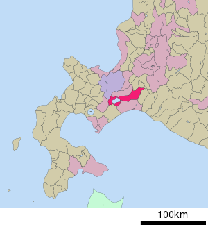
| Location Chitoses in Hokkaidō Prefecture | ||
Chitose ( Japanese 千 歳 市 , - shi ) is a city in the Ishikari sub-prefecture on the island of Hokkaidō ( Japan ).
geography
Chitose is south of Sapporo . The westernmost part of the urban area around Shikotsu Lake belongs to the Shikotsu-Tōya National Park .
traffic
In the urban area of Chitose is the New Chitose Airport, Hokkaidō's most important airport, which also opens up the prefecture capital Sapporo.
The Chitose Line runs through the city with Chitose and Minami-Chitose stations . The latter is the starting point of the Sekishō line to the east of the island and the branch line to the New Chitose airport station .
Chitose can be reached via the Dōō motorway and national roads 36, 234, 274, 276, 337 and 453.
Town twinning
sons and daughters of the town
- Chiyotaikai Ryūji (* 1976), sumo wrestler
- Masako Hozumi (* 1986), speed skater
Neighboring cities and communities
Web links
Commons : Chitose - collection of images, videos and audio files


