
Chitose line
| Chitose line | |||||||||||||||||||||||||||||||||||||||||||||||||||||||||||||||||||||||||||||||||||||||||||||||||||||||||||||||||||||||||||||||||||||||||||||||||||||||||||||||||||||||||||||||||||||||||||||||||||||||||||||||||
|---|---|---|---|---|---|---|---|---|---|---|---|---|---|---|---|---|---|---|---|---|---|---|---|---|---|---|---|---|---|---|---|---|---|---|---|---|---|---|---|---|---|---|---|---|---|---|---|---|---|---|---|---|---|---|---|---|---|---|---|---|---|---|---|---|---|---|---|---|---|---|---|---|---|---|---|---|---|---|---|---|---|---|---|---|---|---|---|---|---|---|---|---|---|---|---|---|---|---|---|---|---|---|---|---|---|---|---|---|---|---|---|---|---|---|---|---|---|---|---|---|---|---|---|---|---|---|---|---|---|---|---|---|---|---|---|---|---|---|---|---|---|---|---|---|---|---|---|---|---|---|---|---|---|---|---|---|---|---|---|---|---|---|---|---|---|---|---|---|---|---|---|---|---|---|---|---|---|---|---|---|---|---|---|---|---|---|---|---|---|---|---|---|---|---|---|---|---|---|---|---|---|---|---|---|---|---|---|---|---|
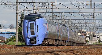
 Type 733 multiple unit on the Chitose Line
| |||||||||||||||||||||||||||||||||||||||||||||||||||||||||||||||||||||||||||||||||||||||||||||||||||||||||||||||||||||||||||||||||||||||||||||||||||||||||||||||||||||||||||||||||||||||||||||||||||||||||||||||||
 | |||||||||||||||||||||||||||||||||||||||||||||||||||||||||||||||||||||||||||||||||||||||||||||||||||||||||||||||||||||||||||||||||||||||||||||||||||||||||||||||||||||||||||||||||||||||||||||||||||||||||||||||||
| Route length: | 56.6 km + 2.6 km | ||||||||||||||||||||||||||||||||||||||||||||||||||||||||||||||||||||||||||||||||||||||||||||||||||||||||||||||||||||||||||||||||||||||||||||||||||||||||||||||||||||||||||||||||||||||||||||||||||||||||||||||||
| Gauge : | 1067 mm ( cape track ) | ||||||||||||||||||||||||||||||||||||||||||||||||||||||||||||||||||||||||||||||||||||||||||||||||||||||||||||||||||||||||||||||||||||||||||||||||||||||||||||||||||||||||||||||||||||||||||||||||||||||||||||||||
| Power system : | 20 kV 50 Hz ~ | ||||||||||||||||||||||||||||||||||||||||||||||||||||||||||||||||||||||||||||||||||||||||||||||||||||||||||||||||||||||||||||||||||||||||||||||||||||||||||||||||||||||||||||||||||||||||||||||||||||||||||||||||
| Top speed: | 130 km / h | ||||||||||||||||||||||||||||||||||||||||||||||||||||||||||||||||||||||||||||||||||||||||||||||||||||||||||||||||||||||||||||||||||||||||||||||||||||||||||||||||||||||||||||||||||||||||||||||||||||||||||||||||
| Dual track : | Numanohata - Shiroishi | ||||||||||||||||||||||||||||||||||||||||||||||||||||||||||||||||||||||||||||||||||||||||||||||||||||||||||||||||||||||||||||||||||||||||||||||||||||||||||||||||||||||||||||||||||||||||||||||||||||||||||||||||
| Society: | JR Hokkaido | ||||||||||||||||||||||||||||||||||||||||||||||||||||||||||||||||||||||||||||||||||||||||||||||||||||||||||||||||||||||||||||||||||||||||||||||||||||||||||||||||||||||||||||||||||||||||||||||||||||||||||||||||
|
|||||||||||||||||||||||||||||||||||||||||||||||||||||||||||||||||||||||||||||||||||||||||||||||||||||||||||||||||||||||||||||||||||||||||||||||||||||||||||||||||||||||||||||||||||||||||||||||||||||||||||||||||
The Chitose Line ( Japanese 千 歳 線 , Chitose-sen ) is a railway line on the Japanese island of Hokkaidō , which is operated by the Hokkaido Railway Company (JR Hokkaido). It connects Sapporo with Numanohata at Tomakomai . The Chitose Line also includes a branch line that connects New Chitose Airport to the rail network. The Chitose line was opened in 1926 and in 1973 was partially re-routed, and the airport shuttle was added in 1992.
description


The Chitose Line includes a main line and a branch line, both of which are laid in Cape Gauge (1067 mm). The former is 56.6 km long; it begins at Shiroishi Station in the east of Sapporo, where it branches off the Hakodate main line. It then heads south via Chitose to Numanohata station near Tomakomai , where it meets the Muroran main line . The 2.6 km long branch line runs mainly in a tunnel and connects the Minami-Chitose Station to the airport station of the airport New Chitose .
The entire length of the Chitose Line is electrified with 20 kV 50 Hz alternating voltage and, with the exception of the airport feeder, has two tracks. 16 train stations and stops will be developed for passenger transport, and JR Freight also operates a freight station .
Trains
The Chitose Line forms part of the trunk route between Sapporo, the south of Hokkaidō and (since the opening of the Seikan tunnel ) the main island of Honshū . It also plays an important role in local transport in the metropolis of Sapporo and enables access to destinations in the east of the island. For these reasons, it is the busiest railway line in Hokkaidō.
The diesel- powered express trains Hokuto and Super Hokuto run from Sapporo to Hakodate about every one to two hours , supplemented by the electric Suzuran express trains to Muroran . As far as Minami-Chitose, the Chitose line is shared by the diesel express trains Super Ōzora to Kushiro and Super Tokachi to Obihiro. The Airport Liner runs from the airport to Sapporo every 15 minutes (every second train continues to Otaru ). All sleeper trains have been discontinued: Hokutosei and Twilight Express in 2015, Cassiopeia and Hamanasu in 2016. In local transport, regional trains run at frequent intervals between Sapporo and Tomakomai .
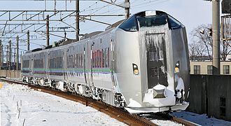
Super Ōzora at Shiroishi
Airport liner in Chitose

Local train at Kita-Hiroshima

Freight train on the Chitose Line


history
In the first few decades, Hokkaidō's railway network was mainly geared towards transporting coal from the mining areas as directly as possible to the ports on the Pacific coast. For this reason there was initially no direct connection between Sapporo and Tomakomai , which is why travelers between the two cities had to accept a longer detour via Iwamizawa . The private railway company Hokkaidō Tetsudō closed this gap on August 21, 1926 with the opening of the Sapporo Line ( 札幌 線 , Sapporo-sen ) from Naebo / Shiroishi near Sapporo to Numanohata . The northernmost section to Higashisapporo had already been created six years earlier as part of the Jōzankei railway line .
On July 25, 1931, the Naebo – Higashisapporo section was electrified (1500 V DC ), but this only affected the trains on the Jōzankei railway line. From October 26, 1940, the trains on the Sapporo line ran via Naebo to Sapporo Central Station . During the Pacific War , the Ministry of Railways wanted to bring some private railways under its control, which had been established after the first wave of nationalization in 1906/07 . This also affected the Hokkaidō Tetsudō, which was nationalized on August 1, 1943. On this day the Ministry of Railways introduced the name Chitose Line, which is still used today.
The Japanese State Railways responsible from 1949 continued the conversion to diesel traction that had begun before the war ; this measure was completed on June 1, 1955. On October 1, 1957, the Jōzankei railway line was withdrawn from Naebo to Higashisapporo, whereupon the direct current overhead line was removed there. Gradually the Chitose Line gained importance, for example in 1959 with the introduction of the first express trains. In stages, the state railway expanded the line to double track: 1965 between Chitose and Eniwa, 1966 between Eniwa and Kita-Hiroshima, 1968 between Uenae and Chitose and 1969 between Uenae and Numanohata.
The single-track, winding section from Naebo via Ōyachi to Kita-Hiroshima was a bottleneck, which is why the state railway replaced it with a straighter, double-track new line via Shin-Sapporo . It was opened on September 9, 1973; the old route was closed the next day and later converted into a cycle path . On October 1, 1980, the state railway electrified the entire Chitose line and opened the Minami-Chitose station on the same day . This is the starting point of the Sekishō line , opened on October 1, 1981 , which connects Sapporo more directly with the east of Hokkaidō. In the course of the privatization of the state railway, the Chitose line passed on April 1, 1987 into the possession of the new company JR Hokkaido .
In 1990, construction began on the branch line from Minami-Chitose to New Chitose Airport Station . It was planned in cooperation with the Danish State Railways and opened on July 1, 1992. In a short period of time, the airport feeder became the most profitable part of the JR Hokkaido network.
List of train stations
| Surname | km | Connecting lines | location | place | ||
|---|---|---|---|---|---|---|
| Chitose line | ||||||
| H17 | Numanohata ( 沼 ノ 端 ) | 0.0 | Muroran main line | Coord. | Tomakomai | |
| H16 | Uenae ( 植苗 ) | 6.4 | Coord. | |||
| H15 | Bibi ( 美 々 ) | 13.9 | Coord. | Chitose | ||
| H14 | Minami chitose ( 南 千 歳 ) | 18.4 | Airport branch line Sekishō Line |
Coord. | ||
| H13 | Chitose ( 千 歳 ) | 21.4 | Coord. | |||
| H12 | Osatsu ( 長 都 ) | 24.9 | Coord. | |||
| H11 | Sapporo Beer Teien ( サ ッ ポ ロ ビ ー ル 庭園 ) | 27.1 | Coord. | Eniwa | ||
| H10 | Eniwa ( 恵 庭 ) | 29.4 | Coord. | |||
| H09 | Megumino ( 恵 み 野 ) | 31.9 | Coord. | |||
| H08 | Shimamatsu ( 島 松 ) | 34.1 | Coord. | |||
| H07 | Kita-Hiroshima ( 北 広 島 ) | 40.6 | Coord. | Kitahiroshima | ||
| H06 | Kami-Nopporo ( 上 野 幌 ) | 48.6 | Coord. | Atsubetsu-ku , Sapporo | ||
| H05 | Shin-Sapporo ( 新 札幌 ) | 51.5 | Sapporo subway | Coord. | ||
| H04 | Heiwa ( 平和 ) | 54.4 | Coord. | Shiroishi-ku , Sapporo | ||
| H03 | Shiroishi ( 白石 ) | 56.6 | Hakodate main line | Coord. | ||
| Hakodate main line | ||||||
| H02 | Naebo ( 苗 穂 ) | 60.2 | Coord. | Chūō-ku , Sapporo | ||
| 01 | Sapporo ( 札幌 ) | 62.4 |
Hakodate Main Line Sasshō Line Sapporo Subway |
Coord. | ||
| Airport branch line | ||||||
| H14 | Minami chitose ( 南 千 歳 ) | 0.0 | Chitose Line (Main Line) Sekishō Line |
Chitose | ||
| AP15 | Shin-Chitose Kūkō ( 新 千 歳 空港 ) | 2.6 | Coord. | |||
Web links
Individual evidence
- ↑ a b c d Kazuo Tanaka: 写真 で 見 る 北海道 の 鉄 道 (Hokkaidō's railroad in photos) . tape 1 . Hokkaidō Shinbunsha, Sapporo 2002, ISBN 978-4-89453-220-5 , pp. 122-123 .
- ↑ Tanaka: 写真 で 見 る 北海道 の 鉄 道, p. 248.
- ↑ Tanaka: 写真 で 見 る 北海道 の 鉄 道, pp. 36–37.
- ↑ JR Hokkaido: 20 Years After JNR Privatization Vol. 2 - Increasing Efforts to Strengthen Position as Leading Transportation Provider in Hokkaido. (PDF, 1.3 MB) (No longer available online.) In: Japan Railway & Transport Review 49th East Japan Railway Culture Foundation, March 2008, p. 14 , archived from the original on March 4, 2016 ; accessed on July 24, 2016 . Info: The archive link was inserted automatically and has not yet been checked. Please check the original and archive link according to the instructions and then remove this notice.
Current lines: Hokkaidō-Shinkansen | Chitose line | Furano line | Hakodate main line | Hidaka main line | Kaikyō Line | Muroran main line | Nemuro main line | Rumoi main line | Sasshō Line | Sekihoku main line | Sekishō Line | Senmō main line | Sōya main line
Released Lines: Chihoku Line | Esashi line
Disused Lines: Horonai Line | Kamisunagawa branch line | Matsumae line | Nayoro main line | Shibetsu line | Shinmei line | Tenpoku Line | Utashinai line