
Hakodate main line
| Hakodate main line | |||||||||||||||||||||||||||||||||||||||||||||||||||||||||||||||||||||||||||||||||||||||||||||||||||||||||||||||||||||||||||||||||||||||||||||||||||||||||||||||||||||||||||||||||||||||||||||||||||||||||||||||||||||||||||||||||||||||||||||||||||||||||||||||||||||||||||||||||||||||||||||||||||||||||||||||||||||||||||||||||||||||||||||||||||||||||||||||||||||||||||||||||||||||||||||||||||||||||||||||||||||||||||||||||||||||||||||||||||||||||||||||||||||||||||||||||||||||||||||||||||||||||||||||||||||||||||||||||||||||||||||||||||||||||||||||||||||||||||||||||||||||||||||||||||||||||||||||||||||||||||||||||||||||||||||||||||||||||||||||||||||||||||||||||||||||||||||||||||||||||||||||||||||||||||||||||||||||||||||||||||||||||||||||||||||||||||||||||||||||||||||||||||||||||||||||||||||||||||||||||||||||||||||||||||||||||||||||||||||||||||||||||||||||||||||||||||||||||||||||||||||||||||||||||||||||||||||||||||||||||||||||||||||||||||||||||||||||||||||||||
|---|---|---|---|---|---|---|---|---|---|---|---|---|---|---|---|---|---|---|---|---|---|---|---|---|---|---|---|---|---|---|---|---|---|---|---|---|---|---|---|---|---|---|---|---|---|---|---|---|---|---|---|---|---|---|---|---|---|---|---|---|---|---|---|---|---|---|---|---|---|---|---|---|---|---|---|---|---|---|---|---|---|---|---|---|---|---|---|---|---|---|---|---|---|---|---|---|---|---|---|---|---|---|---|---|---|---|---|---|---|---|---|---|---|---|---|---|---|---|---|---|---|---|---|---|---|---|---|---|---|---|---|---|---|---|---|---|---|---|---|---|---|---|---|---|---|---|---|---|---|---|---|---|---|---|---|---|---|---|---|---|---|---|---|---|---|---|---|---|---|---|---|---|---|---|---|---|---|---|---|---|---|---|---|---|---|---|---|---|---|---|---|---|---|---|---|---|---|---|---|---|---|---|---|---|---|---|---|---|---|---|---|---|---|---|---|---|---|---|---|---|---|---|---|---|---|---|---|---|---|---|---|---|---|---|---|---|---|---|---|---|---|---|---|---|---|---|---|---|---|---|---|---|---|---|---|---|---|---|---|---|---|---|---|---|---|---|---|---|---|---|---|---|---|---|---|---|---|---|---|---|---|---|---|---|---|---|---|---|---|---|---|---|---|---|---|---|---|---|---|---|---|---|---|---|---|---|---|---|---|---|---|---|---|---|---|---|---|---|---|---|---|---|---|---|---|---|---|---|---|---|---|---|---|---|---|---|---|---|---|---|---|---|---|---|---|---|---|---|---|---|---|---|---|---|---|---|---|---|---|---|---|---|---|---|---|---|---|---|---|---|---|---|---|---|---|---|---|---|---|---|---|---|---|---|---|---|---|---|---|---|---|---|---|---|---|---|---|---|---|---|---|---|---|---|---|---|---|---|---|---|---|---|---|---|---|---|---|---|---|---|---|---|---|---|---|---|---|---|---|---|---|---|---|---|---|---|---|---|---|---|---|---|---|---|---|---|---|---|---|---|---|---|---|---|---|---|---|---|---|---|---|---|---|---|---|---|---|---|---|---|---|---|---|---|---|---|---|---|---|---|---|---|---|---|---|---|---|---|---|---|---|---|---|---|---|---|---|---|---|---|---|---|---|---|---|---|---|---|---|---|---|---|---|---|---|---|---|---|---|---|---|---|---|---|---|---|---|---|---|---|---|---|---|---|---|---|---|---|---|---|---|---|---|---|---|---|---|---|---|---|---|---|---|---|---|---|---|---|---|---|---|---|---|---|---|---|---|---|---|---|---|---|---|---|---|---|---|---|---|---|---|---|---|---|---|---|---|---|---|---|---|---|---|---|---|---|---|---|---|---|---|---|---|---|---|---|---|---|---|---|---|---|---|---|---|---|---|---|---|---|---|---|---|---|---|---|---|---|---|---|---|---|---|---|---|---|---|---|---|---|---|---|---|---|---|---|---|---|---|---|---|---|---|---|---|---|---|---|---|---|---|---|---|---|---|---|---|---|---|---|---|---|---|---|---|---|---|---|---|---|---|---|---|---|---|---|---|---|---|---|---|---|---|---|---|---|---|---|---|---|---|---|---|---|---|---|---|---|---|---|---|---|---|---|---|---|---|---|---|---|---|---|---|---|---|---|---|---|---|---|---|---|---|---|---|---|---|---|---|---|---|---|---|---|---|---|---|---|---|---|---|---|---|---|---|---|---|---|---|---|---|---|---|---|---|---|---|---|---|---|---|---|---|---|---|---|---|---|---|---|---|---|---|---|---|---|---|---|---|---|---|---|---|---|---|---|---|---|---|---|---|---|---|---|---|---|---|---|---|---|---|---|---|---|---|---|---|---|---|---|---|---|---|---|---|---|---|---|---|---|---|---|---|---|---|---|---|---|---|---|---|---|---|---|---|---|---|---|---|---|---|---|---|---|---|---|---|---|---|---|---|---|---|---|---|---|---|---|---|---|---|---|---|---|---|---|---|---|---|---|---|---|---|---|---|---|---|---|---|---|---|---|---|---|---|---|---|---|---|---|---|---|---|---|---|---|---|---|---|---|---|---|---|---|---|---|---|---|---|---|---|---|---|---|---|---|---|---|---|---|---|---|---|---|---|---|---|---|---|---|---|---|---|---|---|---|---|---|---|---|---|---|---|---|---|---|---|---|---|---|---|
 Class 789 multiple unit on the Hakodate main line
| |||||||||||||||||||||||||||||||||||||||||||||||||||||||||||||||||||||||||||||||||||||||||||||||||||||||||||||||||||||||||||||||||||||||||||||||||||||||||||||||||||||||||||||||||||||||||||||||||||||||||||||||||||||||||||||||||||||||||||||||||||||||||||||||||||||||||||||||||||||||||||||||||||||||||||||||||||||||||||||||||||||||||||||||||||||||||||||||||||||||||||||||||||||||||||||||||||||||||||||||||||||||||||||||||||||||||||||||||||||||||||||||||||||||||||||||||||||||||||||||||||||||||||||||||||||||||||||||||||||||||||||||||||||||||||||||||||||||||||||||||||||||||||||||||||||||||||||||||||||||||||||||||||||||||||||||||||||||||||||||||||||||||||||||||||||||||||||||||||||||||||||||||||||||||||||||||||||||||||||||||||||||||||||||||||||||||||||||||||||||||||||||||||||||||||||||||||||||||||||||||||||||||||||||||||||||||||||||||||||||||||||||||||||||||||||||||||||||||||||||||||||||||||||||||||||||||||||||||||||||||||||||||||||||||||||||||||||||||||||||||
 | |||||||||||||||||||||||||||||||||||||||||||||||||||||||||||||||||||||||||||||||||||||||||||||||||||||||||||||||||||||||||||||||||||||||||||||||||||||||||||||||||||||||||||||||||||||||||||||||||||||||||||||||||||||||||||||||||||||||||||||||||||||||||||||||||||||||||||||||||||||||||||||||||||||||||||||||||||||||||||||||||||||||||||||||||||||||||||||||||||||||||||||||||||||||||||||||||||||||||||||||||||||||||||||||||||||||||||||||||||||||||||||||||||||||||||||||||||||||||||||||||||||||||||||||||||||||||||||||||||||||||||||||||||||||||||||||||||||||||||||||||||||||||||||||||||||||||||||||||||||||||||||||||||||||||||||||||||||||||||||||||||||||||||||||||||||||||||||||||||||||||||||||||||||||||||||||||||||||||||||||||||||||||||||||||||||||||||||||||||||||||||||||||||||||||||||||||||||||||||||||||||||||||||||||||||||||||||||||||||||||||||||||||||||||||||||||||||||||||||||||||||||||||||||||||||||||||||||||||||||||||||||||||||||||||||||||||||||||||||||||||
| Route length: | 423.1 km + 35.3 km | ||||||||||||||||||||||||||||||||||||||||||||||||||||||||||||||||||||||||||||||||||||||||||||||||||||||||||||||||||||||||||||||||||||||||||||||||||||||||||||||||||||||||||||||||||||||||||||||||||||||||||||||||||||||||||||||||||||||||||||||||||||||||||||||||||||||||||||||||||||||||||||||||||||||||||||||||||||||||||||||||||||||||||||||||||||||||||||||||||||||||||||||||||||||||||||||||||||||||||||||||||||||||||||||||||||||||||||||||||||||||||||||||||||||||||||||||||||||||||||||||||||||||||||||||||||||||||||||||||||||||||||||||||||||||||||||||||||||||||||||||||||||||||||||||||||||||||||||||||||||||||||||||||||||||||||||||||||||||||||||||||||||||||||||||||||||||||||||||||||||||||||||||||||||||||||||||||||||||||||||||||||||||||||||||||||||||||||||||||||||||||||||||||||||||||||||||||||||||||||||||||||||||||||||||||||||||||||||||||||||||||||||||||||||||||||||||||||||||||||||||||||||||||||||||||||||||||||||||||||||||||||||||||||||||||||||||||||||||||||||||
| Gauge : | 1067 mm ( cape track ) | ||||||||||||||||||||||||||||||||||||||||||||||||||||||||||||||||||||||||||||||||||||||||||||||||||||||||||||||||||||||||||||||||||||||||||||||||||||||||||||||||||||||||||||||||||||||||||||||||||||||||||||||||||||||||||||||||||||||||||||||||||||||||||||||||||||||||||||||||||||||||||||||||||||||||||||||||||||||||||||||||||||||||||||||||||||||||||||||||||||||||||||||||||||||||||||||||||||||||||||||||||||||||||||||||||||||||||||||||||||||||||||||||||||||||||||||||||||||||||||||||||||||||||||||||||||||||||||||||||||||||||||||||||||||||||||||||||||||||||||||||||||||||||||||||||||||||||||||||||||||||||||||||||||||||||||||||||||||||||||||||||||||||||||||||||||||||||||||||||||||||||||||||||||||||||||||||||||||||||||||||||||||||||||||||||||||||||||||||||||||||||||||||||||||||||||||||||||||||||||||||||||||||||||||||||||||||||||||||||||||||||||||||||||||||||||||||||||||||||||||||||||||||||||||||||||||||||||||||||||||||||||||||||||||||||||||||||||||||||||||||
| Power system : | partly 20 kV 50 Hz ~ | ||||||||||||||||||||||||||||||||||||||||||||||||||||||||||||||||||||||||||||||||||||||||||||||||||||||||||||||||||||||||||||||||||||||||||||||||||||||||||||||||||||||||||||||||||||||||||||||||||||||||||||||||||||||||||||||||||||||||||||||||||||||||||||||||||||||||||||||||||||||||||||||||||||||||||||||||||||||||||||||||||||||||||||||||||||||||||||||||||||||||||||||||||||||||||||||||||||||||||||||||||||||||||||||||||||||||||||||||||||||||||||||||||||||||||||||||||||||||||||||||||||||||||||||||||||||||||||||||||||||||||||||||||||||||||||||||||||||||||||||||||||||||||||||||||||||||||||||||||||||||||||||||||||||||||||||||||||||||||||||||||||||||||||||||||||||||||||||||||||||||||||||||||||||||||||||||||||||||||||||||||||||||||||||||||||||||||||||||||||||||||||||||||||||||||||||||||||||||||||||||||||||||||||||||||||||||||||||||||||||||||||||||||||||||||||||||||||||||||||||||||||||||||||||||||||||||||||||||||||||||||||||||||||||||||||||||||||||||||||||||
| Top speed: | 120 km / h | ||||||||||||||||||||||||||||||||||||||||||||||||||||||||||||||||||||||||||||||||||||||||||||||||||||||||||||||||||||||||||||||||||||||||||||||||||||||||||||||||||||||||||||||||||||||||||||||||||||||||||||||||||||||||||||||||||||||||||||||||||||||||||||||||||||||||||||||||||||||||||||||||||||||||||||||||||||||||||||||||||||||||||||||||||||||||||||||||||||||||||||||||||||||||||||||||||||||||||||||||||||||||||||||||||||||||||||||||||||||||||||||||||||||||||||||||||||||||||||||||||||||||||||||||||||||||||||||||||||||||||||||||||||||||||||||||||||||||||||||||||||||||||||||||||||||||||||||||||||||||||||||||||||||||||||||||||||||||||||||||||||||||||||||||||||||||||||||||||||||||||||||||||||||||||||||||||||||||||||||||||||||||||||||||||||||||||||||||||||||||||||||||||||||||||||||||||||||||||||||||||||||||||||||||||||||||||||||||||||||||||||||||||||||||||||||||||||||||||||||||||||||||||||||||||||||||||||||||||||||||||||||||||||||||||||||||||||||||||||||||
| Dual track : | Hakodate - Nanae Mori - Washinosu Yamasaki - Kuroiwa Kita-Toyotsu - Oshamanbe Otaru - Asahikawa |
||||||||||||||||||||||||||||||||||||||||||||||||||||||||||||||||||||||||||||||||||||||||||||||||||||||||||||||||||||||||||||||||||||||||||||||||||||||||||||||||||||||||||||||||||||||||||||||||||||||||||||||||||||||||||||||||||||||||||||||||||||||||||||||||||||||||||||||||||||||||||||||||||||||||||||||||||||||||||||||||||||||||||||||||||||||||||||||||||||||||||||||||||||||||||||||||||||||||||||||||||||||||||||||||||||||||||||||||||||||||||||||||||||||||||||||||||||||||||||||||||||||||||||||||||||||||||||||||||||||||||||||||||||||||||||||||||||||||||||||||||||||||||||||||||||||||||||||||||||||||||||||||||||||||||||||||||||||||||||||||||||||||||||||||||||||||||||||||||||||||||||||||||||||||||||||||||||||||||||||||||||||||||||||||||||||||||||||||||||||||||||||||||||||||||||||||||||||||||||||||||||||||||||||||||||||||||||||||||||||||||||||||||||||||||||||||||||||||||||||||||||||||||||||||||||||||||||||||||||||||||||||||||||||||||||||||||||||||||||||||
| Society: | JR Hokkaido | ||||||||||||||||||||||||||||||||||||||||||||||||||||||||||||||||||||||||||||||||||||||||||||||||||||||||||||||||||||||||||||||||||||||||||||||||||||||||||||||||||||||||||||||||||||||||||||||||||||||||||||||||||||||||||||||||||||||||||||||||||||||||||||||||||||||||||||||||||||||||||||||||||||||||||||||||||||||||||||||||||||||||||||||||||||||||||||||||||||||||||||||||||||||||||||||||||||||||||||||||||||||||||||||||||||||||||||||||||||||||||||||||||||||||||||||||||||||||||||||||||||||||||||||||||||||||||||||||||||||||||||||||||||||||||||||||||||||||||||||||||||||||||||||||||||||||||||||||||||||||||||||||||||||||||||||||||||||||||||||||||||||||||||||||||||||||||||||||||||||||||||||||||||||||||||||||||||||||||||||||||||||||||||||||||||||||||||||||||||||||||||||||||||||||||||||||||||||||||||||||||||||||||||||||||||||||||||||||||||||||||||||||||||||||||||||||||||||||||||||||||||||||||||||||||||||||||||||||||||||||||||||||||||||||||||||||||||||||||||||||
|
|||||||||||||||||||||||||||||||||||||||||||||||||||||||||||||||||||||||||||||||||||||||||||||||||||||||||||||||||||||||||||||||||||||||||||||||||||||||||||||||||||||||||||||||||||||||||||||||||||||||||||||||||||||||||||||||||||||||||||||||||||||||||||||||||||||||||||||||||||||||||||||||||||||||||||||||||||||||||||||||||||||||||||||||||||||||||||||||||||||||||||||||||||||||||||||||||||||||||||||||||||||||||||||||||||||||||||||||||||||||||||||||||||||||||||||||||||||||||||||||||||||||||||||||||||||||||||||||||||||||||||||||||||||||||||||||||||||||||||||||||||||||||||||||||||||||||||||||||||||||||||||||||||||||||||||||||||||||||||||||||||||||||||||||||||||||||||||||||||||||||||||||||||||||||||||||||||||||||||||||||||||||||||||||||||||||||||||||||||||||||||||||||||||||||||||||||||||||||||||||||||||||||||||||||||||||||||||||||||||||||||||||||||||||||||||||||||||||||||||||||||||||||||||||||||||||||||||||||||||||||||||||||||||||||||||||||||||||||||||||||
The Hakodate Main Line ( Japanese 函館 本 線 , Hakodate-honsen ) is a railway line on the Japanese island of Hokkaidō , which is operated by the Hokkaido Railway Company (JR Hokkaido). It runs from Hakodate via Sapporo to Asahikawa . The route is 423.1 km long; The 35.3 km Sawara branch is also considered to be part of the Hakodate main line. The oldest part of the Hakodate Main Line opened in 1880, making it the island's oldest railroad; It has been continuously passable since 1904. Three different railway companies were involved in the construction.
description
As usual in Japan, the Hakodate main line is laid in Kapspur (1067 mm). It opens up 96 stations for passenger traffic , plus two freight stations in Hakodate and Sapporo (another freight station in Asahikawa is on the adjoining Sōya main line ). The route is 423.1 km long. The 35.3 km long Sawara branch line from Ōnuma to Mori , which runs around the Hokkaidō-Komagadake volcano to the east, is also considered part of the Hakodate main line .
Although the Hakodate main line connects the three largest cities in Hokkaidō prefecture and thus forms the backbone of rail traffic on the island, almost half of the route is only single-track. The following sections have been expanded to two tracks:
- Hakodate - Nanae
- Mori - Washinosu
- Yamasaki - Kuroiwa
- Kita-Toyotsu - Oshamanbe
- Otaru - Sapporo - Asahikawa
Two sections are electrified with 20 kV 50 Hz AC voltage :
- Hakodate - Shin-Hakodate-Hokuto (17.9 km)
- Otaru-Sapporo-Asahikawa (170.6 km)
Trains
The diesel-powered express trains Super Hokuto ( ス ー パ ー 北斗 ) and Hokuto ( züge ) run between Hakodate and Sapporo every one to two hours . But you only travel the southern part of the Hakodate main line to Oshamambe . From there they reach their destination via the Muroran Main Line and the Chitose Line . In this way you avoid the older and steeper route via Kutchan ; almost all of JR Freight's freight trains also run via Muroran . From Hakodate, the electric express trains Hakodate Liner ( は こ だ て イ ナ ー ) also run to Shin-Hakodate-Hokuto , where they connect to the Hokkaidō Shinkansen . All sleeper trains to Sapporo have been discontinued: Hokutosei and Twilight Express in 2015, Cassiopeia and Hamanasu in 2016.
The Super Kamui ( ス ー ス ー カ ー イ ) electric express train, which runs every 30 or 60 minutes, provides the fastest connection between Sapporo and Asahikawa : the journey time for the 136.8 km route is 1 hour 25 minutes. The offer on this section is supplemented by the diesel-powered express trains Super Sōya ( ス ー パ ー 宗 谷 ) and Sarobetsu ( サ ロ ベ ツ ) from Sapporo to Wakkanai and Okhotsk ( オ ホ ー ツ ク ) from Sapporo to Abashiri . The electric Airport Liner runs every half hour from Otaru via Sapporo to the Neu-Chitose airport station , and the diesel- powered Niseko Liner (one pair of trains a day) from Kutchan to Sapporo .
Local traffic in the agglomeration of Sapporo has the highest frequency on Hokkaidō. A local train runs every 10 to 20 minutes on average from Sapporo to Otaru, and every 15 to 30 minutes on average from Sapporo to Iwamizawa . There are also regular Ishikari Liner express trains ( い し か り ラ イ ナ von) from Otaru via Sapporo to Iwamizawa. Outside this area, the offer is significantly lower: regional trains run on the Hakodate – Mori routes (via Ōnumakōen or Shikabe), Mori – Oshamambe, Oshamambe – Otaru and Iwamizawa – Asahikawa.
In addition to its scenic beauty, the Hakodate main line became known in the 1960s as the last line of operation for the express steam locomotives of the JNR class C62 . The machines there pulled the Niseko Express ( ニ セ コ 急 行 ) from Otaru to Hakodate. Because of the demanding incline sections from 1:40 (2.5%) to Oshamambe, the heavy trains had to be driven in the lead in front of the heavy trains , often through heavy snowdrifts in winter. The line and the C62 achieved a similar status among Japanese railway enthusiasts in those years, as it was at the same time the inclined plane and the 01 series in Germany. On September 15, 1971, the last run of the Niseko Express, and thus a steam-driven express train, took place on the Japanese State Railways .
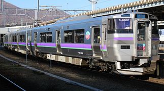
Hakodate Liner in Hakodate Station
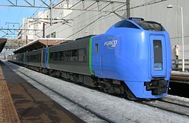
Great Hokuto at Shin-Sapporo

Great Kamui at Inō

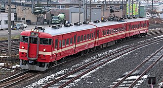
Freight train at Iwamizawa
Local train in Asahikawa


history
The state railway company Horonai Tetsudō opened on November 28, 1880 the section between Sapporo and Minami-Otaru , together with the subsequent Temiya line to the port of Otaru . It was the first railway line on Hokkaidō . A year and a half later, on June 25, 1882, it was extended from Sapporo to Ebetsu . Finally, on November 13, 1882, it reached the important coal field around Iwamizawa . The Japanese state sold the Horonai Tetsudō on December 11, 1889 to the mining and railway company Hokkaidō Tankō Tetsudō .
The new owner extended the route on July 5, 1891 from Iwamizawa to the Sorachi Bridge south of Takikawa . No private investors were found for further construction in the center of the island, which is why the Japanese Reichstag passed the "Hokkaidō Railway Construction Act" in May 1896. The then founded state company Hokkaidō Kansetsu Tetsudō built the section between the Sorachi Bridge and Asahikawa and put it into operation on July 16, 1898.
In May 1900, another private company, the Hokkaidō Tetsudō, was founded . It opened on December 10, 1902, two unconnected sections, on the one hand between Hakodate and Hongō (today Shin-Hakodate-Hokuto ), on the other hand between Shikaribetsu and Ranshima. The southern of the two sections was extended on June 28, 1903 from Hongō to Mori , the northern on the same day from Shikaribetsu to Yamanichi and from Ranshima to Otaru . Four months later, on November 3, 1903, the section from Mori via Oshamambe to Neppu was added. On July 18, 1904, the Yamanichi – Kozawa section was added, and the Kozawa – Neppu section on October 15. With the last gap closure on August 1, 1905 between Otaru and Minami-Otaru, the Hakodate main line was completed.
The Hokkaidō Kansetsu Tetsudō was placed on April 1, 1905 under the direct control of the Railway Office of the Cabinet (later the Ministry of Railways ). As a result of the nationalization law passed by the Reichstag, it took over the Hokkaidō Tankō Tetsudō on October 1, 1906 and the Hokkaidō Tetsudō on July 1, 1907, with the result that the entire route was now state-owned.
The Ministry of Railways built a 35.3 km alternative route between Mori and Ōnuma during the Pacific War . This so-called Sawara branch line went into operation on January 25, 1945. The stretch of the private railway Oshima Kaigan Tetsudō from Mori to Oshima-Sawara (length 9.4 km), which ran largely parallel to it and was built in 1927/28, was taken over by the state and closed on the same day. The Ministry of Railways built two-track sections of the Hakodate main line: Otaru – Sapporo – Iwamizawa (1909 to 1911), Iwamizawa – Sunagawa (1923 to 1926) and Hakodate – Kikyō (1941 to 1944).
The Japanese State Railways , responsible from 1949, opened the Asahikawa-Ōmachi freight yard in 1950, but it was only in operation until 1978. It also continued the double-track expansion, with the sections Sunagawa – Takikawa (1950 to 1956), Kikyō – Nanae (1962) and Takikawa – Osamunai (1964 to 1966). On October 1, 1966, she took the Fujishiro branch line between Nanae and Ōnuma into operation; it is used by trains traveling northwards, which can bypass a 2% steep incline. In several stages, from 1965 to 1979, most of the line between Mori and Oshamambe was double-tracked. On August 28, 1968 , the state railway electrified the Otaru – Sapporo – Takikawa section. The Takikawa – Asahikawa section, which was electrified on October 1, 1969, was given a more direct route east of Osamunai on the same day: instead of single-track through the narrow Ishikari Valley, the trains now ran double-track through two tunnels.
Almost a year after the privatization of the state railway, the section Hakodate - Goryōkaku was electrified on March 13, 1988 , in connection with the commissioning of the Seikan tunnel . In 2008, JR Hokkaido for the use of urban section Otaru Sapporo Iwamizawa contactless smart card Kitaca one. In preparation for the opening of the Hokkaidō-Shinkansen high-speed line , the section from Goryōkaku to the Shin-Hakodate-Hokuto transfer station was also electrified on March 21, 2013.
List of train stations
| Surname | km | Connecting lines | location | place | ||
|---|---|---|---|---|---|---|
| Main line | ||||||
| H75 | Hakodate ( 函館 ) | 0.0 | Hakodate tram | Coord. | Hakodate | |
| H74 | Goryōkaku ( 五 稜 郭 ) | 3.4 | Esashi line | Coord. | ||
| H73 | Kikyō ( 桔梗 ) | 8.3 | Coord. | |||
| H72 | Ōnakayama ( 大 中山 ) | 10.4 | Coord. | Nanae | ||
| H71 | Nanae ( 七 飯 ) | 13.8 | Coord. | |||
| H70 | Shin-Hakodate-Hokuto ( 新 函館 北斗 ) | 17.9 | Hokkaidō Shinkansen | Coord. | Hokuto | |
| H69 | Niyama ( 仁 山 ) | 21.2 | Coord. | Nanae | ||
| H68 | Ōnuma ( 大沼 ) | 27.0 | Sawara branch line | Coord. | ||
| H67 | Ōnumakōen ( 大沼 公園 ) | 28.0 | Coord. | |||
| H66 | Akaigawa ( 赤 井 川 ) | 31.7 | Coord. | Mori | ||
| H65 | Komagatake ( 駒 ヶ 岳 ) | 36.5 | Coord. | |||
| H62 | Mori ( 森 ) | 49.5 | Sawara branch line | Coord. | ||
| H61 | Katsuragawa ( 桂 川 ) | 52.2 | Coord. | |||
| H60 | Ishiya ( 石谷 ) | 56.1 | Coord. | |||
| H59 | Hon-Ishikura ( 本 石 倉 ) | 60.0 | Coord. | |||
| H58 | Ishikura ( 石 倉 ) | 62.1 | Coord. | |||
| H57 | Otoshibe ( 落 部 ) | 66.1 | Coord. | Yakumo | ||
| H56 | Nodaoi ( 野 田 生 ) | 71.4 | Coord. | |||
| H55 | Yamakoshi ( 山 越 ) | 76.6 | Coord. | |||
| H54 | Yakumo ( 八 雲 ) | 81.1 | Coord. | |||
| H53 | Washinosu ( 鷲 ノ 巣 ) | 84.2 | Coord. | |||
| H52 | Yamasaki ( 山崎 ) | 88.3 | Coord. | |||
| H51 | Kuroiwa ( 黒 岩 ) | 94.4 | Coord. | |||
| H50 | Kita-Toyotsu ( 北 豊 津 ) | 98.2 | Coord. | Oshamambe | ||
| H49 | Kunnui ( 国 縫 ) | 102.8 | Coord. | |||
| H48 | Nakanosawa ( 中 ノ 沢 ) | 107.7 | Coord. | |||
| H47 | Oshamambe ( 長 万 部 ) | 112.3 | Muroran main line | Coord. | ||
| S32 | Futamata ( 二 股 ) | 120.9 | Coord. | |||
| S31 | Warabitai ( 蕨 岱 ) | 126.9 | Coord. | |||
| S30 | Kuromatsunai ( 黒 松 内 ) | 132.3 | Coord. | Kuromatsunai | ||
| S29 | Neppu ( 熱 郛 ) | 140.4 | Coord. | |||
| S28 | Mena ( 目 名 ) | 155.8 | Coord. | Rankoshi | ||
| S27 | Rankoshi ( 蘭 越 ) | 163.4 | Coord. | |||
| S26 | Konbu ( 昆布 ) | 170.3 | Coord. | |||
| S25 | Niseko ( 蕨 岱 ) | 179.6 | Coord. | Niseko | ||
| S24 | Hirafu ( 蕨 岱 ) | 186.6 | Coord. | Kutchan | ||
| S23 | Kutchan ( 倶 知 安 ) | 193.3 | Coord. | |||
| S22 | Kozawa ( 小 沢 ) | 203.6 | Coord. | Kyōwa | ||
| S21 | Ginzan ( 銀山 ) | 213.4 | Coord. | Niki | ||
| S20 | Shikaribetsu ( 然 別 ) | 224.1 | Coord. | |||
| S19 | Niki ( 仁 木 ) | 228.2 | Coord. | |||
| S18 | Yoichi ( 余 市 ) | 232.6 | Coord. | Yoichi | ||
| S17 | Ranshima ( 蘭 島 ) | 237.9 | Coord. | Otaru | ||
| S16 | Shioya ( 塩 谷 ) | 244.8 | Coord. | |||
| S15 | Otaru ( 小樽 ) | 252.5 | Coord. | |||
| S14 | Minami-Otaru ( 南 小樽 ) | 254.1 | Coord. | |||
| S13 | Otaru-Chikkō ( 小樽 築 港 ) | 256.2 | Coord. | |||
| S12 | Asari ( 朝 里 ) | 259.3 | Coord. | |||
| S11 | Zenibako ( 銭 函 ) | 268.1 | Coord. | |||
| S10 | Hoshimi ( ほ し み ) | 271.0 | Coord. | Teine-ku , Sapporo | ||
| S09 | Hoshioki ( 星 置 ) | 272.6 | Coord. | |||
| S08 | Inaho ( 稲 穂 ) | 273.7 | Coord. | |||
| S07 | Teine ( 手 稲 ) | 275.7 | Coord. | |||
| S06 | Inazumikōen ( 稲 積 公園 ) | 277.0 | Coord. | |||
| S05 | Hassamu ( 発 寒 ) | 279.2 | Coord. | Nishi-ku , Sapporo | ||
| S04 | Hassamuchūō ( 発 寒 中央 ) | 281.0 | Coord. | |||
| S03 | Kotoni ( 琴 似 ) | 282.5 | Coord. | |||
| S02 | Sōen ( 桑園 ) | 284.7 | Sassho line | Coord. | Chūō-ku , Sapporo | |
| 01 | Sapporo ( 札幌 ) | 286.3 |
Sasshō Line Chitose Line Sapporo Subway |
Coord. | ||
| H02 | Naebo ( 苗 穂 ) | 288.5 | Coord. | |||
| H03 | Shiroishi ( 白石 ) | 292.1 | Chitose line | Coord. | Shiroishi-ku , Sapporo | |
| A04 | Atsubetsu ( 厚 別 ) | 296.5 | Coord. | Atsubetsu-ku , Sapporo | ||
| A05 | Shinrinkōen ( 森林 公園 ) | 298.5 | Coord. | |||
| A06 | Ōasa ( 大麻 ) | 300.8 | Coord. | Ebetsu | ||
| A07 | Nopporo ( 野 幌 ) | 304.2 | Coord. | |||
| A08 | Takasago ( 高 砂 ) | 305.5 | Coord. | |||
| A09 | Ebetsu ( 江 別 ) | 307.3 | Coord. | |||
| A10 | Toyohoro ( 豊 幌 ) | 313.5 | Coord. | |||
| A11 | Horomui ( 幌 向 ) | 316.7 | Coord. | Iwamizawa | ||
| A12 | Kami-Horomui ( 上 幌 向 ) | 322.6 | Coord. | |||
| A13 | Iwamizawa ( 岩 見 沢 ) | 326.9 | Muroran main line | Coord. | ||
| A14 | Minenobu ( 峰 延 ) | 335.3 | Coord. | Bibai | ||
| A15 | Kōshunai ( 光 珠 内 ) | 339.8 | Coord. | |||
| A16 | Bibai ( 美 唄 ) | 343.7 | Coord. | |||
| A17 | Chashinai ( 茶 志 内 ) | 348.1 | Coord. | |||
| A18 | Naie ( 奈 井 江 ) | 354.3 | Coord. | Naie | ||
| A19 | Toyonuma ( 豊 沼 ) | 359.0 | Coord. | Sunagawa | ||
| A20 | Sunagawa ( 砂 川 ) | 362.2 | Coord. | |||
| A21 | Takikawa ( 滝 川 ) | 369.8 | Nemuro main line | Coord. | Takikawa | |
| A22 | Ebeotsu ( 江 部 乙 ) | 378.2 | Coord. | |||
| A23 | Moseushi ( 妹 背 牛 ) | 385.7 | Coord. | Moseushi | ||
| A24 | Fukagawa ( 深 川 ) | 392.9 | Rumoi main line | Coord. | Fukagawa | |
| A25 | Osamunai ( 納 内 ) | 400.3 | Coord. | |||
| A26 | Inō ( 伊納 ) | 413.0 | Coord. | Asahikawa | ||
| A27 | Chikabumi ( 近 文 ) | 419.1 | Coord. | |||
| A28 | Asahikawa ( 旭川 ) | 423.1 |
Furano Line Sekihoku Main Line Sōya Main Line |
Coord. | ||
| Sawara branch line | ||||||
| H68 | Ōnuma ( 大沼 ) | 0.0 | Nanae | |||
| N71 | Ikedaen ( 池 田園 ) | 3.4 | Coord. | |||
| N70 | Nagareyama Onsen ( 流 山 温泉 ) | 5.6 | Coord. | |||
| N69 | Chōshiguchi ( 銚 子口 ) | 6.8 | Coord. | |||
| N68 | Shikabe ( 鹿 部 ) | 14.6 | Coord. | Shikabe | ||
| N67 | Oshima Numajiri ( 渡 島 沼 尻 ) | 20.0 | Coord. | Mori | ||
| N66 | Oshima-sawara ( 渡 島 砂 原 ) | 25.3 | Coord. | |||
| N65 | Kakarima ( 掛 澗 ) | 29.0 | Coord. | |||
| N64 | Oshironai ( 尾 白 内 ) | 31.9 | Coord. | |||
| N63 | Higashi-Mori ( 東 森 ) | 33.5 | Coord. | |||
| H62 | Mori ( 森 ) | 35.3 | ||||
Culture
A song of the same name by the Japanese enka singer Eiji Miyoshi is dedicated to the main Hakodate line .
Web links
Individual evidence
- ↑ a b c JR 時刻表 2016 年 3 月 号 (JR timetable March 2016). Kōtsū shinbunsha, Tokyo 2016.
- ↑ Naotaka Hirota: Steam Locomotives of Japan . (1972) Kodansha International Ltd., Tokyo 1972, ISBN 0-87011-185-X .
- ↑ SLNET Time Traveler (Japanese Steam Locomotives) The Niseko Express. (No longer available online.) Archived from the original on August 2, 2018 ; accessed on August 1, 2018 . Info: The archive link was inserted automatically and has not yet been checked. Please check the original and archive link according to the instructions and then remove this notice.
- ↑ a b c Kazuo Tanaka: 写真 で 見 る 北海道 の 鉄 道 (Hokkaidō's railroad in photos) . tape 1 . Hokkaidō Shinbunsha, Sapporo 2002, ISBN 978-4-89453-220-5 , pp. 36-37 .
- ↑ Tanaka: 写真 で 見 る 北海道 の 鉄 道, pp. 192–193.
- ↑ Tanaka: 写真 で 見 る 北海道 の 鉄 道, p. 311.
- ↑ a b Tanaka: 写真 で 見 る 北海道 の 鉄 道, pp. 38–39.
- ↑ a b c Tanaka: 写真 で 見 る 北海道 の 鉄 道, pp. 34–35.
- ↑ Kitaca サ ー ビ ス 開始 日 決定 に つ い て. (PDF, 108 kB) JR Hokkaido, September 10, 2008, archived from the original on September 13, 2008 ; accessed on June 26, 2016 (English).
Current lines: Hokkaidō-Shinkansen | Chitose line | Furano line | Hakodate main line | Hidaka main line | Kaikyō Line | Muroran main line | Nemuro main line | Rumoi main line | Sasshō Line | Sekihoku main line | Sekishō Line | Senmō main line | Sōya main line
Released Lines: Chihoku Line | Esashi line
Disused Lines: Horonai Line | Kamisunagawa branch line | Matsumae line | Nayoro main line | Shibetsu line | Shinmei line | Tenpoku Line | Utashinai line