
Teine-ku (Sapporo)
|
municipality of Sapporo |
|
|---|---|
 |
|
| Coordinates | 43 ° 7 '19 " N , 141 ° 14' 45" E |
| surface | 56.77 km² |
| Residents | 141,886 (Sep 30, 2019) |
| Population density | 2499 inhabitants / km² |
| Start-up | Nov 6, 1989 |
| Community key | 01109-6 |
| Website |
www.city.sapporo.jp/ teine / |
Teine-ku ( Japanese. 手 稲 区 ) is one of ten districts ( ku ) of Sapporo , the capital of the Japanese prefecture of Hokkaidō . It is 56.77 km² and is located on the northwestern outskirts. In the northwest it borders on the city of Otaru , in the northeast on the city of Ishikari , in the east on Kita-ku , in the south on Nishi-ku and in the southwest on Minami-ku .
geography
The district extends 10.9 km in an east-west direction and 9.4 km in a north-south direction. Its name is derived from the word teyne-i in the Ainu language , which can be translated as “moor” or “wet spot”. The southwest half of Teine-ku is mountainous. The highest point is the 1023 m high Teine-yama , its secondary peak Okuteine-yama reaches a height of 949 m. Several small rivers (Hoshioki, Kiraichi, Nigori, Santarubetsu, Tomioka) have their source on the Teine, the northern slope of which is used by the Sapporo Teine winter sports area . The Hoshioki waterfall and the Otome waterfall are worth seeing. The north-eastern half of the district, which lies on the edge of the extensive Ishikari plain , is largely flat. In the far north, the district extends almost to the coast of the Sea of Japan (the distance is around 400 meters). The rivers that spring from the Teine flow into the Shinkawa Canal, which flows to the sea.
history
Due to its convenient location, the area of today's district was one of the earliest to be settled by Japanese colonists in a coordinated manner. After the opening of a road from the coast towards Chitose in 1857, on the instructions of the Hakodate magistrate, farmers settled and began reclamation . Over time, several small villages emerged. In 1880 the state railway company Kan'ei Horonai Tetsudō opened the railway line between Sapporo and the port of Otaru , the following year the Teine station . In 1886/87 the Shinkawa Canal was built to drain the plain at the foot of the Teine-yama and make it more usable for agriculture. In 1902, Inamura, Teine and Yamaguchi merged to form the Teine community.
From 1922 to 1940 there was a 8.2 km long, horse-drawn small train with a gauge of 762 mm, which connected Teine with Ishikari . The Mitsubishi group mined gold , silver , copper and tin in the Teine mine from 1935 to 1971 . In 1951 the municipality of Teine received the status of a district town ( machi ). In 1966 it had a population of 30,000 and merged with Sapporo a year later. Various competitions from the 1972 Winter Olympics were held at Teine-yama. From April 1, 1972, the former city area belonged to the Nishi-ku district . Due to the strong population growth, the government created the new Teine-ku district on November 6, 1989 from its northern part.
traffic
Both National Road 5 and the Sasson Highway cross the district from southeast to northwest. Both connect Sapporo with the neighboring city of Otaru . In the north runs the national road 337 , which bypasses the urban area of Sapporo extensively.
Teine-ku is served by the Hakodate Main Line , Hokkaidō's most important railway line. The train stations Inazumikōen, Teine , Inaho, Hoshioki and Hoshimi are located on it. Teine train station is also an important hub for numerous bus routes operated by private companies.
Attractions
- Hoshioki waterfall
- Maeda forest park
- Otome waterfall
- Teinenadumi Park
- Sapporo Teine winter sports area

Teine-yama
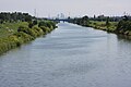
Shinkawa Canal

Otome waterfall
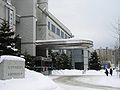
Town hall of Teine-ku
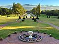
Maeda forest park


.jpg)
education
Web links
- Teine-ku website (Japanese)
Individual evidence
- ↑ 手 稲 区 の 概要 ・ 歴 史. Teine-ku, July 26, 2016, accessed April 17, 2018 (Japanese).
- ↑ a b 年表 で 見 る 手 稲 区. Teine-ku, March 1, 2013, accessed April 17, 2018 (Japanese).
- ↑ Keisuke Imao: 日本 鉄 道 旅行 地 図 帳 (Japan Rail Travel Atlas ) . tape 1 Hokkaidō. Shinchosha, Tokyo 2008, ISBN 978-4-10-790019-7 , pp. 34 .
Atsubetsu-ku | Chūō-ku | Higashi-ku | Kita-ku | Kiyota-ku | Minami-ku | Nishi-ku | Shiroishi-ku | Teine-ku | Toyohira-ku