
Minami-ku (Sapporo)
|
municipality of Sapporo |
|
|---|---|
 |
|
| Coordinates | 42 ° 59 '24 " N , 141 ° 21' 13" E |
| surface | 657.48 km² |
| Residents | 136,774 (Sep 30, 2019) |
| Population density | 208 inhabitants / km² |
| Start-up | Apr 1, 1972 |
| Community key | 01106-1 |
| Website |
www.city.sapporo.jp/ minami / |
Minami-ku ( Japanese 南 区 , dt. "Southern District") is one of ten boroughs ( ku ) of Sapporo , the capital of the Japanese prefecture of Hokkaidō . With 657.48 km² it takes up almost three fifths of the total area, due to its location in the mountains. Minami-ku borders in the north with Teine-ku , Nishi-ku and Chūō-ku , in the east with Toyohira-ku and Kiyota-ku , in the southeast with the city of Eniwa , in the south with the cities Chitose and Date , in the southwest with the City of Kimobetsu , in the west to the city of Kyōgoku and to the municipality of Akaigawa and in the northwest to the city of Otaru .
geography
The comparatively sparsely populated district extends over practically the entire south of the city; it also extends far to the northwest. Its area is 37.6 km long in north-south direction and 33.2 km in east-west direction. Essentially, Minami-ku comprises the valley along the Toyohira River and numerous side valleys. The most important tributaries of the Toyohira are Anano, Atsubetsu (including the Atsubetsu waterfall), Makomanai , Otarunai and Shiroi. There are several dams that are used to generate electrical energy: two of them, the Jōzankei Dam on Otarunai and the Hōheikyō Dam on Toyohira, dam large lakes, Sapporo Lake and Jōzan Lake.
Away from the valley plains of Toyohira and Makomanai, the terrain is very mountainous. No fewer than 17 mountains in the Minami-ku area are over 1,000 meters high. The highest is the Yoichi-dake (1488 m) on the western outskirts. Other prominent elevations are Muine-yama (1464 m), Izari-dake (1318 m), Shirai-dake (1301 m), Asari-dake (1287 m), Soranuma-dake (1251 m), Sapporo-dake (1293 m) ), Sausu-yama (1254 m), Tengu-dake (1145 m), Bibinai-yama (1028 m) and Teine-yama (1023 m). The upper Toyohira valley up to the confluence of the Shiroi is part of the Shikotsu-Tōya National Park . In the mouth area is the place Jōzankei with a widely known onsen .

Yoichi-dake

Atsubetsu waterfall
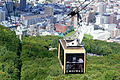
Cable car to Moiwa-yama

the Toyohira at the Jōzankei Onsen

Sapporo-dake

Toyama Dam


.JPG)


history
The first records go back to 1753 when a timber merchant cleared forest in the Toyohira Valley. The use of the Jōzankei Onsen began in 1866, and five years later a path was built along the Toyohira Valley. Tufa was first commercially mined in 1872, and various ore mines were added later. At the invitation of the government, the American rancher Edwin Dun began building a dairy farm on Makomanai in 1876. In the 1880s, settlers founded several villages. The villages ( mura ) Hiragishi, Toyohira and Tsukisamu merged on April 1, 1902 to form Toyohira municipality, which was part of ( gun ) Sapporo County . In 1908 the community received the status of a district city ( machi ).

In 1909 the Jōzankei power plant began producing electricity. In 1918 a private railway company took the 27.2 km long Jōzankei railway line between the Shiroishi station near Sapporo and the Jōzankei-Onsen into operation. From 1932 the Jōzankei-Onsen was also accessible via a road from Otaru . The US Army took possession of the Makomanai slaughterhouse in 1946, one year after the end of World War II , and expanded it into the Camp Crawford military base . In 1955 the Japanese Self-Defense Forces moved into the base. On May 1, 1961, the city of Toyohira merged with Sapporo. In 1969 the Jōzankei railway line was shut down; its route is partially used by the subway, which opened in 1971.
When the city of Sapporo hosted the 1972 Winter Olympics , numerous competitions were held in and around Makomanai Park , including biathlon , cross-country skiing , figure skating , ice hockey, and the Nordic combined cross-country race . On April 1 of the same year, the government divided the city of Sapporo into districts; In doing so, it struck the area of the former city of Toyohira largely to the district of Minami-ku, a small part in the far east formed the district of Toyohira-ku . After 15 years of construction, the 117 m high Jōzankei Dam was completed in 1989. In 2006, the Toyoha mine, the last lead and tin mine in Sapporo, ceased production. In the same year, the Sapporo Municipal University began teaching.
traffic

Minami-ku's main thoroughfare is National Road 230 , which runs through the Toyohira Valley and over the Nakayama Pass to the west. National Road 453 runs south towards Lake Shikotsu .
The northeastern part of Minami-ku is served by the Namboku Line of the Sapporo Subway , with Sumikawa, Jieitai-mae and Makomanai stations on the Namboku Line. There are also several bus routes operated by private companies. A cable car and a funicular lead up to the 531 m high Moiwa-yama mountain .
Attractions

- Makomanai Park with Makomanai Indoor Stadium , Makomanai Stadium and Salmon Museum
- Ainu cultural promotion center
- Edwin Dun Memorial Museum
- Jōzankei onsen
- Sapporo Art Park Center
- Sapporo Municipal Transport Museum
- Winter sports areas Moiwa-yama, Takino Snow World, Fu's Snow Area and Sapporo Kokusai Ski Resort
education
- Sapporo Municipal University
- Tōkai University (Sapporo Campus)
State institutions
The military base in the Makomanai district, which was originally built by the American occupation forces, is the headquarters of the 11th Infantry Brigade and also the Northern Army of the Self-Defense Forces (JSDF). Until 2005 it was one of the venues for the Sapporo Snow Festival . In Makomanai Also located Police Academy of the Prefecture of Police of Hokkaido.
Web links
- Minami-ku website (Japanese)
Individual evidence
- ↑ a b c 南 区 の 概要. Minami-ku, April 13, 2016, accessed April 17, 2018 (Japanese).
- ^ Map of the Shikotsu-Tōya National Park. (PDF, 2.4 MB) Japanese Ministry of the Environment, 2018, accessed April 17, 2018 .
- ↑ 歴 史 (1753 年 ~ 1899 年). Minami-ku, January 25, 2011, accessed April 17, 2018 (Japanese).
- ↑ 角 川 日本 地名 大 辞典 北海道 編, Volume 1, p. 1010. Kadokawa Shoten, Chiyoda 1987.
- ↑ 歴 史 (1900 年 ~ 1949 年). Minami-ku, January 25, 2011, accessed April 17, 2018 (Japanese).
- ↑ 歴 史 (1950 年 ~ 1979 年). Minami-ku, January 25, 2011, accessed April 17, 2018 (Japanese).
- ↑ 歴 史 (1980 年 ~ 1999 年). Minami-ku, January 25, 2011, accessed April 17, 2018 (Japanese).
- ↑ 歴 史 (2000 年 ~ 現在). Minami-ku, September 29, 2015, accessed April 17, 2018 (Japanese).
Atsubetsu-ku | Chūō-ku | Higashi-ku | Kita-ku | Kiyota-ku | Minami-ku | Nishi-ku | Shiroishi-ku | Teine-ku | Toyohira-ku