
Nishi-ku (Sapporo)
|
municipality of Sapporo |
|
|---|---|
 |
|
| Coordinates | 43 ° 4 ′ 28 " N , 141 ° 18 ′ 3" E |
| surface | 75.10 km² |
| Residents | 216,835 (Sep 30, 2019) |
| Population density | 2887 inhabitants / km² |
| Start-up | Apr 1, 1972 |
| Community key | 01107-0 |
| Website |
www.city.sapporo.jp/ nishi / |
Nishi-ku ( Japanese 西区 , German "western district") is one of ten districts ( ku ) of Sapporo , the capital of the Japanese prefecture of Hokkaidō . It is 75.10 km² and is located immediately west of the city center. In the north it borders on Teine-ku , in the northeast on Kita-ku , in the east and south on Chūō-ku and in the west on Minami-ku .
geography
The extension of Nishi-ku in east-west direction is 14.1 km, in north-south direction 11.3 km. The eastern third of the district lies in flat terrain on the edge of the Ishikari plain and is characterized by residential and commercial areas with an urban character. Soaring, wooded mountains and offshore hills dominate the landscape in the west. These include Teine-yama (1023 m), Hyakumatsuzawa-yama (1010 m), Mayoizawa-yama (986 m), Abe-yama (703 m), Sankaku-yama (311 m) and Goten-zan (304 m). The Sankaku-yama, in particular, with its triangular silhouette is very concise. The broad basin of the Kotonihassamu protrudes around two kilometers into the mountain range in the middle third of Nishi-ku. This river runs through the plain and finally flows into the Shinkawa Canal, which forms the northeastern border.
history
1857 sent Tokugawa - shogunate twenty Samurai along with companions to the area for colonization prepare; however, the establishment of a settlement did not succeed at that time. From 1871 the new imperial government settled numerous Tondenhei , military border colonists with their families, who cleared the land and founded small villages. From 1880 the Hakodate Main Line , Hokkaidō's first railway, ran through the area. In 1906 Hassamu, Kotoni and part of Shinoro merged to form Kotoni municipality. This received the status of a district city ( machi ) in 1942 .
Kotoni went up in 1955 in the city of Sapporo. From April 1, 1972, the area of the former town of Kotoni formed the new district of Nishi-ku. In 1974 an agricultural research institute started operations, and from 1976 the subway opened up the district. By government resolution, the northern half of Nishi-ku was split off on November 6, 1989 and has since formed the Teine-ku district .
traffic
The main traffic axes are the prefecture road 124 and the following national road , which lead north-west from the city center. The Sasson Autobahn crosses the district in the far north. Prefecture road 82 leads through the Talkassel and over the Kobayashi Pass to Minami-ku .
In the northeast runs the Hakodate Main Line , Hokkaidō's most important railway line. The railway stations Kotoni, Hassamuchūō and Hassamu are located on it. The Hachiken station is located on the branching Sasshō line in the far east. The district is also served by the Tōzai Line of the Sapporo Metro , with the stations Nijūyon-ken, Kotoni, Hassamu-minami and Miyanosawa. There are also various bus routes operated by private companies.
Attractions
- Gotenzan Park
- Heiwa waterfall
- Miyaoka Park

Nishi-ku City Hall
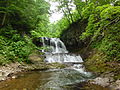
Heiwa waterfall at Kotonihassamu

Sankaku-yama
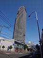
Sapporo Tower Kotoni


education
schools
Public
- Hokkaido Sapporo Seiryou High School
- Hokkaido Sapporo Kotoni Hokkaido Sapporo Kotoni
Private
- Sapporo Yamanote High School
Web links
- Nishi-ku website (Japanese)
Individual evidence
- ↑ a b プ ロ フ ィ ー ル. Nishi-ku, March 10, 2015, accessed April 17, 2018 (Japanese).
- ↑ a b 歴 史 年表. Nishi-ku, July 15, 2015, accessed April 17, 2018 (Japanese).
Atsubetsu-ku | Chūō-ku | Higashi-ku | Kita-ku | Kiyota-ku | Minami-ku | Nishi-ku | Shiroishi-ku | Teine-ku | Toyohira-ku